TopoQuest Logo
Do you find TopoQuest useful?
Help keep TopoQuest running and adding new maps/features by donating!
Bitcoin:  19c7KJd3qBynnjoSw5npx9KScwjBe4ifkT
Litecoin:  LXs6TkuXGGXo1vDsWCkWVdjQX94eUKd6ui
Home View Maps Find Maps Find Places Resources & Links


Silverdale, Kansas Topographic Map

USGS Map Title: Silverdale, KS
USGS Map MRC: 37096A8
DRG (GeoTIFF) Download: o37096a8.tif


Neighboring USGS Topographic Map Quads:


  Hackney, KS  
37097B1
 

  Winfield, KS  
37096B8
 

  Eaton, KS  
37096B7
 

  Arkansas City, KS  
37097A1
 

  Silverdale, KS  
37096A8
 

  Maple City, KS  
37096A7
 

  Newkirk, OK  
36097H1
 

  Kaw City NW, OK  
36096H8
 

  Hardy, OK  
36096H7


Map MRC Location:

N38°
W97°
N38°
W96°
H8 H7 H6 H5 H4 H3 H2 H1
G8 G7 G6 G5 G4 G3 G2 G1
F8 F7 F6 F5 F4 F3 F2 F1
E8 E7 E6 E5 E4 E3 E2 E1
D8 D7 D6 D5 D4 D3 D2 D1
C8 C7 C6 C5 C4 C3 C2 C1
B8 B7 B6 B5 B4 B3 B2 B1
A8 A7 A6 A5 A4 A3 A2 A1
N37°
W97°
N37°
W96°

Silverdale, KS USGS 1:24K Topographic Map Preview:
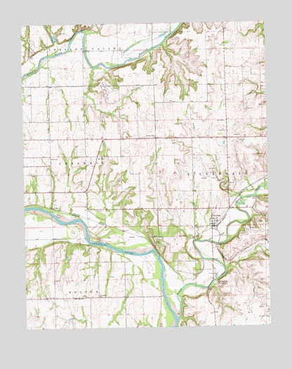
Silverdale, KS USGS Topographic Map
Click on map above to begin viewing in our Map Viewer.

This topographic map contains these locations and features:
Feature Name Type Latitude Longitude GNIS ID View Map
Baldwin School (historical)SchoolN37.0634°W96.9461°483400View Map
C - 4 Elementary SchoolSchoolN37.0697°W96.9615°469082View Map
Camp Ko-Ha-MeLocaleN37.0181°W96.9009°469031View Map
Charden Farms Airport (historical)AirportN37.0806°W96.9503°481454View Map
City of ParkerfieldCivilN37.0678°W96.9955°2396150View Map
Coburn School (historical)SchoolN37.0231°W96.9048°483409View Map
East Bolton SchoolSchoolN37.0123°W96.9756°469033View Map
Grandview ChurchChurchN37.0131°W96.9861°469034View Map
Grouse CreekStreamN37.0034°W96.9220°475047View Map
Grouse Creek ClubLocaleN37.0528°W96.8809°469083View Map
KACY - FM (Arkansas City)BuildingN37.0845°W96.9300°2625236View Map
KSOK - FM (Arkansas City)BuildingN37.0756°W96.9372°2625311View Map
Lake WyndsReservoirN37.0724°W96.9748°479867View Map
Lake Wynds DamDamN37.0717°W96.9753°479866View Map
Larcom Oil FieldOilfieldN37.1139°W96.9948°469085View Map
Louanns Mobile Home ParkPopulated PlaceN37.0537°W96.9965°2694117View Map
Marrs Field (historical)AirportN37.0750°W96.9689°481453View Map
Munson FieldAirportN37.0580°W96.9989°2770408View Map
Otter CreekStreamN37.0225°W96.8978°469035View Map
Parker CemeteryCemeteryN37.0696°W96.9875°469084View Map
ParkerfieldPopulated PlaceN37.0750°W96.9992°2061831View Map
Pleasant Valley (historical)Populated PlaceN37.1125°W96.9689°483456View Map
Pleasant Valley ChurchChurchN37.0778°W96.9323°469087View Map
Prairie View Christian CampLocaleN37.0322°W96.9640°2688751View Map
Shiloh School (historical)SchoolN37.0778°W96.9039°483474View Map
SilverdalePopulated PlaceN37.0420°W96.9034°469029View Map
Silverdale CemeteryCemeteryN37.0408°W96.9141°469030View Map
Springside CemeteryCemeteryN37.0132°W96.9635°469032View Map
Township of SilverdaleCivilN37.0635°W96.8770°469088View Map
Walnut Bend Oil and Gas FieldOilfieldN37.0973°W96.9586°469086View Map

Note: Coordinates in the location and feature list above are referenced to NAD83 datum.


Copyright (C) 2008-2024 Ryan Niemi / Sunset Dynamics ... All Rights Reserved