TopoQuest Logo
Do you find TopoQuest useful?
Help keep TopoQuest running and adding new maps/features by donating!
Bitcoin:  19c7KJd3qBynnjoSw5npx9KScwjBe4ifkT
Litecoin:  LXs6TkuXGGXo1vDsWCkWVdjQX94eUKd6ui
Home View Maps Find Maps Find Places Resources & Links


Sierra Fijardo, New Mexico Topographic Map

USGS Map Title: Sierra Fijardo, NM
USGS Map MRC: 33107D3
DRG (GeoTIFF) Download: o33107d3.tif


Neighboring USGS Topographic Map Quads:


  Vicks Peak, NM  
33107E4
 

  Steel Hill, NM  
33107E3
 

  Black Hill, NM  
33107E2
 

  Monticello, NM  
33107D4
 

  Sierra Fijardo, NM  
33107D3
 

  Romero Canyon, NM  
33107D2
 

  Priest Tank, NM  
33107C4
 

  Huerfano Hill, NM  
33107C3
 

  Black Bluffs, NM  
33107C2


Map MRC Location:

N34°
W108°
N34°
W107°
H8 H7 H6 H5 H4 H3 H2 H1
G8 G7 G6 G5 G4 G3 G2 G1
F8 F7 F6 F5 F4 F3 F2 F1
E8 E7 E6 E5 E4 E3 E2 E1
D8 D7 D6 D5 D4 D3 D2 D1
C8 C7 C6 C5 C4 C3 C2 C1
B8 B7 B6 B5 B4 B3 B2 B1
A8 A7 A6 A5 A4 A3 A2 A1
N33°
W108°
N33°
W107°

Sierra Fijardo, NM USGS 1:24K Topographic Map Preview:
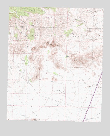
Sierra Fijardo, NM USGS Topographic Map
Click on map above to begin viewing in our Map Viewer.

This topographic map contains these locations and features:
Feature Name Type Latitude Longitude GNIS ID View Map
Aragon DrawValleyN33.4342°W107.3728°2025929View Map
Deer SpringsSpringN33.4963°W107.3445°905707View Map
Deer Springs CanyonValleyN33.4698°W107.3134°905708View Map
Ducknest TankReservoirN33.4585°W107.3395°937083View Map
Eagles RoostSummitN33.4609°W107.3242°905946View Map
Flying X 2 Water WellWellN33.4301°W107.3539°921995View Map
Flying X RanchLocaleN33.4301°W107.3542°906322View Map
Flying X Water WellWellN33.4315°W107.3536°921996View Map
H Bierner Number 2 ReservoirReservoirN33.3797°W107.3517°906799View Map
Lighting RidgeRidgeN33.4801°W107.3417°907952View Map
Los PillaresPillarN33.4915°W107.3639°1992149View Map
Los Pillares WellWellN33.4398°W107.3223°1992255View Map
Los TinajasValleyN33.4623°W107.3506°908231View Map
Marcus TankReservoirN33.4185°W107.3155°908412View Map
Peņasco CanyonValleyN33.4190°W107.2745°909547View Map
Peņasco PeakSummitN33.4590°W107.3173°909550View Map
Peņasco SpringSpringN33.4470°W107.2980°909551View Map
Rattlesnake HillSummitN33.4167°W107.3675°910023View Map
Sierra FijardoSummitN33.4140°W107.2686°911037View Map
Sierras MedianoSummitN33.3751°W107.3398°911044View Map
Street CanyonValleyN33.4673°W107.3503°911451View Map
Street WellWellN33.4673°W107.3509°937084View Map
Whiskey HillSummitN33.4403°W107.3528°912286View Map

Note: Coordinates in the location and feature list above are referenced to NAD83 datum.


Copyright (C) 2008-2024 Ryan Niemi / Sunset Dynamics ... All Rights Reserved