TopoQuest Logo
Do you find TopoQuest useful?
Help keep TopoQuest running and adding new maps/features by donating!
Bitcoin:  19c7KJd3qBynnjoSw5npx9KScwjBe4ifkT
Litecoin:  LXs6TkuXGGXo1vDsWCkWVdjQX94eUKd6ui
Home View Maps Find Maps Find Places Resources & Links


Saxeville, Wisconsin Topographic Map

USGS Map Title: Saxeville, WI
USGS Map MRC: 44089B1
DRG (GeoTIFF) Download: o44089b1.tif


Neighboring USGS Topographic Map Quads:


  King, WI  
44089C2
 

  Waupaca, WI  
44089C1
 

  Weyauwega, WI  
44088C8
 

  Wild Rose, WI  
44089B2
 

  Saxeville, WI  
44089B1
 

  Poy Sippi, WI  
44088B8
 

  Spring Lake, WI  
44089A2
 

  Redgranite, WI  
44089A1
 

  Auroraville, WI  
44088A8


Map MRC Location:

N45°
W90°
N45°
W89°
H8 H7 H6 H5 H4 H3 H2 H1
G8 G7 G6 G5 G4 G3 G2 G1
F8 F7 F6 F5 F4 F3 F2 F1
E8 E7 E6 E5 E4 E3 E2 E1
D8 D7 D6 D5 D4 D3 D2 D1
C8 C7 C6 C5 C4 C3 C2 C1
B8 B7 B6 B5 B4 B3 B2 B1
A8 A7 A6 A5 A4 A3 A2 A1
N44°
W90°
N44°
W89°

Saxeville, WI USGS 1:24K Topographic Map Preview:
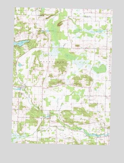
Saxeville, WI USGS Topographic Map
Click on map above to begin viewing in our Map Viewer.

This topographic map contains these locations and features:
Feature Name Type Latitude Longitude GNIS ID View Map
Austin CreekStreamN44.2289°W89.0315°1561027View Map
Baitenger LakeLakeN44.1968°W89.1168°1561099View Map
Big Cedar LakeLakeN44.2290°W89.0824°1561695View Map
Carpenter CreekStreamN44.1500°W89.0665°1562731View Map
Clarks Mill DamDamN44.2300°W89.0068°1792310View Map
Emaus ChurchChurchN44.2469°W89.0273°1564606View Map
Hilltop CemeteryCemeteryN44.1700°W89.1154°1566474View Map
Kristine Lake 2ReservoirN44.1839°W89.1154°1792676View Map
Little Cedar LakeLakeN44.2284°W89.0885°1568221View Map
Little Silver CreekStreamN44.1414°W89.0571°1568412View Map
Long LakeLakeN44.2163°W89.1249°1568581View Map
Magdanz CreekStreamN44.2289°W89.0412°1568892View Map
Mill PondReservoirN44.2295°W89.0178°1792311View Map
Mount Calvary CemeteryCemeteryN44.2136°W89.0346°1569803View Map
Peterson D5187 DamDamN44.1816°W89.1134°1792675View Map
Pine RiverPopulated PlaceN44.1522°W89.0771°1571516View Map
Pine River 3WR1564 DamDamN44.1516°W89.0751°1793253View Map
Pine River CemeteryCemeteryN44.1458°W89.0754°1571518View Map
Pine River Census Designated PlaceCensusN44.1483°W89.0757°2586543View Map
Pine River Millpond 100ReservoirN44.1516°W89.0751°1793254View Map
Pleasant View Elementary SchoolSchoolN44.1690°W89.0276°1576734View Map
SaxevillePopulated PlaceN44.1761°W89.1146°1573757View Map
Saxeville - Springwater Fire DepartmentBuildingN44.1763°W89.1153°2698046View Map
School PondLakeN44.2142°W89.0386°2784726View Map
Sorenson Hillview Jersey FarmLocaleN44.1469°W89.0822°2611849View Map
Town of SaxevilleCivilN44.1994°W89.0679°1584105View Map

Note: Coordinates in the location and feature list above are referenced to NAD83 datum.


Copyright (C) 2008-2024 Ryan Niemi / Sunset Dynamics ... All Rights Reserved