TopoQuest Logo
Do you find TopoQuest useful?
Help keep TopoQuest running and adding new maps/features by donating!
Bitcoin:  19c7KJd3qBynnjoSw5npx9KScwjBe4ifkT
Litecoin:  LXs6TkuXGGXo1vDsWCkWVdjQX94eUKd6ui
Home View Maps Find Maps Find Places Resources & Links


Sandymush, North Carolina Topographic Map

USGS Map Title: Sandymush, NC
USGS Map MRC: 35082F7
DRG (GeoTIFF) Download: o35082f7.tif


Neighboring USGS Topographic Map Quads:


  Lemon Gap, NC  
35082G8
 

  Spring Creek, NC  
35082G7
 

  Marshall, NC  
35082G6
 

  Fines Creek, NC  
35082F8
 

  Sandymush, NC  
35082F7
 

  Leicester, NC  
35082F6
 

  Clyde, NC  
35082E8
 

  Canton, NC  
35082E7
 

  Enka, NC  
35082E6


Map MRC Location:

N36°
W83°
N36°
W82°
H8 H7 H6 H5 H4 H3 H2 H1
G8 G7 G6 G5 G4 G3 G2 G1
F8 F7 F6 F5 F4 F3 F2 F1
E8 E7 E6 E5 E4 E3 E2 E1
D8 D7 D6 D5 D4 D3 D2 D1
C8 C7 C6 C5 C4 C3 C2 C1
B8 B7 B6 B5 B4 B3 B2 B1
A8 A7 A6 A5 A4 A3 A2 A1
N35°
W83°
N35°
W82°

Sandymush, NC USGS 1:24K Topographic Map Preview:
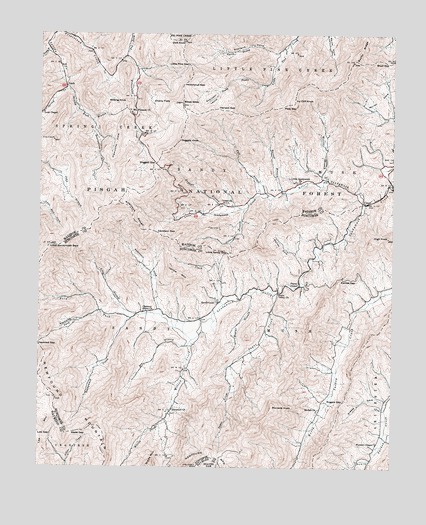
Sandymush, NC USGS Topographic Map
Click on map above to begin viewing in our Map Viewer.

This topographic map contains these locations and features:
Feature Name Type Latitude Longitude GNIS ID View Map
Bald ForkStreamN35.6676°W82.8424°1008870View Map
Barrett BranchStreamN35.7043°W82.7887°1008943View Map
Bearwallow BranchStreamN35.7248°W82.8574°1019020View Map
Bee BranchStreamN35.6598°W82.8221°1009098View Map
Bee BranchStreamN35.7490°W82.8640°1009105View Map
Beulah ChurchChurchN35.6421°W82.7760°1009244View Map
Boyd GapGapN35.7420°W82.7524°1009560View Map
CantoPopulated PlaceN35.7015°W82.7590°1010026View Map
Cherry FlatsFlatN35.7309°W82.8357°1010211View Map
Chestnut Grove ChurchChurchN35.6701°W82.8379°1010250View Map
Clark BranchStreamN35.6720°W82.8096°1010286View Map
Crossrock ChurchChurchN35.7009°W82.8071°1010595View Map
Davidson GapGapN35.6926°W82.8332°1010673View Map
Dick KnobSummitN35.7479°W82.8243°1019964View Map
Doggett BranchStreamN35.6995°W82.8035°1010861View Map
Doggett GapGapN35.7126°W82.8340°1010862View Map
Doggett KnobSummitN35.7193°W82.8257°1019998View Map
Earlies GapGapN35.6795°W82.7674°1010968View Map
Ebenezer ChurchChurchN35.6418°W82.8271°1011012View Map
Fall BranchStreamN35.7037°W82.7976°1020209View Map
Gilbert BranchStreamN35.6998°W82.8024°1020431View Map
Greasy BranchStreamN35.7457°W82.8718°1011677View Map
Greasy CoveValleyN35.6455°W82.7554°1011681View Map
Henson GapGapN35.7284°W82.8126°1011988View Map
Hickorynut GapGapN35.7359°W82.8243°1012021View Map
High KnobSummitN35.6915°W82.7515°1012039View Map
Hogeye BranchStreamN35.6757°W82.7999°1012104View Map
Icy Cliff KnobSummitN35.7312°W82.7851°1020877View Map
Jess CoveValleyN35.7449°W82.8724°1012469View Map
Jones Valley ChurchChurchN35.6757°W82.7907°1012563View Map
Leicester Volunteer Fire Department Station 2BuildingN35.6737°W82.8116°2638891View Map
Little Pine GapGapN35.7412°W82.8229°1013001View Map
Little Sandy GapGapN35.6868°W82.8082°1013025View Map
Little Sandymush BaldSummitN35.6890°W82.8707°1013026View Map
Little Sandymush ChurchChurchN35.7076°W82.7829°1013027View Map
Little Sandymush CreekStreamN35.7015°W82.7596°1013028View Map
Long BranchStreamN35.6687°W82.8404°1013120View Map
Low GapGapN35.6337°W82.8737°1013223View Map
LuckPopulated PlaceN35.7359°W82.8663°1021305View Map
Lusk ChapelChurchN35.7270°W82.8735°1013259View Map
Mikes KnobSummitN35.7298°W82.8251°1013528View Map
Morrow BranchStreamN35.7079°W82.7743°1013708View Map
Mount Pleasant ChurchChurchN35.7282°W82.8435°1021557View Map
Newfound MountainRidgeN35.6276°W82.8132°1023456View Map
North Prong Little Pine CreekStreamN35.7459°W82.7887°1014019View Map
Pady GapGapN35.7295°W82.7890°1014177View Map
Payne ChapelChurchN35.6776°W82.7829°1014277View Map
Pinnacle KnobSummitN35.6429°W82.7918°1021984View Map
Plemmons CoveValleyN35.7203°W82.8511°1014534View Map
Potato BranchStreamN35.6273°W82.7576°1014608View Map
Reynolds CoveValleyN35.6698°W82.8529°1014829View Map
Robinson CoveValleyN35.6704°W82.8322°1014977View Map
Robinson LaurelValleyN35.7327°W82.8120°1014980View Map
Robinson RoughRidgeN35.6984°W82.8424°1018169View Map
Rogers GapGapN35.6443°W82.7671°1015069View Map
SandymushPopulated PlaceN35.6726°W82.8112°1022495View Map
Sliding KnobSummitN35.7298°W82.8451°1022663View Map
Sliding Knob BranchStreamN35.7343°W82.8657°1022664View Map
South Prong Little Pine CreekStreamN35.7357°W82.7968°1015706View Map
Stevens CoveValleyN35.7447°W82.7918°1015822View Map
Sugar CreekStreamN35.6748°W82.7921°1015914View Map
Township 9, Sandy MushCivilN35.7189°W82.7734°2406936View Map
Township of Sandy MushCivilN35.6615°W82.8112°1026454View Map
Tug ForkStreamN35.7432°W82.8451°1016257View Map
Wade GapGapN35.6348°W82.8629°1016384View Map
Western ChapelChurchN35.6323°W82.7549°1016556View Map
Willow CreekStreamN35.6618°W82.8207°1016708View Map
Worley CoveValleyN35.6874°W82.7863°1016838View Map
Yellow MountainSummitN35.6807°W82.8262°1023344View Map

Note: Coordinates in the location and feature list above are referenced to NAD83 datum.


Copyright (C) 2008-2024 Ryan Niemi / Sunset Dynamics ... All Rights Reserved