TopoQuest Logo
Do you find TopoQuest useful?
Help keep TopoQuest running and adding new maps/features by donating!
Bitcoin:  19c7KJd3qBynnjoSw5npx9KScwjBe4ifkT
Litecoin:  LXs6TkuXGGXo1vDsWCkWVdjQX94eUKd6ui
Home View Maps Find Maps Find Places Resources & Links


Salyer, California Topographic Map

USGS Map Title: Salyer, CA
USGS Map MRC: 40123H5
DRG (GeoTIFF) Download: o40123h5.tif


Neighboring USGS Topographic Map Quads:


  Hoopa, CA  
41123A6
 

  Tish Tang Point, CA  
41123A5
 

  Trinity Mountain, CA  
41123A4
 

  Willow Creek, CA  
40123H6
 

  Salyer, CA  
40123H5
 

  Denny, CA  
40123H4
 

  Grouse Mountain, CA  
40123G6
 

  Hennessy Peak, CA  
40123G5
 

  Ironside Mountain, CA  
40123G4


Map MRC Location:

N41°
W124°
N41°
W123°
H8 H7 H6 H5 H4 H3 H2 H1
G8 G7 G6 G5 G4 G3 G2 G1
F8 F7 F6 F5 F4 F3 F2 F1
E8 E7 E6 E5 E4 E3 E2 E1
D8 D7 D6 D5 D4 D3 D2 D1
C8 C7 C6 C5 C4 C3 C2 C1
B8 B7 B6 B5 B4 B3 B2 B1
A8 A7 A6 A5 A4 A3 A2 A1
N40°
W124°
N40°
W123°

Salyer, CA USGS 1:24K Topographic Map Preview:
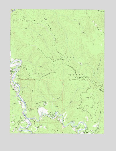
Salyer, CA USGS Topographic Map
Click on map above to begin viewing in our Map Viewer.

This topographic map contains these locations and features:
Feature Name Type Latitude Longitude GNIS ID View Map
Baldwin RidgeRidgeN40.9362°W123.6028°218617View Map
Bloody Nose CreekStreamN40.9382°W123.6187°219464View Map
Bremer CreekStreamN40.9474°W123.6112°219794View Map
Butterfly CreekStreamN40.9299°W123.6237°220302View Map
Camp Kimtu Recreation SiteLocaleN40.9507°W123.6178°276368View Map
Campbell RidgeRidgeN40.9151°W123.5962°220514View Map
China CreekStreamN40.9249°W123.6192°221023View Map
China FlatFlatN40.9218°W123.6173°221031View Map
Groves Prairie CreekStreamN40.9335°W123.5148°224681View Map
Hawkins Bar Fire DepartmentBuildingN40.8768°W123.5330°2622216View Map
Hawkins CreekStreamN40.8812°W123.5248°225034View Map
Horse Range CreekStreamN40.9937°W123.5617°225625View Map
Hudson CreekStreamN40.9182°W123.6128°225729View Map
Lone Pine RidgeRidgeN40.9899°W123.5173°234187View Map
Maple SpringSpringN40.9899°W123.5801°228062View Map
Old Campbell CreekStreamN40.8810°W123.6120°227902View Map
Quinby CreekStreamN40.8940°W123.5575°231144View Map
Russell Cabin (historical)BuildingN40.9007°W123.5645°1665277View Map
SalyerPopulated PlaceN40.8901°W123.5845°232346View Map
Salyer Forest Service FacilityLocaleN40.8887°W123.5845°276369View Map
Salyer Post OfficePost OfficeN40.8906°W123.5843°1683055View Map
Salyer Volunteer Fire DepartmentBuildingN40.8924°W123.5868°2621906View Map
Salyer Work CenterLocaleN40.8885°W123.5848°232347View Map
Schoolhouse CreekStreamN40.9104°W123.6134°232677View Map
Sharber CreekStreamN40.8960°W123.5650°232864View Map
South Fork Trinity RiverStreamN40.8899°W123.6023°249724View Map
Trinity VillagePopulated PlaceN40.8754°W123.5284°1660033View Map
Trinity Village Census Designated PlaceCensusN40.8789°W123.5132°2611452View Map
Victor CreekStreamN40.9379°W123.6226°237067View Map
Waterman RidgeRidgeN40.9751°W123.5695°237339View Map
Zeigler PointCapeN40.9112°W123.5200°238311View Map

Note: Coordinates in the location and feature list above are referenced to NAD83 datum.


Copyright (C) 2008-2024 Ryan Niemi / Sunset Dynamics ... All Rights Reserved