TopoQuest Logo
Do you find TopoQuest useful?
Help keep TopoQuest running and adding new maps/features by donating!
Bitcoin:  19c7KJd3qBynnjoSw5npx9KScwjBe4ifkT
Litecoin:  LXs6TkuXGGXo1vDsWCkWVdjQX94eUKd6ui
Home View Maps Find Maps Find Places Resources & Links


Saint Regis Falls, New York Topographic Map

USGS Map Title: Saint Regis Falls, NY
USGS Map MRC: 44074F5
DRG (GeoTIFF) Download: o44074f5.tif


Neighboring USGS Topographic Map Quads:


  North Lawrence, NY  
44074G6
 

  Brushton, NY  
44074G5
 

  Bangor, NY  
44074G4
 

  Nicholville, NY  
44074F6
 

  Saint Regis Falls, NY  
44074F5
 

  Santa Clara, NY  
44074F4
 

  Sylvan Falls, NY  
44074E6
 

  Lake Ozonia, NY  
44074E5
 

  Meno, NY  
44074E4


Map MRC Location:

N45°
W75°
N45°
W74°
H8 H7 H6 H5 H4 H3 H2 H1
G8 G7 G6 G5 G4 G3 G2 G1
F8 F7 F6 F5 F4 F3 F2 F1
E8 E7 E6 E5 E4 E3 E2 E1
D8 D7 D6 D5 D4 D3 D2 D1
C8 C7 C6 C5 C4 C3 C2 C1
B8 B7 B6 B5 B4 B3 B2 B1
A8 A7 A6 A5 A4 A3 A2 A1
N44°
W75°
N44°
W74°

Saint Regis Falls, NY USGS 1:24K Topographic Map Preview:
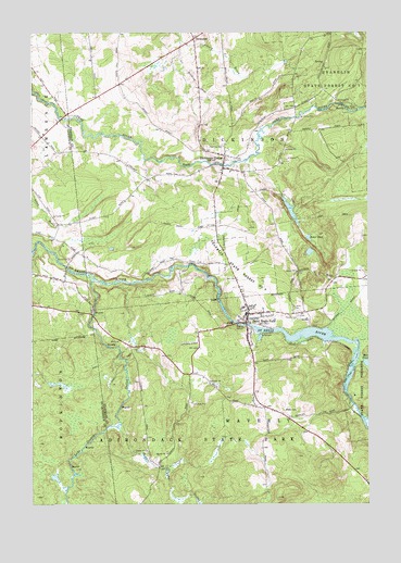
Saint Regis Falls, NY USGS Topographic Map
Click on map above to begin viewing in our Map Viewer.

This topographic map contains these locations and features:
Feature Name Type Latitude Longitude GNIS ID View Map
Baker PondLakeN44.6919°W74.5214°942841View Map
Deer River Picnic AreaLocaleN44.7306°W74.5052°948234View Map
Dexter Lake OutletStreamN44.6453°W74.5930°948397View Map
DickinsonPopulated PlaceN44.7484°W74.5646°972383View Map
Dickinson CenterPopulated PlaceN44.7176°W74.5527°948441View Map
Dickinson Center Post OfficePost OfficeN44.7143°W74.5527°2617890View Map
Dickinson Volunteer Fire DepartmentBuildingN44.7143°W74.5526°2718400View Map
Fairview CemeteryCemeteryN44.7198°W74.5596°949848View Map
Forest CemeteryCemeteryN44.6749°W74.5260°950390View Map
Franklin State Forest Number NineForestN44.6862°W74.5482°950634View Map
Guide Board School (historical)SchoolN44.6269°W74.5003°2493693View Map
Ives CemeteryCemeteryN44.7165°W74.5493°953861View Map
Lake Ozonia OutletStreamN44.6842°W74.6024°976530View Map
Lake Ozonia School (historical)SchoolN44.6328°W74.5794°2493694View Map
Mud PondLakeN44.6623°W74.5004°970389View Map
Palmer School (historical)SchoolN44.6506°W74.5378°2493695View Map
Saint Anns CemeteryCemeteryN44.6760°W74.5260°963304View Map
Saint Regis FallsPopulated PlaceN44.6739°W74.5449°964190View Map
Saint Regis Falls Census Designated PlaceCensusN44.6764°W74.5310°2628185View Map
Saint Regis Falls Central SchoolSchoolN44.6795°W74.5445°2669098View Map
Saint Regis Falls Post OfficePost OfficeN44.6747°W74.5449°2618103View Map
Saint Regis Falls Volunteer Fire DepartmentBuildingN44.6733°W74.5438°2735009View Map
Saint Regis River BridgeBridgeN44.6729°W74.5486°2614979View Map
School Number 2 (historical)SchoolN44.6669°W74.5853°2493696View Map
School Number 3 (historical)SchoolN44.6906°W74.5289°2493697View Map
School Number 5 (historical)SchoolN44.6886°W74.5672°2493698View Map
School Number 6 (historical)SchoolN44.7114°W74.5822°2493699View Map
Town of DickinsonCivilN44.7299°W74.5448°978904View Map

Note: Coordinates in the location and feature list above are referenced to NAD83 datum.


Copyright (C) 2008-2024 Ryan Niemi / Sunset Dynamics ... All Rights Reserved