TopoQuest Logo
Do you find TopoQuest useful?
Help keep TopoQuest running and adding new maps/features by donating!
Bitcoin:  19c7KJd3qBynnjoSw5npx9KScwjBe4ifkT
Litecoin:  LXs6TkuXGGXo1vDsWCkWVdjQX94eUKd6ui
Home View Maps Find Maps Find Places Resources & Links


Saddleback Mountain, Maine Topographic Map

USGS Map Title: Saddleback Mountain, ME
USGS Map MRC: 44070H5
DRG (GeoTIFF) Download: o44070h5.tif


Neighboring USGS Topographic Map Quads:


  Kennebago Lake, ME  
45070A6
 

  Quill Hill, ME  
45070A5
 

  Black Nubble, ME  
45070A4
 

  Rangeley, ME  
44070H6
 

  Saddleback Mountain, ME  
44070H5
 

  Redington, ME  
44070H4
 

  Houghton, ME  
44070G6
 

  Jackson Mountain, ME  
44070G5
 

  Madrid, ME  
44070G4


Map MRC Location:

N45°
W71°
N45°
W70°
H8 H7 H6 H5 H4 H3 H2 H1
G8 G7 G6 G5 G4 G3 G2 G1
F8 F7 F6 F5 F4 F3 F2 F1
E8 E7 E6 E5 E4 E3 E2 E1
D8 D7 D6 D5 D4 D3 D2 D1
C8 C7 C6 C5 C4 C3 C2 C1
B8 B7 B6 B5 B4 B3 B2 B1
A8 A7 A6 A5 A4 A3 A2 A1
N44°
W71°
N44°
W70°

Saddleback Mountain, ME USGS 1:24K Topographic Map Preview:
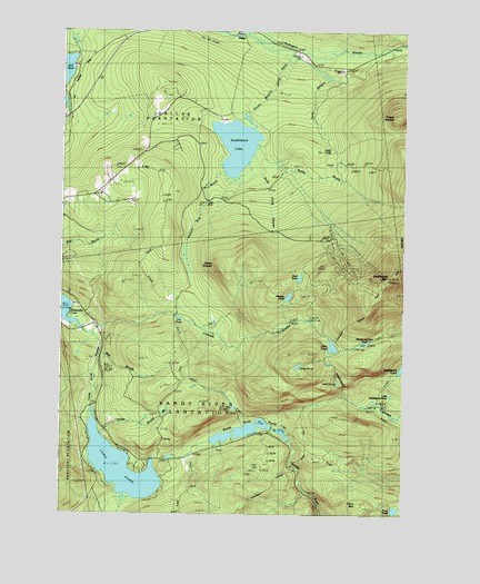
Saddleback Mountain, ME USGS Topographic Map
Click on map above to begin viewing in our Map Viewer.

This topographic map contains these locations and features:
Feature Name Type Latitude Longitude GNIS ID View Map
Brooks CemeteryCemeteryN44.8920°W70.5672°2736274View Map
Cascade StreamStreamN44.9214°W70.6123°563658View Map
City PondReservoirN44.9258°W70.5816°564007View Map
City Pond DamDamN44.9261°W70.5832°1774539View Map
Cold StreamStreamN44.9942°W70.5387°564194View Map
DallasPopulated PlaceN44.9970°W70.5559°579228View Map
Dead River DamDamN44.9786°W70.5584°1774203View Map
Eddy PondLakeN44.9185°W70.5256°565780View Map
Ethel PondLakeN44.9087°W70.5220°565945View Map
Flagg DamDamN44.9987°W70.5581°566269View Map
Geneva Bog BrookStreamN44.9645°W70.5645°566734View Map
Greenvale SchoolSchoolN44.9234°W70.6087°567302View Map
Haley BrookStreamN44.8956°W70.6084°567443View Map
Haley BrookStreamN44.9689°W70.5526°567444View Map
Ledge PondLakeN44.9135°W70.5380°569449View Map
Little Saddleback PondLakeN44.9059°W70.5026°570039View Map
Long PondLakeN44.8868°W70.6023°570283View Map
Long Pond StreamStreamN44.9251°W70.6209°570311View Map
Midway PondLakeN44.9313°W70.5420°571275View Map
Mill BrookStreamN44.9164°W70.6076°571301View Map
Moose and Deer PondLakeN44.9195°W70.5138°571573View Map
Oakes NubbleSummitN44.9390°W70.5674°572644View Map
Oakes Peary CemeteryCemeteryN44.9645°W70.6025°2736301View Map
Perry MountainSummitN44.8780°W70.5141°573219View Map
Perry PondLakeN44.8764°W70.5024°573221View Map
Piazza RockPillarN44.9167°W70.5248°1908398View Map
Piazza Rock TrailTrailN44.9112°W70.5245°1908399View Map
Plantation of DallasCivilN44.9928°W70.5756°582431View Map
Plantation of Sandy RiverCivilN44.9052°W70.5570°582711View Map
Potato NubbleSummitN44.9782°W70.5019°573716View Map
Redington StreamStreamN44.9995°W70.5503°574109View Map
Rock PondLakeN44.9363°W70.5379°574348View Map
Rock Pond StreamStreamN44.9651°W70.5565°574352View Map
Saddleback LakeReservoirN44.9705°W70.5613°574663View Map
Saddleback MountainSummitN44.9364°W70.5046°574668View Map
Saddleback Ski AreaLocaleN44.9473°W70.5273°1908420View Map
Sandy River PondsLakeN44.8965°W70.5587°574893View Map

Note: Coordinates in the location and feature list above are referenced to NAD83 datum.


Copyright (C) 2008-2024 Ryan Niemi / Sunset Dynamics ... All Rights Reserved