TopoQuest Logo
Do you find TopoQuest useful?
Help keep TopoQuest running and adding new maps/features by donating!
Bitcoin:  19c7KJd3qBynnjoSw5npx9KScwjBe4ifkT
Litecoin:  LXs6TkuXGGXo1vDsWCkWVdjQX94eUKd6ui
Home View Maps Find Maps Find Places Resources & Links


Ruth, Nevada Topographic Map

USGS Map Title: Ruth, NV
USGS Map MRC: 39114C8
DRG (GeoTIFF) Download: o39114c8.tif


Neighboring USGS Topographic Map Quads:


  Robinson Summit, NV  
39115D1
 

  Lusetti Canyon, NV  
39114D8
 

  McGill, NV  
39114D7
 

  Riepetown, NV  
39115C1
 

  Ruth, NV  
39114C8
 

  East Ely, NV  
39114C7
 

  Giroux Wash, NV  
39115B1
 

  Ely, NV  
39114B8
 

  Comins Lake, NV  
39114B7


Map MRC Location:

N40°
W115°
N40°
W114°
H8 H7 H6 H5 H4 H3 H2 H1
G8 G7 G6 G5 G4 G3 G2 G1
F8 F7 F6 F5 F4 F3 F2 F1
E8 E7 E6 E5 E4 E3 E2 E1
D8 D7 D6 D5 D4 D3 D2 D1
C8 C7 C6 C5 C4 C3 C2 C1
B8 B7 B6 B5 B4 B3 B2 B1
A8 A7 A6 A5 A4 A3 A2 A1
N39°
W115°
N39°
W114°

Ruth, NV USGS 1:24K Topographic Map Preview:
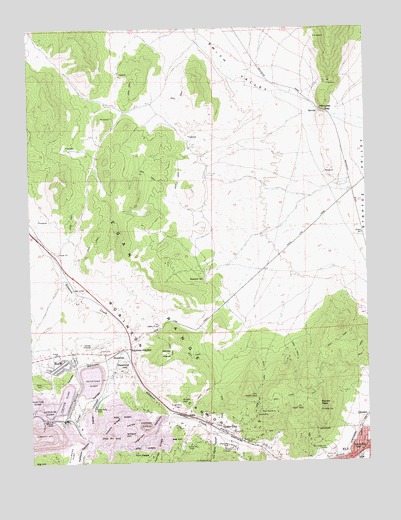
Ruth, NV USGS Topographic Map
Click on map above to begin viewing in our Map Viewer.

This topographic map contains these locations and features:
Feature Name Type Latitude Longitude GNIS ID View Map
Ada HillSummitN39.2561°W114.9475°845338View Map
Ada ShaftMineN39.2599°W114.9472°838379View Map
Aultman MineMineN39.2561°W114.9275°853524View Map
Bolo SpringSpringN39.3326°W114.9350°850966View Map
Boston Mine ShaftMineN39.2566°W114.9231°838986View Map
Brilliant ShaftMineN39.2538°W114.9650°850958View Map
CalumetPopulated PlaceN39.2630°W114.8767°855983View Map
Central Ely School (historical)SchoolN39.2536°W114.8814°857938View Map
Chainman ShaftMineN39.2549°W114.9281°854395View Map
Clipper ShaftMineN39.2666°W114.9975°850964View Map
Columbia ShaftMineN39.2597°W114.9611°854771View Map
Copper FlatPopulated PlaceN39.2610°W114.9881°850961View Map
Deep Ruth ShaftMineN39.2658°W114.9772°839967View Map
Deuce MineMineN39.2636°W114.9175°840018View Map
Elijah HillSummitN39.2677°W114.9453°845451View Map
Elijah MineMineN39.2660°W114.9478°840329View Map
Ely-Centennial TunnelMineN39.2536°W114.8945°840343View Map
Eureka ShaftMineN39.2594°W114.9870°850962View Map
Fisher CanyonValleyN39.2694°W114.9750°840484View Map
Four Ace MineMineN39.2649°W114.9142°863917View Map
Garnet FieldsFlatN39.2813°W114.9506°840617View Map
Garnet Fields Rockhound AreaAreaN39.2810°W114.9467°856845View Map
Garnet HillSummitN39.2699°W114.9197°850952View Map
Garnet Hill MineMineN39.2799°W114.9489°853521View Map
Hayes RidgeRidgeN39.2610°W114.9709°840924View Map
Hayes ShaftMineN39.2652°W114.9681°854769View Map
Hercules GapGapN39.3508°W114.8914°847357View Map
Hercules Mining DistrictCivilN39.3499°W114.9342°850950View Map
Ingersol CanyonValleyN39.2638°W114.9495°860133View Map
Isaacs MineMineN39.2869°W114.9628°853520View Map
Juniper DumpLocaleN39.2685°W114.9884°841444View Map
Juniper ShaftMineN39.2555°W114.9570°850959View Map
Jupiter RidgeRidgeN39.2538°W114.9542°860238View Map
KELY-FM (Ely)TowerN39.2644°W114.8939°865082View Map
KeystonePopulated PlaceN39.2819°W114.9684°856058View Map
Keystone DumpLocaleN39.2735°W114.9781°841482View Map
Keystone HillSummitN39.2774°W114.9672°841483View Map
Keystone JunctionPopulated PlaceN39.2830°W114.9639°856059View Map
Keystone MineMineN39.2763°W114.9656°853522View Map
Kimbley PitMineN39.2602°W114.9584°854504View Map
LaneLocaleN39.2630°W114.9414°848570View Map
Lane CityPopulated PlaceN39.2605°W114.9314°845529View Map
Lane Post OfficePost OfficeN39.2605°W114.9314°864280View Map
Lane ValleyValleyN39.2544°W114.9195°841568View Map
Liberty PitMineN39.2574°W114.9981°863921View Map
Mineral CityPopulated PlaceN39.2644°W114.9478°850951View Map
Monitor ShaftMineN39.2624°W114.9934°842189View Map
Monroe MineMineN39.2652°W114.9581°853526View Map
New Ruth Elementary SchoolSchoolN39.2794°W114.9900°855086View Map
Ocher ValleyValleyN39.2744°W114.9717°842596View Map
Puritan DumpFlatN39.2669°W114.9992°843005View Map
Ragsdale SpringSpringN39.3027°W114.9365°843055View Map
Revenue ShaftMineN39.2530°W114.9303°854592View Map
Robinson Mining DistrictCivilN39.2869°W114.9628°853523View Map
Robust MillLocaleN39.2552°W114.9170°850956View Map
RuthPopulated PlaceN39.2783°W114.9892°845643View Map
Ruth (historical)Populated PlaceN39.2572°W114.9803°863120View Map
Ruth Census Designated PlaceCensusN39.2793°W114.9900°2629979View Map
Ruth Post OfficePost OfficeN39.2801°W114.9848°864338View Map
Ruth School (historical)SchoolN39.2588°W114.9806°858308View Map
Ruth ShaftMineN39.2555°W114.9678°850957View Map
Ruth Volunteer Fire DepartmentBuildingN39.2789°W114.9850°2581321View Map
Saxton ShaftMineN39.2547°W114.9406°845653View Map
Smith ValleyValleyN39.3513°W114.8934°843782View Map
Squaw PeakSummitN39.2661°W114.8936°845681View Map
Star Pointer ShaftMineN39.2563°W114.9775°850963View Map
Stillwater DumpFlatN39.2510°W114.9864°861594View Map
Sunshine Camp (historical)Populated PlaceN39.2719°W114.9878°851927View Map
Sunshine DumpFlatN39.2647°W114.9978°844109View Map
The CliffsSlopeN39.2749°W114.9875°845700View Map
The Rabbit CanyonValleyN39.2577°W114.9331°861708View Map
The Rabbit MineMineN39.2513°W114.9367°844275View Map
Tonopah CanyonValleyN39.2560°W114.9789°861753View Map
Twin PeaksSummitN39.2530°W114.9597°845720View Map
Verza CanyonValleyN39.2619°W114.9564°856417View Map
Watson SpringSpringN39.2624°W114.9403°850960View Map
Wedge PitMineN39.2869°W114.9628°853527View Map
Willard HillSummitN39.2572°W114.9661°845745View Map
Willard MineMineN39.2649°W114.9578°853525View Map
Witch ShaftMineN39.2588°W114.9539°854770View Map

Note: Coordinates in the location and feature list above are referenced to NAD83 datum.


Copyright (C) 2008-2024 Ryan Niemi / Sunset Dynamics ... All Rights Reserved