TopoQuest Logo
Do you find TopoQuest useful?
Help keep TopoQuest running and adding new maps/features by donating!
Bitcoin:  19c7KJd3qBynnjoSw5npx9KScwjBe4ifkT
Litecoin:  LXs6TkuXGGXo1vDsWCkWVdjQX94eUKd6ui
Home View Maps Find Maps Find Places Resources & Links


Roubidoux, Missouri Topographic Map

USGS Map Title: Roubidoux, MO
USGS Map MRC: 37092D2
DRG (GeoTIFF) Download: o37092d2.tif


Neighboring USGS Topographic Map Quads:


  Winnipeg, MO  
37092E3
 

  Roby, MO  
37092E2
 

  Slabtown Spring, MO  
37092E1
 

  Manes, MO  
37092D3
 

  Roubidoux, MO  
37092D2
 

  Success, MO  
37092D1
 

  Dawson, MO  
37092C3
 

  Huggins, MO  
37092C2
 

  Bucyrus, MO  
37092C1


Map MRC Location:

N38°
W93°
N38°
W92°
H8 H7 H6 H5 H4 H3 H2 H1
G8 G7 G6 G5 G4 G3 G2 G1
F8 F7 F6 F5 F4 F3 F2 F1
E8 E7 E6 E5 E4 E3 E2 E1
D8 D7 D6 D5 D4 D3 D2 D1
C8 C7 C6 C5 C4 C3 C2 C1
B8 B7 B6 B5 B4 B3 B2 B1
A8 A7 A6 A5 A4 A3 A2 A1
N37°
W93°
N37°
W92°

Roubidoux, MO USGS 1:24K Topographic Map Preview:
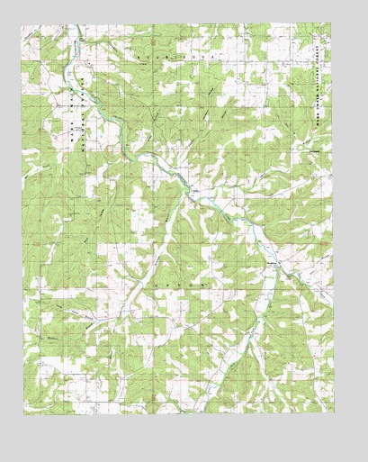
Roubidoux, MO USGS Topographic Map
Click on map above to begin viewing in our Map Viewer.

This topographic map contains these locations and features:
Feature Name Type Latitude Longitude GNIS ID View Map
Burkhart BranchStreamN37.4478°W92.1835°749118View Map
Carr BranchStreamN37.4178°W92.1377°749220View Map
Coghill HollowValleyN37.4534°W92.1893°749403View Map
Cote SandyBendN37.4581°W92.1327°749486View Map
Cov BranchStreamN37.4612°W92.1393°749500View Map
Dearborn CreekStreamN37.4948°W92.2268°749599View Map
East Fork Roubidoux CreekStreamN37.4225°W92.1477°749779View Map
EmbreeLocaleN37.3909°W92.2424°740548View Map
Embree Post OfficePost OfficeN37.3909°W92.2424°760100View Map
Huggins Volunteer Fire Department Station 2BuildingN37.4064°W92.2434°2620711View Map
Jackson CemeteryCemeteryN37.4075°W92.1565°750480View Map
Jackson HollowValleyN37.4634°W92.1785°750486View Map
Liberty SchoolSchoolN37.4484°W92.1668°750701View Map
Long Valley BranchStreamN37.4045°W92.2188°750856View Map
Long Valley School (historical)SchoolN37.4050°W92.2202°750857View Map
Lynch CemeteryCemeteryN37.4903°W92.2238°750894View Map
Mill CreekStreamN37.4756°W92.2202°751070View Map
Mill Creek School (historical)SchoolN37.4628°W92.2249°751079View Map
Mount Pisgah Church (historical)ChurchN37.4939°W92.1593°751189View Map
Mount Pisgah SchoolSchoolN37.4887°W92.1685°751192View Map
Old Concord CemeteryCemeteryN37.3789°W92.1790°751413View Map
Old Union CemeteryCemeteryN37.3865°W92.2241°751429View Map
Pegasus Ranch AerodromeAirportN37.3794°W92.2126°758727View Map
Price HollowValleyN37.4578°W92.2046°751758View Map
RoubidouxPopulated PlaceN37.4225°W92.1479°751968View Map
Timber Ridge SchoolSchoolN37.4098°W92.1696°752545View Map
Township of UptonCivilN37.4078°W92.1699°767477View Map
TurleyPopulated PlaceN37.4467°W92.1821°752614View Map
West Fork Roubidoux CreekStreamN37.4225°W92.1477°752823View Map
Wilson HollowValleyN37.4045°W92.2127°752927View Map
Windy CurvePopulated PlaceN37.4862°W92.1285°735319View Map
Wolf BranchStreamN37.4434°W92.1740°752946View Map
Wolf HollowValleyN37.4562°W92.2057°752952View Map

Note: Coordinates in the location and feature list above are referenced to NAD83 datum.


Copyright (C) 2008-2024 Ryan Niemi / Sunset Dynamics ... All Rights Reserved