TopoQuest Logo
Do you find TopoQuest useful?
Help keep TopoQuest running and adding new maps/features by donating!
Bitcoin:  19c7KJd3qBynnjoSw5npx9KScwjBe4ifkT
Litecoin:  LXs6TkuXGGXo1vDsWCkWVdjQX94eUKd6ui
Home View Maps Find Maps Find Places Resources & Links


Rileyville, Virginia Topographic Map

USGS Map Title: Rileyville, VA
USGS Map MRC: 38078G4
DRG (GeoTIFF) Download: o38078g4.tif


Neighboring USGS Topographic Map Quads:


  Woodstock, VA  
38078H5
 

  Toms Brook, VA  
38078H4
 

  Strasburg, VA  
38078H3
 

  Edinburg, VA  
38078G5
 

  Rileyville, VA  
38078G4
 

  Bentonville, VA  
38078G3
 

  Hamburg, VA  
38078F5
 

  Luray, VA  
38078F4
 

  Thornton Gap, VA  
38078F3


Map MRC Location:

N39°
W79°
N39°
W78°
H8 H7 H6 H5 H4 H3 H2 H1
G8 G7 G6 G5 G4 G3 G2 G1
F8 F7 F6 F5 F4 F3 F2 F1
E8 E7 E6 E5 E4 E3 E2 E1
D8 D7 D6 D5 D4 D3 D2 D1
C8 C7 C6 C5 C4 C3 C2 C1
B8 B7 B6 B5 B4 B3 B2 B1
A8 A7 A6 A5 A4 A3 A2 A1
N38°
W79°
N38°
W78°

Rileyville, VA USGS 1:24K Topographic Map Preview:
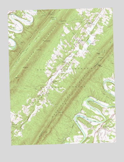
Rileyville, VA USGS Topographic Map
Click on map above to begin viewing in our Map Viewer.

This topographic map contains these locations and features:
Feature Name Type Latitude Longitude GNIS ID View Map
Buck RunStreamN38.8018°W78.4608°1482122View Map
Camp LuptonLocaleN38.8665°W78.4908°1482264View Map
CarmelPopulated PlaceN38.8271°W78.4322°1499216View Map
Chalybeate SpringSpringN38.8332°W78.3903°1482442View Map
Chapman DamDamN38.8493°W78.4995°1482451View Map
Chapman DamDamN38.8493°W78.4990°1490844View Map
Chapman ReservoirReservoirN38.8493°W78.4995°1490845View Map
DetrickPopulated PlaceN38.8454°W78.4147°1499338View Map
District 4CivilN38.8498°W78.4384°1927254View Map
Dry RunStreamN38.8609°W78.3972°1483138View Map
Dry Run ChurchChurchN38.8587°W78.4011°1483147View Map
Fort Valley ChurchChurchN38.8604°W78.3989°1483501View Map
Fort Valley Elementary SchoolSchoolN38.8476°W78.4178°1483504View Map
Fort Valley OverlookLocaleN38.8721°W78.4464°1483502View Map
Fort Valley Post OfficePost OfficeN38.8453°W78.4159°2766458View Map
Fosters LandingLocaleN38.7701°W78.4225°1499444View Map
Golladays GapGapN38.8221°W78.4839°1483689View Map
Goods FallsFallsN38.7737°W78.4103°1483700View Map
Goods LandingLocaleN38.7698°W78.3933°1488666View Map
Goods MillPopulated PlaceN38.7704°W78.4047°1499482View Map
Habron GapGapN38.7798°W78.4422°1483878View Map
High Cliff Come CampLocaleN38.7748°W78.3920°1488665View Map
Indian Grave RidgeRidgeN38.7901°W78.3806°1484329View Map
Jacks NotchGapN38.7615°W78.4620°1484383View Map
Jeremys RunStreamN38.7687°W78.3917°1484421View Map
Joppa ChurchChurchN38.7651°W78.4870°1484509View Map
Keyser PathTrailN38.7751°W78.4356°1484577View Map
Kings CrossingPopulated PlaceN38.7693°W78.4986°1499628View Map
Little Fort Recreation AreaParkN38.8671°W78.4433°1484904View Map
Massanutten Mountain TrailTrailN38.7840°W78.4381°1485215View Map
Milford GapGapN38.8293°W78.3875°1485397View Map
Moody CreekStreamN38.7529°W78.3942°1485529View Map
Mount Zion ChurchChurchN38.7971°W78.4553°1485673View Map
Munch CemeteryCemeteryN38.8515°W78.4006°1485771View Map
Nelson RunStreamN38.7648°W78.3903°1485825View Map
Oak Hill ChurchChurchN38.8429°W78.4164°1485940View Map
Opechee PeakSummitN38.8126°W78.4931°1485981View Map
Peters Mill RunStreamN38.8359°W78.4175°1486165View Map
Powell Mountain TrailTrailN38.8315°W78.4858°1486408View Map
Red Spring GapGapN38.8459°W78.4572°1486542View Map
RileyvillePopulated PlaceN38.7651°W78.3881°1499961View Map
Rileyville CemeteryCemeteryN38.7662°W78.3858°1674001View Map
Rileyville Post OfficePost OfficeN38.7626°W78.3856°2766279View Map
Riverview CemeteryCemeteryN38.8745°W78.4925°1486643View Map
Saint David ChurchChurchN38.8018°W78.4539°1673903View Map
Saint Davids ChurchChurchN38.8084°W78.4489°1486848View Map
Seak Ford LandingLocaleN38.7857°W78.3900°1488664View Map
Seven BendsBendN38.8696°W78.4800°1487002View Map
Seven FountainsPopulated PlaceN38.8612°W78.3995°1500055View Map
Seven Fountains DamDamN38.8452°W78.4022°1490840View Map
Seven Fountains LakeReservoirN38.8442°W78.4033°1490841View Map
Shenandoah County Fire and Rescue Station 14 - Fort Valley Volunteer Fire DepartmentBuildingN38.8441°W78.4159°2085912View Map
Stage HillSummitN38.7712°W78.4853°1500148View Map
Trinity ChurchChurchN38.8621°W78.4003°1487989View Map
Walters GapGapN38.8382°W78.4672°1488179View Map
White ChapelChurchN38.8459°W78.4167°1488283View Map
Woodstock GapGapN38.8637°W78.4367°1488482View Map
Woodstock Lookout TowerTowerN38.8707°W78.4486°1491298View Map
Woodstock Recreational AreaParkN38.8626°W78.4370°1673950View Map
Woodstock ReservoirReservoirN38.8454°W78.4857°1488483View Map

Note: Coordinates in the location and feature list above are referenced to NAD83 datum.


Copyright (C) 2008-2024 Ryan Niemi / Sunset Dynamics ... All Rights Reserved