TopoQuest Logo
Do you find TopoQuest useful?
Help keep TopoQuest running and adding new maps/features by donating!
Bitcoin:  19c7KJd3qBynnjoSw5npx9KScwjBe4ifkT
Litecoin:  LXs6TkuXGGXo1vDsWCkWVdjQX94eUKd6ui
Home View Maps Find Maps Find Places Resources & Links


Richardson Cove, Tennessee Topographic Map

USGS Map Title: Richardson Cove, TN
USGS Map MRC: 35083G4
DRG (GeoTIFF) Download: o35083g4.tif


Neighboring USGS Topographic Map Quads:


  Douglas Dam, TN  
35083H5
 

  Shady Grove, TN  
35083H4
 

  Chestnut Hill, TN  
35083H3
 

  Pigeon Forge, TN  
35083G5
 

  Richardson Cove, TN  
35083G4
 

  Jones Cove, TN  
35083G3
 

  Gatlinburg, TN  
35083F5
 

  Mount Le Conte, TN  
35083F4
 

  Mount Guyot, TN  
35083F3


Map MRC Location:

N36°
W84°
N36°
W83°
H8 H7 H6 H5 H4 H3 H2 H1
G8 G7 G6 G5 G4 G3 G2 G1
F8 F7 F6 F5 F4 F3 F2 F1
E8 E7 E6 E5 E4 E3 E2 E1
D8 D7 D6 D5 D4 D3 D2 D1
C8 C7 C6 C5 C4 C3 C2 C1
B8 B7 B6 B5 B4 B3 B2 B1
A8 A7 A6 A5 A4 A3 A2 A1
N35°
W84°
N35°
W83°

Richardson Cove, TN USGS 1:24K Topographic Map Preview:
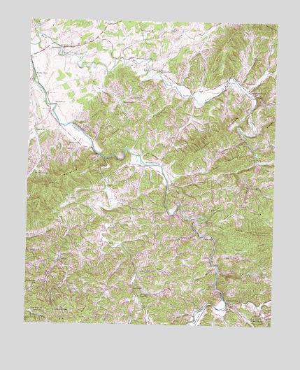
Richardson Cove, TN USGS Topographic Map
Click on map above to begin viewing in our Map Viewer.

This topographic map contains these locations and features:
Feature Name Type Latitude Longitude GNIS ID View Map
Atchley BranchStreamN35.8476°W83.4252°1275962View Map
Ball CemeteryCemeteryN35.8498°W83.3979°1276232View Map
Bearwallow MountainSummitN35.8257°W83.4099°1305029View Map
Bethany ChurchChurchN35.8451°W83.3854°1277084View Map
Bethel Baptist ChurchChurchN35.8551°W83.4399°1305139View Map
Bethel CemeteryCemeteryN35.8559°W83.4399°1645384View Map
Big Ridge CemeteryCemeteryN35.7559°W83.4796°1645385View Map
Big Ridge SchoolSchoolN35.7559°W83.4963°1277373View Map
Bird CreekStreamN35.8187°W83.4616°1277503View Map
Boogertown GapGapN35.7659°W83.4943°1277963View Map
Breeden BranchStreamN35.8545°W83.3793°1278271View Map
Brown Mare BranchStreamN35.7890°W83.4782°1278595View Map
Campbell BranchStreamN35.7712°W83.4438°1279420View Map
Canupp BranchStreamN35.8451°W83.4138°1279625View Map
CatonPopulated PlaceN35.8004°W83.4507°1314799View Map
Caton ChurchChurchN35.8006°W83.4507°1323349View Map
Catons Chapel - Richardson Cove Volunteer Fire DepartmentBuildingN35.8152°W83.4476°2654471View Map
Catons Chapel CemeteryCemeteryN35.8018°W83.4532°1645390View Map
Catons Chapel Elementary SchoolSchoolN35.8023°W83.4549°1323350View Map
Cedar BluffPopulated PlaceN35.8545°W83.4349°1279996View Map
Cedar Bluff School (historical)SchoolN35.8537°W83.4338°1323351View Map
Cedar Bluff United Methodist ChurchChurchN35.8551°W83.4332°1645391View Map
Clark BranchStreamN35.8326°W83.4779°1280587View Map
Cloverfield BranchStreamN35.8154°W83.4385°1280783View Map
Commissioner District 1CivilN35.8252°W83.3873°2464283View Map
Copeland CreekStreamN35.7581°W83.3977°1269492View Map
Cowden HollowValleyN35.8249°W83.4675°1281467View Map
CrockettsvillePopulated PlaceN35.8454°W83.3852°1647672View Map
Crockettsville SchoolSchoolN35.8462°W83.3871°1281652View Map
Cummings Chapel CemeteryCemeteryN35.8715°W83.4438°1645398View Map
Cummings ChurchChurchN35.8712°W83.4438°1306235View Map
Dixon BranchStreamN35.8420°W83.4152°1282517View Map
Dugan BranchStreamN35.8440°W83.4163°1283089View Map
Dunn CreekStreamN35.8440°W83.3860°1283206View Map
Dunn Creek Division (historical)CensusN35.8151°W83.3860°1648948View Map
East ForkPopulated PlaceN35.8451°W83.4174°1314996View Map
East Fork MineMineN35.8276°W83.3949°1652076View Map
East Prong Bird CreekStreamN35.7576°W83.4399°1283391View Map
Emerts CoveValleyN35.7591°W83.4063°1269565View Map
Emerts Cove CemeteryCemeteryN35.7534°W83.4132°1645405View Map
Evans ChapelChurchN35.8001°W83.3924°1283905View Map
Evans Chapel CemeteryCemeteryN35.8006°W83.3918°1645406View Map
Evans Chapel SchoolSchoolN35.7984°W83.3996°1283906View Map
Fern BranchStreamN35.7659°W83.4035°1284214View Map
Flat BranchStreamN35.7876°W83.4785°1284367View Map
Grassy BranchStreamN35.7748°W83.4040°1285877View Map
Grassy CemeteryCemeteryN35.7684°W83.4168°1645412View Map
Green CemeteryCemeteryN35.7787°W83.4043°1645413View Map
Griffin BranchStreamN35.7968°W83.4207°1286264View Map
Happy HollowValleyN35.7814°W83.3993°1286763View Map
Harbin HollowValleyN35.8422°W83.4535°1286793View Map
HarrisburgPopulated PlaceN35.8637°W83.4838°1306548View Map
Harrisburg Covered BridgeBridgeN35.8609°W83.4824°1323375View Map
Harrisburg School (historical)SchoolN35.8631°W83.4827°1323376View Map
Headrick CemeteryCemeteryN35.7545°W83.4007°1645417View Map
Henry BranchStreamN35.7929°W83.4102°1287435View Map
Howard-Campbell CemeteryCemeteryN35.8340°W83.4177°1645423View Map
Johnson BranchStreamN35.7837°W83.4038°1306629View Map
Lane Hollow BranchStreamN35.8693°W83.4966°1290610View Map
LaurelPopulated PlaceN35.7770°W83.4057°1315355View Map
Laurel BranchStreamN35.7723°W83.4015°1290709View Map
Laurel Branch Baptist ChurchChurchN35.7756°W83.4046°1645432View Map
Laurel SchoolSchoolN35.7868°W83.4096°1290761View Map
Licklog HollowValleyN35.8417°W83.4282°1291252View Map
Lindsey CreekStreamN35.7590°W83.3935°1306689View Map
Locust RidgeRidgeN35.7968°W83.3806°1291799View Map
Lone BranchStreamN35.8487°W83.4968°1291837View Map
Long BranchStreamN35.8437°W83.3863°1291903View Map
Long FordCrossingN35.8193°W83.4632°1315432View Map
Loveday CemeteryCemeteryN35.8637°W83.4610°1645437View Map
Maple BranchStreamN35.8565°W83.4691°1292613View Map
Maple Branch SchoolSchoolN35.8420°W83.4521°1306722View Map
Maples Branch Baptist ChurchChurchN35.8420°W83.4518°1645439View Map
Marion Green CemeteryCemeteryN35.7539°W83.3794°2775272View Map
Martin CemeteryCemeteryN35.8031°W83.4065°1292805View Map
Mill BranchStreamN35.8090°W83.4288°1293798View Map
Mize BranchStreamN35.8176°W83.3843°1294122View Map
Murphy ChapelChurchN35.8520°W83.4968°1323398View Map
Murphy Chapel CemeteryCemeteryN35.8514°W83.4958°1645452View Map
Nuns CoveValleyN35.8696°W83.4225°1296028View Map
Obes BranchStreamN35.8490°W83.3935°1296221View Map
OldhamPopulated PlaceN35.7762°W83.4821°1315651View Map
Oldham CreekStreamN35.7990°W83.4641°1296401View Map
Oldhams Creek Baptist ChurchChurchN35.7765°W83.4829°1645457View Map
Oldhams Creek School (historical)SchoolN35.7765°W83.4827°1323402View Map
Pittman CenterPopulated PlaceN35.7593°W83.3960°1297748View Map
Pittman Center Elementary SchoolSchoolN35.7590°W83.3943°1323411View Map
Powdermill CreekStreamN35.7818°W83.4552°1306920View Map
Red Bank CemeteryCemeteryN35.8404°W83.4857°1645465View Map
Red Bank ChurchChurchN35.8401°W83.4866°1306945View Map
Richardson CovePopulated PlaceN35.8159°W83.4335°1315804View Map
Richardson Cove CemeteryCemeteryN35.8184°W83.4329°1645467View Map
Richardsons Cove Baptist ChurchChurchN35.8148°W83.4379°1645466View Map
Richardsons Cove School (historical)SchoolN35.8154°W83.4316°1323414View Map
Roberts CemeteryCemeteryN35.8298°W83.4954°1645468View Map
Roberts SchoolSchoolN35.8304°W83.4963°1299653View Map
Roberts United Methodist ChurchChurchN35.8301°W83.4954°1645469View Map
Sand MountainSummitN35.8268°W83.4589°1300673View Map
Schoolhouse GapGapN35.7559°W83.4863°1300889View Map
Seaton SpringPopulated PlaceN35.8115°W83.4957°1315885View Map
Seaton TopSummitN35.8064°W83.4906°1301004View Map
Sevier County Highway Department QuarryMineN35.8736°W83.4814°2633404View Map
Shady Baptist ChurchChurchN35.7843°W83.4616°1645475View Map
Shady GrovePopulated PlaceN35.7840°W83.4616°1315903View Map
Shady Grove CemeteryCemeteryN35.7843°W83.4632°1645477View Map
Shady School (historical)SchoolN35.7823°W83.4507°1323429View Map
Sharp BranchStreamN35.8556°W83.4393°1301249View Map
Shell MountainSummitN35.8698°W83.3976°1270005View Map
Shields MountainSummitN35.8065°W83.4906°1270062View Map
Short MountainSummitN35.8177°W83.3996°1270209View Map
Sloan BranchStreamN35.8298°W83.4968°1270533View Map
Smoky Mountain AcademySchoolN35.7631°W83.4421°1303698View Map
Soak Ash CreekStreamN35.7573°W83.3810°1303709View Map
Splitwood BranchStreamN35.8079°W83.3874°1271017View Map
Swader HollowValleyN35.7958°W83.4354°1271913View Map
Tattle BranchStreamN35.8248°W83.4674°1313013View Map
Tattle BranchStreamN35.7840°W83.4599°1272172View Map
The ShinboneCliffN35.8309°W83.4752°1272439View Map
Thomas CemeteryCemeteryN35.8501°W83.3852°1272479View Map
Thomas CemeteryCemeteryN35.8323°W83.3838°1645486View Map
Town of Pittman CenterCivilN35.7595°W83.3885°2407129View Map
Turkeypen BranchStreamN35.7887°W83.4135°1304197View Map
Tyrant BranchStreamN35.7731°W83.4432°1273152View Map
Webb CreekStreamN35.7595°W83.3977°1274027View Map
West Prong Bird CreekStreamN35.7501°W83.4466°1274216View Map
Wilhite CreekStreamN35.8456°W83.3893°1274579View Map
Williams CemeteryCemeteryN35.8595°W83.3871°1274660View Map
Williams Fall ChurchChurchN35.7979°W83.4468°1274697View Map
Wilson BranchStreamN35.7768°W83.4824°1274790View Map
WMYU-FM (Sevierville)TowerN35.7973°W83.4943°1640066View Map
Zion GrovePopulated PlaceN35.7626°W83.4421°1647684View Map
Zion Grove CemeteryCemeteryN35.7637°W83.4346°1645508View Map
Zion Grove ChurchChurchN35.7634°W83.4410°1304729View Map

Note: Coordinates in the location and feature list above are referenced to NAD83 datum.


Copyright (C) 2008-2024 Ryan Niemi / Sunset Dynamics ... All Rights Reserved