TopoQuest Logo
Do you find TopoQuest useful?
Help keep TopoQuest running and adding new maps/features by donating!
Bitcoin:  19c7KJd3qBynnjoSw5npx9KScwjBe4ifkT
Litecoin:  LXs6TkuXGGXo1vDsWCkWVdjQX94eUKd6ui
Home View Maps Find Maps Find Places Resources & Links


Red Level, Florida Topographic Map

USGS Map Title: Red Level, FL
USGS Map MRC: 28082H6
DRG (GeoTIFF) Download: o28082h6.tif


Neighboring USGS Topographic Map Quads:


  Withlacoochee Bay, FL  
29082A7
 

  Yankeetown, FL  
29082A6
 

  Yankeetown SE, FL  
29082A5


  Red Level, FL  
28082H6
 

  Crystal River, FL  
28082H5


  Ozello, FL  
28082G6
 

  Homosassa, FL  
28082G5


Map MRC Location:

N29°
W83°
N29°
W82°
H8 H7 H6 H5 H4 H3 H2 H1
G8 G7 G6 G5 G4 G3 G2 G1
F8 F7 F6 F5 F4 F3 F2 F1
E8 E7 E6 E5 E4 E3 E2 E1
D8 D7 D6 D5 D4 D3 D2 D1
C8 C7 C6 C5 C4 C3 C2 C1
B8 B7 B6 B5 B4 B3 B2 B1
A8 A7 A6 A5 A4 A3 A2 A1
N28°
W83°
N28°
W82°

Red Level, FL USGS 1:24K Topographic Map Preview:
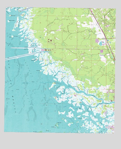
Red Level, FL USGS Topographic Map
Click on map above to begin viewing in our Map Viewer.

This topographic map contains these locations and features:
Feature Name Type Latitude Longitude GNIS ID View Map
Bennetts CreekStreamN28.9978°W82.7496°278489View Map
Big Grass IslandIslandN28.9086°W82.6998°297375View Map
Bird KeysIslandN28.8766°W82.6984°278823View Map
Black PointCapeN28.9361°W82.7098°278924View Map
Buckford CreekGutN28.9839°W82.7346°279595View Map
Burtine IslandIslandN28.9916°W82.7448°279719View Map
Camp IslandIslandN28.8978°W82.6645°279907View Map
Captain Joe IslandIslandN28.9861°W82.7468°280016View Map
Cedar CreekStreamN28.9311°W82.6932°280182View Map
Coon GapBayN28.8994°W82.6515°280751View Map
Crab CreekStreamN28.9269°W82.6845°280969View Map
Cross CreekStreamN28.9900°W82.7318°281095View Map
Crystal BayBayN28.9233°W82.7137°281114View Map
Crystal ReefBarN28.9083°W82.7476°281134View Map
Crystal RiverStreamN28.9272°W82.6970°293978View Map
Crystal River Historic MemorialParkN28.9125°W82.6465°303669View Map
Crystal River State Archaeological SiteParkN28.9094°W82.6286°1946062View Map
Deer CreekStreamN28.9133°W82.6490°281436View Map
Demory GapChannelN28.9630°W82.7448°281497View Map
Dixie BayBayN28.8772°W82.6374°281602View Map
Dolphin CreekStreamN28.9175°W82.6645°281669View Map
Double Barrel CreekStreamN28.9530°W82.7170°281691View Map
Drum IslandIslandN28.9705°W82.7418°281776View Map
East PassChannelN28.9950°W82.7479°282012View Map
Everett IslandIslandN28.9919°W82.7304°282292View Map
Fort IslandIslandN28.9103°W82.6923°282687View Map
Fort Island BeachBeachN28.9075°W82.6904°2025457View Map
Gomez CreekStreamN28.9233°W82.6770°283164View Map
Johns CreekStreamN28.9975°W82.7418°284851View Map
Kings CreekStreamN28.9169°W82.6595°285119View Map
Little Coon GapBayN28.9013°W82.6532°285645View Map
Little Rocky CreekStreamN28.9669°W82.7276°285795View Map
Little South PassBayN28.9164°W82.6824°285823View Map
Long PointCapeN28.9597°W82.7254°286038View Map
Lutrell IslandIslandN28.9836°W82.7373°286222View Map
Mount Olive ChurchChurchN28.9878°W82.6376°287260View Map
Mullet KeyIslandN28.8811°W82.6923°287457View Map
Needle Grass IslandIslandN28.9230°W82.6901°2025454View Map
Negro IslandIslandN28.9489°W82.7134°287575View Map
Pine IslandIslandN28.9058°W82.6645°288860View Map
Red LevelPopulated PlaceN28.9697°W82.6362°294904View Map
Red Level CemeteryCemeteryN28.9530°W82.6370°289548View Map
Richardson CreekStreamN28.9939°W82.7346°289677View Map
Rocky CoveBayN28.9564°W82.7247°289880View Map
Rocky CreekStreamN28.9603°W82.7232°289886View Map
Rocky IslandIslandN28.9239°W82.6895°2025453View Map
Salt CreekStreamN28.9408°W82.7084°290426View Map
Sandy HookCapeN28.8847°W82.6895°290619View Map
Shark PointCapeN28.8758°W82.7123°290930View Map
Sheephead CreekStreamN28.9141°W82.6548°291005View Map
Shell IslandIslandN28.9225°W82.6959°290976View Map
Snake IslandIslandN28.9211°W82.6923°2025455View Map
South PassChannelN28.9216°W82.6895°291403View Map
Spice KeyIslandN28.8897°W82.6607°291501View Map
The RocksLocaleN28.9100°W82.6415°294344View Map
Tin Pan GapChannelN28.9425°W82.7340°292308View Map
Tony CreekBayN28.9466°W82.7083°292358View Map
Trout CreekStreamN28.9955°W82.7368°292470View Map
Wash IslandIslandN28.9216°W82.6732°292899View Map
West Fort Island TrailTrailN28.9066°W82.6882°2025456View Map

Note: Coordinates in the location and feature list above are referenced to NAD83 datum.


Copyright (C) 2008-2024 Ryan Niemi / Sunset Dynamics ... All Rights Reserved