TopoQuest Logo
Do you find TopoQuest useful?
Help keep TopoQuest running and adding new maps/features by donating!
Bitcoin:  19c7KJd3qBynnjoSw5npx9KScwjBe4ifkT
Litecoin:  LXs6TkuXGGXo1vDsWCkWVdjQX94eUKd6ui
Home View Maps Find Maps Find Places Resources & Links


Red Basin, Idaho Topographic Map

USGS Map Title: Red Basin, ID
USGS Map MRC: 42116C7
DRG (GeoTIFF) Download: o42116c7.tif


Neighboring USGS Topographic Map Quads:


  Bedstead Ridge, ID  
42116D8
 

  Smith Creek, ID  
42116D7
 

  Castro Table, ID  
42116D6
 

  Bull Basin Camp, ID  
42116C8
 

  Red Basin, ID  
42116C7
 

  Brace Flat, ID  
42116C6
 

  Spring Creek Basin, ID  
42116B8
 

  Grassy Ridge, ID  
42116B7
 

  Piute Basin West, ID  
42116B6


Map MRC Location:

N43°
W117°
N43°
W116°
H8 H7 H6 H5 H4 H3 H2 H1
G8 G7 G6 G5 G4 G3 G2 G1
F8 F7 F6 F5 F4 F3 F2 F1
E8 E7 E6 E5 E4 E3 E2 E1
D8 D7 D6 D5 D4 D3 D2 D1
C8 C7 C6 C5 C4 C3 C2 C1
B8 B7 B6 B5 B4 B3 B2 B1
A8 A7 A6 A5 A4 A3 A2 A1
N42°
W117°
N42°
W116°

Red Basin, ID USGS 1:24K Topographic Map Preview:
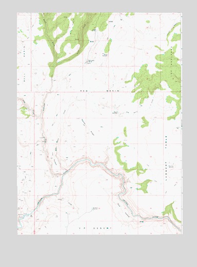
Red Basin, ID USGS Topographic Map
Click on map above to begin viewing in our Map Viewer.

This topographic map contains these locations and features:
Feature Name Type Latitude Longitude GNIS ID View Map
Big Bend ReservoirReservoirN42.2646°W116.8181°371480View Map
Big TreeRidgeN42.3666°W116.8329°371536View Map
Chilly GulchValleyN42.2724°W116.8465°371996View Map
Craig SpringSpringN42.3652°W116.8152°372234View Map
Crutcher CrossingLocaleN42.2599°W116.8701°397598View Map
Defeat RidgeRidgeN42.3074°W116.8226°372375View Map
Dougal WaterholeSpringN42.3188°W116.7993°372445View Map
East Fork Red CanyonValleyN42.3454°W116.8482°372559View Map
Flat Top ReservoirReservoirN42.2886°W116.7605°372727View Map
Lambert TableSummitN42.3102°W116.7543°397846View Map
Petes CreekStreamN42.3166°W116.8576°374379View Map
Potter ReservoirReservoirN42.3512°W116.8064°374524View Map
Rattlesnake SpringSpringN42.3475°W116.8214°374594View Map
Red BasinBasinN42.3310°W116.8123°374612View Map
Red Basin CreekStreamN42.2857°W116.8379°374613View Map
Red CanyonValleyN42.2841°W116.8404°374615View Map
Ryan PastureFlatN42.2641°W116.7957°374819View Map
The BadlandsSlopeN42.3449°W116.7579°375456View Map
The GardenLocaleN42.3043°W116.8562°375467View Map
The TongueSummitN42.2932°W116.8482°398236View Map
West Fork Red CanyonValleyN42.3454°W116.8482°375814View Map

Note: Coordinates in the location and feature list above are referenced to NAD83 datum.


Copyright (C) 2008-2024 Ryan Niemi / Sunset Dynamics ... All Rights Reserved