TopoQuest Logo
Do you find TopoQuest useful?
Help keep TopoQuest running and adding new maps/features by donating!
Bitcoin:  19c7KJd3qBynnjoSw5npx9KScwjBe4ifkT
Litecoin:  LXs6TkuXGGXo1vDsWCkWVdjQX94eUKd6ui
Home View Maps Find Maps Find Places Resources & Links


Raynor, Virginia Topographic Map

USGS Map Title: Raynor, VA
USGS Map MRC: 36076H7
DRG (GeoTIFF) Download: o36076h7.tif


Neighboring USGS Topographic Map Quads:


  Dendron, VA  
37076A8
 

  Runnymede, VA  
37076A7
 

  Bacons Castle, VA  
37076A6
 

  Ivor, VA  
36076H8
 

  Raynor, VA  
36076H7
 

  Smithfield, VA  
36076H6
 

  Sedley, VA  
36076G8
 

  Zuni, VA  
36076G7
 

  Windsor, VA  
36076G6


Map MRC Location:

N37°
W77°
N37°
W76°
H8 H7 H6 H5 H4 H3 H2 H1
G8 G7 G6 G5 G4 G3 G2 G1
F8 F7 F6 F5 F4 F3 F2 F1
E8 E7 E6 E5 E4 E3 E2 E1
D8 D7 D6 D5 D4 D3 D2 D1
C8 C7 C6 C5 C4 C3 C2 C1
B8 B7 B6 B5 B4 B3 B2 B1
A8 A7 A6 A5 A4 A3 A2 A1
N36°
W77°
N36°
W76°

Raynor, VA USGS 1:24K Topographic Map Preview:
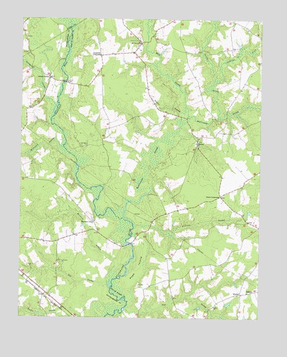
Raynor, VA USGS Topographic Map
Click on map above to begin viewing in our Map Viewer.

This topographic map contains these locations and features:
Feature Name Type Latitude Longitude GNIS ID View Map
Broadwater BridgeBridgeN36.9063°W76.8172°1739986View Map
Comet SwampStreamN36.9907°W76.7505°1465140View Map
Goodwin School (historical)SchoolN36.9818°W76.7888°1739997View Map
Gwaltney CrossroadsPopulated PlaceN36.9879°W76.7650°1739998View Map
Hickaneck SwampStreamN36.9460°W76.8522°1467973View Map
Johnson CornerPopulated PlaceN36.9754°W76.8600°1477447View Map
McClelland School (historical)SchoolN36.9624°W76.8325°1740008View Map
Mill SwampStreamN36.9596°W76.7877°1470549View Map
Mill Swamp CemeteryCemeteryN36.9890°W76.8141°1740009View Map
Mill Swamp ChurchChurchN36.9899°W76.8130°1470550View Map
Pig SwampStreamN36.8874°W76.8269°1472288View Map
Pinegrove TabernacleChurchN36.8857°W76.7558°1472378View Map
Pope IslandIslandN36.8954°W76.8127°1472626View Map
Pope SwampStreamN36.8768°W76.8211°1474268View Map
Pouches SwampStreamN36.9593°W76.7716°1472720View Map
Proctors BridgeBridgeN36.9735°W76.8519°1472801View Map
Rattlesnake SwampStreamN36.9149°W76.8161°1473019View Map
RaynorPopulated PlaceN36.9482°W76.7827°1477664View Map
Shiloh ChurchChurchN36.8796°W76.7727°1474502View Map
Stallings CreekStreamN36.9743°W76.7738°1475058View Map
Stotts CrossroadsPopulated PlaceN36.9263°W76.7702°1477785View Map
Sycamore CrossroadsPopulated PlaceN36.9851°W76.8336°1477799View Map
Terrapin SwampStreamN36.9635°W76.8569°1475542View Map
Timber SwampStreamN36.9632°W76.7894°1475728View Map
Villines SwampStreamN36.9126°W76.8150°1476191View Map
Warwick BranchStreamN36.8929°W76.8272°1476350View Map
Warwick CornerPopulated PlaceN36.9154°W76.8366°1477860View Map
WhitleyPopulated PlaceN36.8854°W76.7594°1477874View Map

Note: Coordinates in the location and feature list above are referenced to NAD83 datum.


Copyright (C) 2008-2024 Ryan Niemi / Sunset Dynamics ... All Rights Reserved