TopoQuest Logo
Do you find TopoQuest useful?
Help keep TopoQuest running and adding new maps/features by donating!
Bitcoin:  19c7KJd3qBynnjoSw5npx9KScwjBe4ifkT
Litecoin:  LXs6TkuXGGXo1vDsWCkWVdjQX94eUKd6ui
Home View Maps Find Maps Find Places Resources & Links


Big Dutch Hollow, Utah Topographic Map

USGS Map Title: Big Dutch Hollow, UT
USGS Map MRC: 40111G5
DRG (GeoTIFF) Download: o40111g5.tif


Neighboring USGS Topographic Map Quads:


  Porterville, UT  
40111H6
 

  East Canyon Reservoir, UT  
40111H5
 

  Coalville, UT  
40111H4
 

  Mountain Dell, UT  
40111G6
 

  Big Dutch Hollow, UT  
40111G5
 

  Wanship, UT  
40111G4
 

  Mount Aire, UT  
40111F6
 

  Park City West, UT  
40111F5
 

  Park City East, UT  
40111F4


Map MRC Location:

N41°
W112°
N41°
W111°
H8 H7 H6 H5 H4 H3 H2 H1
G8 G7 G6 G5 G4 G3 G2 G1
F8 F7 F6 F5 F4 F3 F2 F1
E8 E7 E6 E5 E4 E3 E2 E1
D8 D7 D6 D5 D4 D3 D2 D1
C8 C7 C6 C5 C4 C3 C2 C1
B8 B7 B6 B5 B4 B3 B2 B1
A8 A7 A6 A5 A4 A3 A2 A1
N40°
W112°
N40°
W111°

Big Dutch Hollow, UT USGS 1:24K Topographic Map Preview:
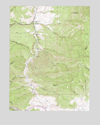
Big Dutch Hollow, UT USGS Topographic Map
Click on map above to begin viewing in our Map Viewer.

This topographic map contains these locations and features:
Feature Name Type Latitude Longitude GNIS ID View Map
AltusPopulated PlaceN40.7524°W111.6183°1437484View Map
Basin CanyonValleyN40.7716°W111.5077°1425311View Map
Bauchmanns Pony Express Station Historical MarkerParkN40.8566°W111.5891°1425325View Map
Big Bear HollowValleyN40.7899°W111.5977°1425456View Map
Big Dutch HollowValleyN40.8541°W111.5869°1425485View Map
Bitner SpringSpringN40.8116°W111.5083°1454672View Map
Camp Clayton Historical MarkerParkN40.8411°W111.5846°1426304View Map
Deer HollowValleyN40.8097°W111.5924°1427308View Map
Dry HollowValleyN40.8083°W111.5980°1440654View Map
GogorzaPopulated PlaceN40.7538°W111.5696°1437568View Map
Jeremy RanchPopulated PlaceN40.7541°W111.5594°1435770View Map
Kimball CanyonValleyN40.7577°W111.5074°1429346View Map
Kurzy HollowValleyN40.8686°W111.5844°1429395View Map
Left Fork Little Dutch HollowValleyN40.8544°W111.6146°1442507View Map
Little Dutch HollowValleyN40.8561°W111.5894°1442709View Map
Little Emigration CanyonValleyN40.8147°W111.5874°1442715View Map
Macfarlane RanchLocaleN40.8541°W111.5841°1430029View Map
Mill HollowValleyN40.7730°W111.5899°1430330View Map
Mormon Flat Historical MarkerParkN40.8149°W111.5852°1430489View Map
North Fork Big Bear HollowValleyN40.7841°W111.6210°1443889View Map
North Snyderville Basin Census Designated PlaceCensusN40.7584°W111.5127°2408948View Map
Park City Fire District Station 32BuildingN40.7511°W111.6209°2627234View Map
Parleys SummitSummitN40.7516°W111.6224°1431119View Map
Porcupine CreekStreamN40.7758°W111.5883°1431412View Map
Porcupine PeakSummitN40.8669°W111.5249°1431416View Map
Quaking Asp CreekStreamN40.8419°W111.5860°1444685View Map
Road CanyonValleyN40.7580°W111.5055°1431867View Map
Schuster CreekStreamN40.8227°W111.5760°1427542View Map
Schuster CreekStreamN40.8244°W111.5858°1432276View Map
Sheep CreekStreamN40.8522°W111.5724°1432376View Map
South Fork Big Bear HollowValleyN40.7841°W111.6210°1445827View Map
The Salt BoxFlatN40.8041°W111.5135°1433416View Map
Toll CanyonValleyN40.7555°W111.5660°1446632View Map
Wet Fork Schuster CreekStreamN40.8224°W111.5763°1434137View Map
Wood HollowValleyN40.7805°W111.5944°1434447View Map

Note: Coordinates in the location and feature list above are referenced to NAD83 datum.


Copyright (C) 2008-2024 Ryan Niemi / Sunset Dynamics ... All Rights Reserved