TopoQuest Logo
Do you find TopoQuest useful?
Help keep TopoQuest running and adding new maps/features by donating!
Bitcoin:  19c7KJd3qBynnjoSw5npx9KScwjBe4ifkT
Litecoin:  LXs6TkuXGGXo1vDsWCkWVdjQX94eUKd6ui
Home View Maps Find Maps Find Places Resources & Links


Puryear, Tennessee Topographic Map

USGS Map Title: Puryear, TN
USGS Map MRC: 36088D3
DRG (GeoTIFF) Download: o36088d3.tif


Neighboring USGS Topographic Map Quads:


  Lynn Grove, KY  
36088E4
 

  Murray, KY  
36088E3
 

  New Concord, KY  
36088E2
 

  Cottage Grove, TN  
36088D4
 

  Puryear, TN  
36088D3
 

  Buchanan, TN  
36088D2
 

  Osage, TN  
36088C4
 

  Paris, TN  
36088C3
 

  West Sandy Dike, TN  
36088C2


Map MRC Location:

N37°
W89°
N37°
W88°
H8 H7 H6 H5 H4 H3 H2 H1
G8 G7 G6 G5 G4 G3 G2 G1
F8 F7 F6 F5 F4 F3 F2 F1
E8 E7 E6 E5 E4 E3 E2 E1
D8 D7 D6 D5 D4 D3 D2 D1
C8 C7 C6 C5 C4 C3 C2 C1
B8 B7 B6 B5 B4 B3 B2 B1
A8 A7 A6 A5 A4 A3 A2 A1
N36°
W89°
N36°
W88°

Puryear, TN USGS 1:24K Topographic Map Preview:
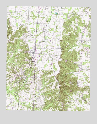
Puryear, TN USGS Topographic Map
Click on map above to begin viewing in our Map Viewer.

This topographic map contains these locations and features:
Feature Name Type Latitude Longitude GNIS ID View Map
Adams School (historical)SchoolN36.4601°W88.2675°1317278View Map
Berea Church (historical)ChurchN36.3923°W88.2956°1317285View Map
BethlehemPopulated PlaceN36.4598°W88.2637°1314674View Map
Birds CreekStreamN36.3889°W88.3592°1269270View Map
Bradley CemeteryCemeteryN36.4645°W88.3400°1278183View Map
Bradley CemeteryCemeteryN36.4673°W88.3409°1278184View Map
Carson CemeteryCemeteryN36.4575°W88.3217°1279757View Map
Chestnut Grove ChurchChurchN36.4964°W88.3184°1305888View Map
City of PuryearCivilN36.4422°W88.3326°2404580View Map
ConyersvillePopulated PlaceN36.4498°W88.2942°1314882View Map
Conyersville CemeteryCemeteryN36.4523°W88.2920°1326014View Map
Conyersville CemeteryCemeteryN36.4503°W88.2928°1326015View Map
Conyersville School (historical)SchoolN36.4498°W88.2948°1326016View Map
Cooper CemeteryCemeteryN36.4381°W88.3123°1281201View Map
Crawford CemeteryCemeteryN36.3956°W88.3431°1281579View Map
Foundary Hill School (historical)SchoolN36.4070°W88.3620°1317321View Map
Foundry HillPopulated PlaceN36.4098°W88.3550°1284708View Map
Foundry Hill CemeteryCemeteryN36.4070°W88.3628°1326037View Map
Gilliam CemeteryCemeteryN36.4081°W88.2884°1285408View Map
Gore CemeteryCemeteryN36.4398°W88.3700°1285708View Map
Hartsfield CemeteryCemeteryN36.3942°W88.3745°1287063View Map
Hendrix CemeteryCemeteryN36.4800°W88.3242°1287406View Map
Hendrix CemeteryCemeteryN36.4850°W88.3445°1287407View Map
Hickory Grove CemeteryCemeteryN36.4014°W88.2589°1287585View Map
Hooper School (historical)SchoolN36.4817°W88.2970°1317333View Map
House CemeteryCemeteryN36.3839°W88.3650°1288487View Map
House CreekStreamN36.3831°W88.3631°1647409View Map
Kennerly CemeteryCemeteryN36.4217°W88.2956°1290085View Map
Kentucky-Tennessee SpurLocaleN36.4114°W88.3473°1290094View Map
Lafever CemeteryCemeteryN36.4417°W88.2725°1326056View Map
Lankford CemeteryCemeteryN36.4614°W88.2689°1326057View Map
Latterday Saints ChurchChurchN36.4070°W88.3625°1317338View Map
Lebanon CemeteryCemeteryN36.4734°W88.3556°1326061View Map
Lebanon ChurchChurchN36.4737°W88.3559°1306674View Map
Littleton CemeteryCemeteryN36.4367°W88.3361°1326064View Map
Mandels (historical)Populated PlaceN36.4112°W88.3478°1310781View Map
Maple Grove CemeteryCemeteryN36.4200°W88.2853°1326067View Map
Mason CemeteryCemeteryN36.3998°W88.2611°1326069View Map
Mason LakeReservoirN36.4921°W88.3032°1292892View Map
Middle Fork Blood RiverStreamN36.4534°W88.2506°1293664View Map
Mormon BranchStreamN36.4706°W88.3139°1294391View Map
Morning Shade School (historical)SchoolN36.4003°W88.2942°1317354View Map
Morris CemeteryCemeteryN36.4428°W88.3245°1326068View Map
New Bethel Church (historical)ChurchN36.4001°W88.2942°1317363View Map
Old Antioch CemeteryCemeteryN36.3823°W88.3134°1296266View Map
Old Antioch Church (historical)ChurchN36.3817°W88.3128°1317375View Map
Old Foundary Hill CemeteryCemeteryN36.4162°W88.3531°1317376View Map
Old Foundry Hill ChurchChurchN36.4092°W88.3550°1317377View Map
Oliver LandingAirportN36.4129°W88.2630°2675483View Map
Overcast CemeteryCemeteryN36.4939°W88.3261°1326100View Map
Phillips CreekStreamN36.3928°W88.3612°1297356View Map
Potts CemeteryCemeteryN36.4489°W88.2925°1326115View Map
Provine CemeteryCemeteryN36.4767°W88.3498°1298613View Map
PuryearPopulated PlaceN36.4442°W88.3345°1298712View Map
Puryear CemeteryCemeteryN36.4459°W88.3436°1306931View Map
Puryear Division (historical)CensusN36.4595°W88.3203°1652460View Map
Puryear Elementary SchoolSchoolN36.4417°W88.3403°1317402View Map
Puryear First Baptist ChurchChurchN36.4459°W88.3317°1644941View Map
Puryear Memorial GardenCemeteryN36.4448°W88.3428°1326117View Map
Puryear Post OfficePost OfficeN36.4444°W88.3349°1650804View Map
Puryear SchoolSchoolN36.4339°W88.3373°1298713View Map
Puryear Volunteer Fire DepartmentBuildingN36.4441°W88.3339°2653744View Map
Rennolds CemeteryCemeteryN36.4142°W88.3273°1326118View Map
Rowe CemeteryCemeteryN36.3939°W88.3306°1300198View Map
Rowe CreekStreamN36.3831°W88.3470°1300199View Map
Rowe School (historical)SchoolN36.3939°W88.3256°1317408View Map
Scott CemeteryCemeteryN36.3973°W88.2786°1326123View Map
Shady Grove CemeteryCemeteryN36.3895°W88.2595°1326124View Map
Shady Grove ChurchChurchN36.3887°W88.2581°1301180View Map
Shady Grove School (historical)SchoolN36.3873°W88.2573°1317411View Map
Smith BranchStreamN36.4201°W88.2689°1270566View Map
Solomon School (historical)SchoolN36.4251°W88.2628°1317416View Map
Spinks SpurLocaleN36.4142°W88.3453°1271004View Map
Stephens CemeteryCemeteryN36.4812°W88.3156°1271334View Map
Thompson Grove School (historical)SchoolN36.4867°W88.3670°1317427View Map
Underwood CemeteryCemeteryN36.4717°W88.3220°1273172View Map
Union Grove CemeteryCemeteryN36.4237°W88.3456°1304238View Map
Union Grove ChurchChurchN36.4348°W88.3367°1273228View Map
Wilson CemeteryCemeteryN36.4587°W88.3720°1326156View Map

Note: Coordinates in the location and feature list above are referenced to NAD83 datum.


Copyright (C) 2008-2024 Ryan Niemi / Sunset Dynamics ... All Rights Reserved