TopoQuest Logo
Do you find TopoQuest useful?
Help keep TopoQuest running and adding new maps/features by donating!
Bitcoin:  19c7KJd3qBynnjoSw5npx9KScwjBe4ifkT
Litecoin:  LXs6TkuXGGXo1vDsWCkWVdjQX94eUKd6ui
Home View Maps Find Maps Find Places Resources & Links


Punxsutawney, Pennsylvania Topographic Map

USGS Map Title: Punxsutawney, PA
USGS Map MRC: 40078H8
DRG (GeoTIFF) Download: o40078h8.tif


Neighboring USGS Topographic Map Quads:


  Coolspring, PA  
41079A1
 

  Reynoldsville, PA  
41078A8
 

  Du Bois, PA  
41078A7
 

  Valier, PA  
40079H1
 

  Punxsutawney, PA  
40078H8
 

  McGees Mills, PA  
40078H7
 

  Marion Center, PA  
40079G1
 

  Rochester Mills, PA  
40078G8
 

  Burnside, PA  
40078G7


Map MRC Location:

N41°
W79°
N41°
W78°
H8 H7 H6 H5 H4 H3 H2 H1
G8 G7 G6 G5 G4 G3 G2 G1
F8 F7 F6 F5 F4 F3 F2 F1
E8 E7 E6 E5 E4 E3 E2 E1
D8 D7 D6 D5 D4 D3 D2 D1
C8 C7 C6 C5 C4 C3 C2 C1
B8 B7 B6 B5 B4 B3 B2 B1
A8 A7 A6 A5 A4 A3 A2 A1
N40°
W79°
N40°
W78°

Punxsutawney, PA USGS 1:24K Topographic Map Preview:
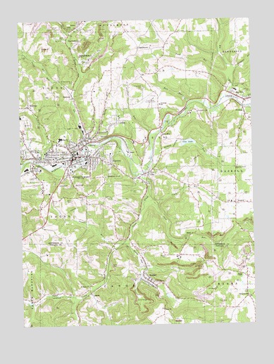
Punxsutawney, PA USGS Topographic Map
Click on map above to begin viewing in our Map Viewer.

This topographic map contains these locations and features:
Feature Name Type Latitude Longitude GNIS ID View Map
Adrian MinesPopulated PlaceN40.9848°W78.9603°1213082View Map
AlbionPopulated PlaceN40.9590°W78.9470°1168117View Map
Anita CemeteryCemeteryN40.9934°W78.9778°1168315View Map
Anita Post OfficePost OfficeN40.9972°W78.9683°2773064View Map
B and O TerminalLocaleN40.9490°W78.9545°1212863View Map
Bell Township Elementary SchoolSchoolN40.9653°W78.9242°1211632View Map
Bells MillsPopulated PlaceN40.9528°W78.9228°1169186View Map
Bells School (historical)SchoolN40.9598°W78.9223°1201145View Map
Big RunPopulated PlaceN40.9670°W78.8784°1169562View Map
Big RunStreamN40.9681°W78.8892°1169575View Map
Big Run Area Volunteer Fire Department Station 17BuildingN40.9669°W78.8781°2645460View Map
Big Run Elementary SchoolSchoolN40.9673°W78.8767°1211631View Map
Borough of Big RunCivilN40.9701°W78.8766°1215297View Map
Borough of PunxsutawneyCivilN40.9437°W78.9767°1215301View Map
Calvary CemeteryCemeteryN40.9353°W78.9925°1170918View Map
Canoe CreekStreamN40.9370°W78.9375°1171168View Map
Circle Hill CemeteryCemeteryN40.9487°W78.9495°1171879View Map
CloePopulated PlaceN40.9370°W78.9325°1172023View Map
Cloe DamDamN40.9501°W78.9131°1195174View Map
Cloe LakeReservoirN40.9496°W78.9095°1172024View Map
Cold Spring RunStreamN40.9520°W78.9645°1172159View Map
Couch RunStreamN40.9240°W78.9264°1172493View Map
Couch SchoolSchoolN40.9259°W78.9056°1201144View Map
CrawfordtownPopulated PlaceN40.9901°W78.9692°1172659View Map
Crawfordtown Delancey Post Office (historical)Post OfficeN40.9892°W78.9700°1201141View Map
De Lancey Post OfficePost OfficeN40.9845°W78.9614°1854071View Map
ElbellPopulated PlaceN40.9112°W78.9095°1203499View Map
Elk RunStreamN40.9492°W78.9645°1174126View Map
Elk Run JunctionLocaleN40.9490°W78.9545°1201138View Map
FairviewPopulated PlaceN40.9417°W78.9509°1174466View Map
FoxburgPopulated PlaceN40.9623°W78.8789°1175113View Map
Gobblers KnobSummitN40.9362°W78.9534°1175765View Map
Graffius RunStreamN40.9537°W78.9284°1175918View Map
Greenwood CemeteryCemeteryN40.9476°W78.9473°1176194View Map
Grube School (historical)SchoolN40.9731°W78.9414°1201140View Map
HarmonyPopulated PlaceN40.9684°W78.9703°1176544View Map
Hoeh SchoolSchoolN40.9170°W78.9425°1201143View Map
Jackson RunStreamN40.9462°W78.9281°1177929View Map
Jefferson County Emergency Medical Services Station 50BuildingN40.9431°W78.9818°2719671View Map
JohnsonburgPopulated PlaceN40.8862°W78.8778°1209712View Map
JuneauPopulated PlaceN40.8884°W78.9625°1203903View Map
Little Elk RunStreamN40.9748°W78.9781°1179538View Map
McCalmont Township Volunteer Fire Department Station 16BuildingN40.9961°W78.9691°2644889View Map
McKee School (historical)SchoolN40.8962°W78.8839°1201142View Map
Oak Lawn CemeteryCemeteryN40.9300°W78.9365°1182785View Map
Painter RunStreamN40.9078°W78.9473°1183205View Map
Pearce CemeteryCemeteryN40.9031°W78.9225°1183424View Map
Pleasant Grove ChurchChurchN40.9395°W78.8834°1184015View Map
PunxsutawneyPopulated PlaceN40.9437°W78.9709°1214004View Map
Punxsutawney Area HospitalHospitalN40.9610°W78.9998°2718055View Map
Punxsutawney Area Senior High SchoolSchoolN40.9515°W78.9781°1211630View Map
Punxsutawney Central Fire Department Station 20BuildingN40.9441°W78.9676°2645332View Map
Punxsutawney Fire Department Elk Run Station 30BuildingN40.9525°W78.9640°2645543View Map
Punxsutawney Fire Department Lindsey Station 40BuildingN40.9431°W78.9893°2645542View Map
Punxsutawney Municipal AirportAirportN40.9678°W78.9279°1194145View Map
Punxsutawney Police DepartmentBuildingN40.9440°W78.9680°2777310View Map
Punxsutawney Post OfficePost OfficeN40.9436°W78.9636°2772928View Map
Ridgemont CemeteryCemeteryN40.9722°W78.9328°1185049View Map
RikerPopulated PlaceN40.9459°W78.9403°1204510View Map
RobertsvillePopulated PlaceN40.9626°W78.9039°1212861View Map
Rock RunStreamN40.9662°W78.9081°1185280View Map
RossiterPopulated PlaceN40.8945°W78.9311°1185499View Map
Rossiter Census Designated PlaceCensusN40.8990°W78.9355°2389781View Map
Rossiter DamDamN40.8884°W78.9214°1195127View Map
Rossiter Post OfficePost OfficeN40.8939°W78.9337°2772952View Map
Rossiter StationLocaleN40.9109°W78.9423°1201136View Map
Rossiter Volunteer Fire Department Station 340BuildingN40.8931°W78.9309°2645719View Map
Saint Adrian CemeteryCemeteryN40.9959°W78.9803°1185725View Map
Saint Marks ChurchChurchN40.8912°W78.9636°1186332View Map
Saints Peter and Paul Byzantine CemeteryCemeteryN40.9746°W78.9707°1186802View Map
Sawmill RunStreamN40.9415°W78.9886°1187037View Map
Smith RunStreamN40.9167°W78.9206°1212864View Map
Snyder SchoolSchoolN40.9276°W78.9739°1201137View Map
SpindletownPopulated PlaceN40.9887°W78.9336°1204701View Map
Steffy ChapelChurchN40.8953°W78.8811°1188594View Map
Thomas SchoolSchoolN40.9676°W78.9606°1201139View Map
Township of BellCivilN40.9519°W78.9262°1216557View Map
Township of YoungCivilN40.9539°W78.9883°1216577View Map
Trout RunStreamN40.9759°W78.8864°1189864View Map
Trout Run School (historical)SchoolN40.9851°W78.9211°1201146View Map
Ugly RunStreamN40.9256°W78.9328°1190064View Map
Union ChurchChurchN40.8812°W78.9239°1190141View Map
WalstonPopulated PlaceN40.9651°W78.9948°1190559View Map
Walston Post OfficePost OfficeN40.9634°W78.9928°2775118View Map
West End Elementary SchoolSchoolN40.9467°W78.9900°1213927View Map
Windfall RunStreamN40.9795°W78.8831°1191575View Map
WinslowPopulated PlaceN40.9245°W78.8839°1204973View Map
WinslowLocaleN40.9178°W78.8842°1212785View Map

Note: Coordinates in the location and feature list above are referenced to NAD83 datum.


Copyright (C) 2008-2024 Ryan Niemi / Sunset Dynamics ... All Rights Reserved