TopoQuest Logo
Do you find TopoQuest useful?
Help keep TopoQuest running and adding new maps/features by donating!
Bitcoin:  19c7KJd3qBynnjoSw5npx9KScwjBe4ifkT
Litecoin:  LXs6TkuXGGXo1vDsWCkWVdjQX94eUKd6ui
Home View Maps Find Maps Find Places Resources & Links


Pulga, California Topographic Map

USGS Map Title: Pulga, CA
USGS Map MRC: 39121G4
DRG (GeoTIFF) Download: o39121g4.tif


Neighboring USGS Topographic Map Quads:


  Stirling City, CA  
39121H5
 

  Kimshew Point, CA  
39121H4
 

  Storrie, CA  
39121H3
 

  Paradise East, CA  
39121G5
 

  Pulga, CA  
39121G4
 

  Soapstone Hill, CA  
39121G3
 

  Cherokee, CA  
39121F5
 

  Berry Creek, CA  
39121F4
 

  Brush Creek, CA  
39121F3


Map MRC Location:

N40°
W122°
N40°
W121°
H8 H7 H6 H5 H4 H3 H2 H1
G8 G7 G6 G5 G4 G3 G2 G1
F8 F7 F6 F5 F4 F3 F2 F1
E8 E7 E6 E5 E4 E3 E2 E1
D8 D7 D6 D5 D4 D3 D2 D1
C8 C7 C6 C5 C4 C3 C2 C1
B8 B7 B6 B5 B4 B3 B2 B1
A8 A7 A6 A5 A4 A3 A2 A1
N39°
W122°
N39°
W121°

Pulga, CA USGS 1:24K Topographic Map Preview:
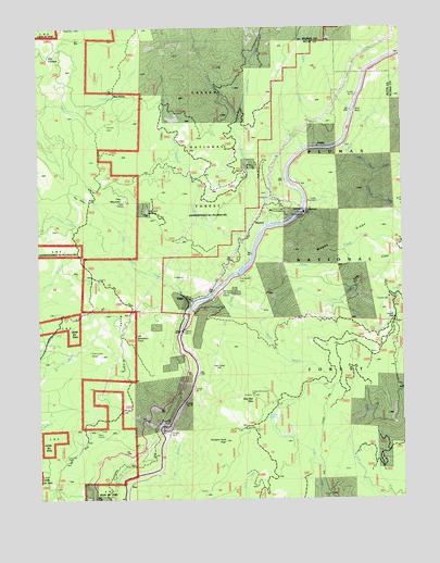
Pulga, CA USGS Topographic Map
Click on map above to begin viewing in our Map Viewer.

This topographic map contains these locations and features:
Feature Name Type Latitude Longitude GNIS ID View Map
Arch RockPillarN39.8527°W121.3916°256308View Map
Bardees BarBarN39.7682°W121.4591°256509View Map
Batchelor PointCapeN39.7932°W121.4677°256587View Map
Bear Ranch CreekStreamN39.8435°W121.3969°256695View Map
Big BarPopulated PlaceN39.8054°W121.4380°1723844View Map
Big Bar MountainSummitN39.7774°W121.4272°256877View Map
Camp CreekStreamN39.8221°W121.4219°257868View Map
Camp Creek PowerhouseLocaleN39.8268°W121.4194°276184View Map
Campbell MeadowFlatN39.8263°W121.4633°257914View Map
Cedar CreekStreamN39.8429°W121.4058°266548View Map
Coyote GapGapN39.7979°W121.3789°258834View Map
Coyote Gap Forest Service StationLocaleN39.8035°W121.3811°276513View Map
Coyote Gap Forest Service StationLocaleN39.8029°W121.3805°258835View Map
Crain MillLocaleN39.7613°W121.4922°258867View Map
CrestaPopulated PlaceN39.8435°W121.4044°1658350View Map
Cresta PowerhouseLocaleN39.8263°W121.4089°1654220View Map
Cresta TunnelTunnelN39.8471°W121.3891°258916View Map
Dogwood CreekStreamN39.8149°W121.4272°259451View Map
Fish Camp FlatFlatN39.7849°W121.4394°260143View Map
Five CornersLocaleN39.8679°W121.4969°260175View Map
Flea MountainSummitN39.8291°W121.4711°1658549View Map
Flea ValleyBasinN39.8307°W121.4839°260198View Map
Flea Valley (historical)Populated PlaceN39.8296°W121.4830°1723857View Map
Flea Valley CreekStreamN39.8021°W121.4464°266711View Map
Heinz CreekStreamN39.8141°W121.4261°261230View Map
Hibbard CreekStreamN39.8360°W121.3855°261293View Map
Hungary Hunt PeakSummitN39.7654°W121.4372°261629View Map
Hutchins Mill (historical)LocaleN39.8374°W121.4569°1723863View Map
Johnson CabinLocaleN39.8491°W121.4775°276181View Map
Lockerman CreekStreamN39.8510°W121.4305°262764View Map
Magee RidgeRidgeN39.8188°W121.3964°263116View Map
MayaroPopulated PlaceN39.8241°W121.4222°1659079View Map
Mill CreekStreamN39.8049°W121.4394°263606View Map
Mill Creek Cal-TransitLocaleN39.8046°W121.4386°276524View Map
Mill Creek Cal-Transit StationLocaleN39.8049°W121.4377°276183View Map
Old Defiance Mill (historical)LocaleN39.8563°W121.4752°1723878View Map
Pine Cluster RanchLocaleN39.7888°W121.4894°276182View Map
Poe DamDamN39.8095°W121.4324°264874View Map
Poe TunnelTunnelN39.7757°W121.4455°264875View Map
PulgaPopulated PlaceN39.8029°W121.4486°1659439View Map
Rag DumpLocaleN39.8568°W121.4747°265130View Map
Rocky RidgeRidgeN39.7916°W121.4730°265546View Map
Shady Rest AreaLocaleN39.8479°W121.3944°276522View Map
Shady Rest Receration AreaLocaleN39.8479°W121.3941°276185View Map
South Branch Mill CreekStreamN39.7968°W121.4250°267407View Map
Tunnel Number ElevenTunnelN39.7793°W121.4477°268475View Map
Tunnel Number NineTunnelN39.7668°W121.4564°268478View Map
Tunnel Number TenTunnelN39.7754°W121.4511°268474View Map
Tunnel Number ThirteenTunnelN39.8568°W121.3911°268476View Map
Wyman SpringSpringN39.7724°W121.4230°269327View Map

Note: Coordinates in the location and feature list above are referenced to NAD83 datum.


Copyright (C) 2008-2024 Ryan Niemi / Sunset Dynamics ... All Rights Reserved