TopoQuest Logo
Do you find TopoQuest useful?
Help keep TopoQuest running and adding new maps/features by donating!
Bitcoin:  19c7KJd3qBynnjoSw5npx9KScwjBe4ifkT
Litecoin:  LXs6TkuXGGXo1vDsWCkWVdjQX94eUKd6ui
Home View Maps Find Maps Find Places Resources & Links


Potato Hill, California Topographic Map

USGS Map Title: Potato Hill, CA
USGS Map MRC: 39122C7
DRG (GeoTIFF) Download: o39122c7.tif


Neighboring USGS Topographic Map Quads:


  Lake Pillsbury, CA  
39122D8
 

  Crockett Peak, CA  
39122D7
 

  Saint John Mountain, CA  
39122D6
 

  Elk Mountain, CA  
39122C8
 

  Potato Hill, CA  
39122C7
 

  Fouts Springs, CA  
39122C6
 

  Upper Lake, CA  
39122B8
 

  Bartlett Mountain, CA  
39122B7
 

  Bartlett Springs, CA  
39122B6


Map MRC Location:

N40°
W123°
N40°
W122°
H8 H7 H6 H5 H4 H3 H2 H1
G8 G7 G6 G5 G4 G3 G2 G1
F8 F7 F6 F5 F4 F3 F2 F1
E8 E7 E6 E5 E4 E3 E2 E1
D8 D7 D6 D5 D4 D3 D2 D1
C8 C7 C6 C5 C4 C3 C2 C1
B8 B7 B6 B5 B4 B3 B2 B1
A8 A7 A6 A5 A4 A3 A2 A1
N39°
W123°
N39°
W122°

Potato Hill, CA USGS 1:24K Topographic Map Preview:
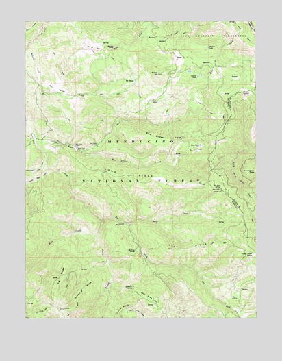
Potato Hill, CA USGS Topographic Map
Click on map above to begin viewing in our Map Viewer.

This topographic map contains these locations and features:
Feature Name Type Latitude Longitude GNIS ID View Map
Barker CreekStreamN39.3666°W122.8164°256517View Map
Bear CreekStreamN39.3249°W122.8708°256631View Map
Bear Creek CampgroundLocaleN39.3227°W122.8369°256652View Map
Bear Creek StationLocaleN39.3224°W122.8494°256654View Map
Big RidgeRidgeN39.2663°W122.8564°256993View Map
Big SpringSpringN39.3501°W122.8167°257013View Map
Blue Slides CreekStreamN39.3202°W122.8478°257281View Map
Blue Slides LakeLakeN39.3226°W122.7813°257282View Map
Blue Slides RidgeRidgeN39.3246°W122.7992°257283View Map
Catfish PondLakeN39.3513°W122.7830°258076View Map
Crabtree Hot SpringsSpringN39.2899°W122.8222°258851View Map
Dry CreekStreamN39.3446°W122.8614°259543View Map
Fir Root SpringSpringN39.3041°W122.7705°260121View Map
French CreekStreamN39.2907°W122.8347°260379View Map
Hale RidgeRidgeN39.2791°W122.7878°261014View Map
Knobcone SpringSpringN39.2632°W122.8181°262225View Map
Little Horse MountainSummitN39.2599°W122.8094°1658973View Map
Little Soda CreekStreamN39.3121°W122.8653°262728View Map
Long RidgeRidgeN39.3096°W122.8203°262878View Map
Madrone SpringSpringN39.2779°W122.8164°263112View Map
Mauser GladeFlatN39.3632°W122.8294°263273View Map
McLeod CreekStreamN39.3488°W122.8697°263403View Map
North GladeFlatN39.3635°W122.8383°264223View Map
Parramore CreekStreamN39.3141°W122.8669°264534View Map
Potato HillSummitN39.3527°W122.8039°264994View Map
Rabbit Glade SpringSpringN39.2540°W122.8583°265120View Map
Rice ValleyValleyN39.3491°W122.8664°265399View Map
Richardson GladeFlatN39.2632°W122.7511°265409View Map
Rock CreekStreamN39.2852°W122.8375°265486View Map
Salt CreekStreamN39.2888°W122.8200°265761View Map
Snow Mountain HouseLocaleN39.3416°W122.8067°267327View Map
Summit SpringSpringN39.3449°W122.7543°267946View Map
Summit Springs TrailheadLocaleN39.3457°W122.7530°277164View Map
Summit Springs Trailhead ParkingLocaleN39.3457°W122.7530°1655318View Map
Sumner RidgeRidgeN39.2627°W122.8444°267911View Map
Timber LakeLakeN39.3636°W122.7771°268286View Map
Upper Lake-Clearlake Oaks DivisionCensusN39.2685°W122.8097°1935355View Map
Youngs Corral (historical)LocaleN39.2771°W122.7525°1670517View Map
Youngs Corral SpringSpringN39.2769°W122.7527°269374View Map

Note: Coordinates in the location and feature list above are referenced to NAD83 datum.


Copyright (C) 2008-2024 Ryan Niemi / Sunset Dynamics ... All Rights Reserved