TopoQuest Logo
Do you find TopoQuest useful?
Help keep TopoQuest running and adding new maps/features by donating!
Bitcoin:  19c7KJd3qBynnjoSw5npx9KScwjBe4ifkT
Litecoin:  LXs6TkuXGGXo1vDsWCkWVdjQX94eUKd6ui
Home View Maps Find Maps Find Places Resources & Links


Plain Dealing, Louisiana Topographic Map

USGS Map Title: Plain Dealing, LA
USGS Map MRC: 32093H6
DRG (GeoTIFF) Download: o32093h6.tif


Neighboring USGS Topographic Map Quads:


  Doddridge SE, AR  
33093A7
 

  Bradley, AR  
33093A6
 

  Bradley SE, AR  
33093A5
 

  Wardview, LA  
32093H7
 

  Plain Dealing, LA  
32093H6
 

  Carterville, LA  
32093H5
 

  Gilliam, LA  
32093G7
 

  Hughes, LA  
32093G6
 

  Ivan, LA  
32093G5


Map MRC Location:

N33°
W94°
N33°
W93°
H8 H7 H6 H5 H4 H3 H2 H1
G8 G7 G6 G5 G4 G3 G2 G1
F8 F7 F6 F5 F4 F3 F2 F1
E8 E7 E6 E5 E4 E3 E2 E1
D8 D7 D6 D5 D4 D3 D2 D1
C8 C7 C6 C5 C4 C3 C2 C1
B8 B7 B6 B5 B4 B3 B2 B1
A8 A7 A6 A5 A4 A3 A2 A1
N32°
W94°
N32°
W93°

Plain Dealing, LA USGS 1:24K Topographic Map Preview:
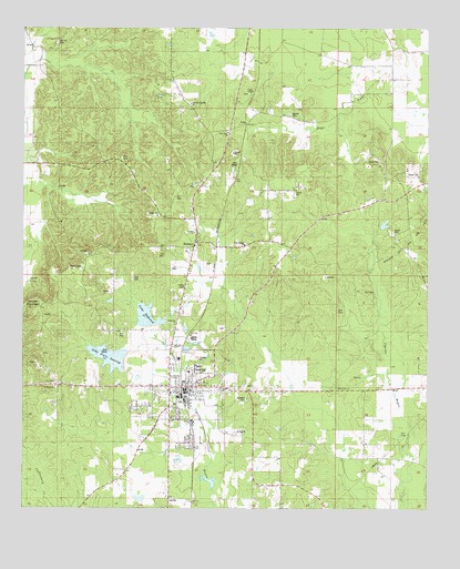
Plain Dealing, LA USGS Topographic Map
Click on map above to begin viewing in our Map Viewer.

This topographic map contains these locations and features:
Feature Name Type Latitude Longitude GNIS ID View Map
AntrimPopulated PlaceN32.8774°W93.7052°532197View Map
BolingerPopulated PlaceN32.9443°W93.6977°543004View Map
Bolinger Lookout TowerTowerN32.9401°W93.7418°558749View Map
Bolinger Oil FieldOilfieldN32.9404°W93.7091°550776View Map
Caldwell CemeteryCemeteryN32.9035°W93.6810°533620View Map
Carrie Martin Elementary SchoolSchoolN32.8978°W93.6979°550871View Map
Cypress Bayou Number OneReservoirN32.9118°W93.7168°557034View Map
Cypress Bayou Number One DamDamN32.9118°W93.7168°557033View Map
Cypress Bayou Number ThreeReservoirN32.9166°W93.6994°556743View Map
Cypress Bayou Number Three DamDamN32.9168°W93.7002°556742View Map
Cypress Bayou Number Two DamDamN32.9218°W93.7085°556744View Map
Delaney MountSummitN32.9296°W93.7471°534480View Map
Dogwood Boy Scout CampLocaleN32.9412°W93.7307°550811View Map
Ford CemeteryCemeteryN32.9351°W93.7168°535029View Map
Immanuel ChurchChurchN32.9229°W93.7030°540843View Map
Israelite ChurchChurchN32.9468°W93.6974°540844View Map
Lake DogwoodReservoirN32.9253°W93.7120°540840View Map
Lake Plain DealingReservoirN32.9145°W93.7234°540854View Map
LelaPopulated PlaceN32.9743°W93.6818°543393View Map
Macedonia ChurchChurchN32.9060°W93.6532°536800View Map
Mount Zion ChurchChurchN32.8949°W93.6818°537455View Map
Oak Grove ChurchChurchN32.9746°W93.6946°537786View Map
Oak Hill CemeteryCemeteryN32.9965°W93.7399°555527View Map
Old Rock Spring ChurchChurchN32.9801°W93.6988°537853View Map
Plain DealingPopulated PlaceN32.9051°W93.6968°538227View Map
Plain Dealing Academy SchoolSchoolN32.9139°W93.7018°2462741View Map
Plain Dealing CemeteryCemeteryN32.9221°W93.6896°538228View Map
Plain Dealing High SchoolSchoolN32.9103°W93.6992°550872View Map
Plain Dealing Lake Number Two DamDamN32.9285°W93.7118°557017View Map
Plain Dealing Lake Site Number One DamDamN32.9151°W93.7252°557016View Map
Plain Dealing Middle SchoolSchoolN32.9105°W93.6987°2462774View Map
Plain Dealing Oil FieldOilfieldN32.9682°W93.6846°555671View Map
Plain Dealing Volunteer Fire DepartmentBuildingN32.9052°W93.7024°2673086View Map
Redland Oil and Gas FieldOilfieldN32.9585°W93.6316°555781View Map
Rock Spring ChurchChurchN32.9435°W93.6818°540857View Map
Saint Marys ChurchChurchN32.9068°W93.7402°538989View Map
Salem CemeteryCemeteryN32.9468°W93.6371°539093View Map
Town of Plain DealingCivilN32.9075°W93.6991°2407131View Map
Union ChurchChurchN32.9829°W93.6805°540100View Map
Ward ThreeCivilN32.8860°W93.6885°544938View Map
Wyche CemeteryCemeteryN32.9776°W93.6691°540553View Map

Note: Coordinates in the location and feature list above are referenced to NAD83 datum.


Copyright (C) 2008-2024 Ryan Niemi / Sunset Dynamics ... All Rights Reserved