TopoQuest Logo
Do you find TopoQuest useful?
Help keep TopoQuest running and adding new maps/features by donating!
Bitcoin:  19c7KJd3qBynnjoSw5npx9KScwjBe4ifkT
Litecoin:  LXs6TkuXGGXo1vDsWCkWVdjQX94eUKd6ui
Home View Maps Find Maps Find Places Resources & Links


Piru, California Topographic Map

USGS Map Title: Piru, CA
USGS Map MRC: 34118D7
DRG (GeoTIFF) Download: o34118d7.tif


Neighboring USGS Topographic Map Quads:


  Devils Heart Peak, CA  
34118E8
 

  Cobblestone Mountain, CA  
34118E7
 

  Whitaker Peak, CA  
34118E6
 

  Fillmore, CA  
34118D8
 

  Piru, CA  
34118D7
 

  Val Verde, CA  
34118D6
 

  Moorpark, CA  
34118C8
 

  Simi Valley West, CA  
34118C7
 

  Simi Valley East, CA  
34118C6


Map MRC Location:

N35°
W119°
N35°
W118°
H8 H7 H6 H5 H4 H3 H2 H1
G8 G7 G6 G5 G4 G3 G2 G1
F8 F7 F6 F5 F4 F3 F2 F1
E8 E7 E6 E5 E4 E3 E2 E1
D8 D7 D6 D5 D4 D3 D2 D1
C8 C7 C6 C5 C4 C3 C2 C1
B8 B7 B6 B5 B4 B3 B2 B1
A8 A7 A6 A5 A4 A3 A2 A1
N34°
W119°
N34°
W118°

Piru, CA USGS 1:24K Topographic Map Preview:
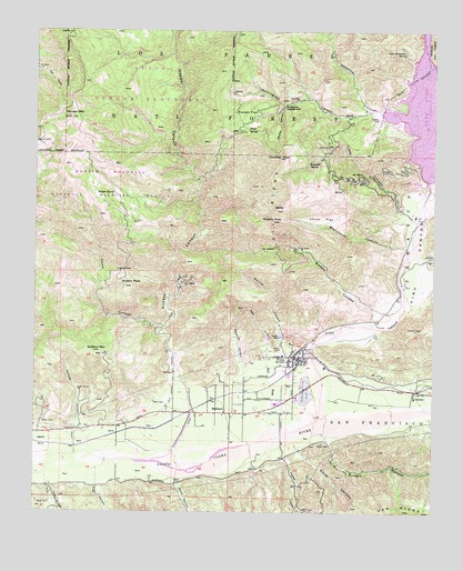
Piru, CA USGS Topographic Map
Click on map above to begin viewing in our Map Viewer.

This topographic map contains these locations and features:
Feature Name Type Latitude Longitude GNIS ID View Map
Angels PassGapN34.4381°W118.8473°269538View Map
Arundell PeakSummitN34.4675°W118.7987°269595View Map
Arundell SpringSpringN34.4660°W118.7903°269596View Map
BaldySummitN34.4536°W118.7998°269649View Map
Blanchard CanyonValleyN34.4436°W118.7587°269911View Map
BuckhornPopulated PlaceN34.4008°W118.8156°1660388View Map
Buckhorn RanchLocaleN34.4075°W118.8218°1682661View Map
Calumet CanyonValleyN34.3814°W118.8707°270168View Map
CamulosPopulated PlaceN34.4067°W118.7568°270247View Map
CavinPopulated PlaceN34.3953°W118.8495°1660450View Map
Chino FlatFlatN34.4514°W118.7856°270435View Map
Debris DamDamN34.4206°W118.7987°270788View Map
Dominguez CampgroundLocaleN34.4811°W118.7976°270895View Map
Dominguez CanyonValleyN34.4794°W118.7718°270896View Map
Dominguez RanchLocaleN34.4830°W118.7612°275534View Map
Dominguez RanchLocaleN34.4825°W118.8151°275435View Map
Dominguez RanchLocaleN34.4825°W118.7898°1682666View Map
Edwards CanyonValleyN34.4106°W118.8098°271020View Map
Eureka CanyonValleyN34.3958°W118.7854°271085View Map
Eureka Canyon Oil FieldOilfieldN34.3900°W118.7845°1870681View Map
Fairview CanyonValleyN34.3964°W118.8620°271090View Map
Fillmore DivisionCivilN34.4084°W118.8451°1935103View Map
Frey CanyonValleyN34.3814°W118.8559°271237View Map
Greenhorn CreekStreamN34.4186°W118.7987°233958View Map
Haines CanyonValleyN34.3972°W118.8745°1675761View Map
Holser CanyonValleyN34.4411°W118.7562°271610View Map
Hopper CanyonValleyN34.4075°W118.8279°271624View Map
Hopper MountainSummitN34.4778°W118.8654°271625View Map
Hopper Mountain National Wildlife RefugeParkN34.4562°W118.8538°275532View Map
Hopper Mountain Wildlife RefugeParkN34.4605°W118.8515°275425View Map
Hopper RanchLocaleN34.4581°W118.8512°271626View Map
Hutton PeakSummitN34.4339°W118.8454°271699View Map
Juan Fernandez SpringSpringN34.4946°W118.7604°271832View Map
Karlyn RanchLocaleN34.4789°W118.7856°1682671View Map
Lake PiruReservoirN34.4818°W118.7530°273032View Map
Lankersham EstateLocaleN34.4214°W118.8368°1682673View Map
Lime CanyonValleyN34.4539°W118.7609°272038View Map
Maple CanyonValleyN34.4814°W118.7970°272338View Map
Modelo CanyonValleyN34.4250°W118.7698°272514View Map
Modelo PeakSummitN34.4508°W118.8009°272515View Map
Oil RidgeRidgeN34.4486°W118.8023°272770View Map
PiruPopulated PlaceN34.4153°W118.7940°1652775View Map
Piru Branch Ventura County LibraryBuildingN34.4158°W118.7979°1870706View Map
Piru CanyonValleyN34.4019°W118.7843°273029View Map
Piru CemeteryCemeteryN34.4150°W118.8045°1870707View Map
Piru Census Designated PlaceCensusN34.4075°W118.7999°2409077View Map
Piru CreekStreamN34.3989°W118.7856°273030View Map
Piru Elementary SchoolSchoolN34.4158°W118.7979°1870708View Map
Piru Post OfficePost OfficeN34.4148°W118.7944°1870709View Map
Piru United Methodist ChurchChurchN34.4156°W118.7962°1870710View Map
Rancho Del Rey (historical)LocaleN34.4794°W118.7687°1682677View Map
Real CanyonValleyN34.4156°W118.8026°273232View Map
Real WashStreamN34.3969°W118.8018°273233View Map
Reasoner CanyonValleyN34.4789°W118.7676°273234View Map
Rodeo FlatFlatN34.4789°W118.8095°273329View Map
Rodeo SpringSpringN34.4743°W118.8094°273331View Map
San Salvador Catholic ChurchChurchN34.4156°W118.7912°1870718View Map
Santa Felicia DamDamN34.4617°W118.7512°273551View Map
Smith CanyonValleyN34.3908°W118.7923°273758View Map
Stephen RanchLocaleN34.3883°W118.7823°1682680View Map
Sulphur MountainSummitN34.4164°W118.8554°273943View Map
Temecal Division RanchLocaleN34.4347°W118.7604°1682681View Map
Temescal Forest Service StationLocaleN34.4736°W118.7612°276735View Map
Temescal Guard Station (historical)LocaleN34.4761°W118.7551°1682682View Map
Temescal School (historical)SchoolN34.4772°W118.7556°1682683View Map
Toms CanyonValleyN34.4228°W118.8359°274157View Map
Torrey CanyonValleyN34.3892°W118.7970°274168View Map
Ventura County Fire Protection District Station 28 PiruBuildingN34.4133°W118.7964°2665273View Map
Warring CanyonValleyN34.4186°W118.7987°274384View Map
Warring ParkParkN34.4169°W118.7901°274385View Map
Wiley CanyonValleyN34.3822°W118.8307°274500View Map

Note: Coordinates in the location and feature list above are referenced to NAD83 datum.


Copyright (C) 2008-2024 Ryan Niemi / Sunset Dynamics ... All Rights Reserved