TopoQuest Logo
Do you find TopoQuest useful?
Help keep TopoQuest running and adding new maps/features by donating!
Bitcoin:  19c7KJd3qBynnjoSw5npx9KScwjBe4ifkT
Litecoin:  LXs6TkuXGGXo1vDsWCkWVdjQX94eUKd6ui
Home View Maps Find Maps Find Places Resources & Links


Pine, Arizona Topographic Map

USGS Map Title: Pine, AZ
USGS Map MRC: 34111D4
DRG (GeoTIFF) Download: o34111d4.tif


Neighboring USGS Topographic Map Quads:


  Buckhorn Mountain, AZ  
34111E5
 

  Calloway Butte, AZ  
34111E4
 

  Long Valley, AZ  
34111E3
 

  Strawberry, AZ  
34111D5
 

  Pine, AZ  
34111D4
 

  Kehl Ridge, AZ  
34111D3
 

  Cane Springs Mountain, AZ  
34111C5
 

  Buckhead Mesa, AZ  
34111C4
 

  Payson North, AZ  
34111C3


Map MRC Location:

N35°
W112°
N35°
W111°
H8 H7 H6 H5 H4 H3 H2 H1
G8 G7 G6 G5 G4 G3 G2 G1
F8 F7 F6 F5 F4 F3 F2 F1
E8 E7 E6 E5 E4 E3 E2 E1
D8 D7 D6 D5 D4 D3 D2 D1
C8 C7 C6 C5 C4 C3 C2 C1
B8 B7 B6 B5 B4 B3 B2 B1
A8 A7 A6 A5 A4 A3 A2 A1
N34°
W112°
N34°
W111°

Pine, AZ USGS 1:24K Topographic Map Preview:
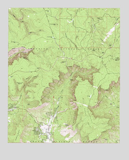
Pine, AZ USGS Topographic Map
Click on map above to begin viewing in our Map Viewer.

This topographic map contains these locations and features:
Feature Name Type Latitude Longitude GNIS ID View Map
Baker ButteSummitN34.4520°W111.3785°25895View Map
Baker LakeLakeN34.4545°W111.3967°25896View Map
Baker SpringSpringN34.4582°W111.3957°25899View Map
Camp GeronimoLocaleN34.4086°W111.3768°39316View Map
Camp Lo MiaLocaleN34.4161°W111.4438°27206View Map
Cinch Hook ButteSummitN34.4492°W111.4407°27651View Map
Corduroy WashStreamN34.4878°W111.4296°27946View Map
Corner TankReservoirN34.4381°W111.4671°37724View Map
Cottonwood SpringSpringN34.3770°W111.4771°39383View Map
Dickenson FlatFlatN34.4181°W111.4082°28470View Map
Dickenson Flat TankReservoirN34.4170°W111.4091°37744View Map
Dripping SpringsSpringN34.3909°W111.4338°28603View Map
First Baptist Church of PineChurchN34.3900°W111.4544°2670951View Map
Fivemile LakeLakeN34.4361°W111.4983°29037View Map
Fuller SpringSpringN34.4101°W111.4762°29230View Map
Garden TankReservoirN34.3806°W111.4013°37811View Map
Hicks and Duncan TankReservoirN34.4903°W111.4324°37829View Map
Horse Pasture TankReservoirN34.4680°W111.4924°30161View Map
Huffer SpringsSpringN34.4653°W111.3878°30268View Map
Milk Ranch PointCliffN34.3978°W111.4129°31857View Map
Parsnip SpringSpringN34.4336°W111.4313°32701View Map
PinePopulated PlaceN34.3845°W111.4551°32916View Map
Pine - Strawberry Fire District Station 41BuildingN34.3846°W111.4570°2672398View Map
Pine CanyonValleyN34.3886°W111.4535°32919View Map
Pine Census Designated PlaceCensusN34.3788°W111.4574°2409065View Map
Pine Post OfficePost OfficeN34.3867°W111.4543°44928View Map
Pine Ranger StationLocaleN34.3809°W111.4524°39698View Map
Pine SpringSpringN34.3785°W111.3897°9473View Map
Pine Strawberry Elementary SchoolSchoolN34.3871°W111.4571°39699View Map
Pivot Rock SpringSpringN34.4906°W111.3980°33051View Map
Sevenmile TankReservoirN34.4441°W111.4684°34290View Map
StrawberryPopulated PlaceN34.4078°W111.4935°34888View Map
Strawberry CanyonValleyN34.4111°W111.4893°34889View Map
Strawberry HollowValleyN34.3825°W111.4574°34892View Map
Strawberry MountainSummitN34.3825°W111.4893°34893View Map
Strawberry ValleyBasinN34.4064°W111.4965°34895View Map
Turkey SpringSpringN34.4108°W111.3871°35574View Map
Twentynine Mile ButteSummitN34.4847°W111.4471°35605View Map
Twentynine Mile LakeLakeN34.4728°W111.4506°35606View Map
Twentynine TankReservoirN34.4970°W111.4551°35607View Map
Wildcat SpringSpringN34.4607°W111.4066°36190View Map

Note: Coordinates in the location and feature list above are referenced to NAD83 datum.


Copyright (C) 2008-2024 Ryan Niemi / Sunset Dynamics ... All Rights Reserved