TopoQuest Logo
Do you find TopoQuest useful?
Help keep TopoQuest running and adding new maps/features by donating!
Bitcoin:  19c7KJd3qBynnjoSw5npx9KScwjBe4ifkT
Litecoin:  LXs6TkuXGGXo1vDsWCkWVdjQX94eUKd6ui
Home View Maps Find Maps Find Places Resources & Links


Pelican Bay, Oregon Topographic Map

USGS Map Title: Pelican Bay, OR
USGS Map MRC: 42122D1
DRG (GeoTIFF) Download: o42122d1.tif


Neighboring USGS Topographic Map Quads:


  Pelican Butte, OR  
42122E2
 

  Crystal Spring, OR  
42122E1
 

  Agency Lake, OR  
42121E8
 

  Lake of the Woods North, OR  
42122D2
 

  Pelican Bay, OR  
42122D1
 

  Shoalwater Bay, OR  
42121D8
 

  Lake of the Woods South, OR  
42122C2
 

  Aspen Lake, OR  
42122C1
 

  Howard Bay, OR  
42121C8


Map MRC Location:

N43°
W123°
N43°
W122°
H8 H7 H6 H5 H4 H3 H2 H1
G8 G7 G6 G5 G4 G3 G2 G1
F8 F7 F6 F5 F4 F3 F2 F1
E8 E7 E6 E5 E4 E3 E2 E1
D8 D7 D6 D5 D4 D3 D2 D1
C8 C7 C6 C5 C4 C3 C2 C1
B8 B7 B6 B5 B4 B3 B2 B1
A8 A7 A6 A5 A4 A3 A2 A1
N42°
W123°
N42°
W122°

Pelican Bay, OR USGS 1:24K Topographic Map Preview:
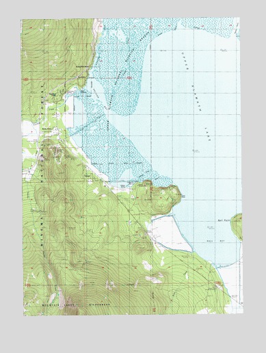
Pelican Bay, OR USGS Topographic Map
Click on map above to begin viewing in our Map Viewer.

This topographic map contains these locations and features:
Feature Name Type Latitude Longitude GNIS ID View Map
Ball BayBayN42.4096°W122.0204°1161258View Map
Ball PointCapeN42.4146°W122.0056°1161259View Map
Bud SpringSpringN42.4282°W122.0517°1162792View Map
Camporee SpringSpringN42.4304°W122.0618°1139293View Map
Coon PointCapeN42.4265°W122.0367°1161323View Map
Crystal CreekStreamN42.4626°W122.0753°1161336View Map
Denny Creek Historic MonumentParkN42.3854°W122.0153°1163699View Map
Doaks MarshSwampN42.3771°W122.0080°1154955View Map
Fourmile CreekStreamN42.4701°W122.0900°1142368View Map
Harriman LodgeLocaleN42.4671°W122.1014°1143324View Map
Harriman Rural Fire DepartmentBuildingN42.4557°W122.1067°1156243View Map
Harriman SpringSpringN42.4683°W122.1002°1154946View Map
Keno DivisionCivilN42.3880°W122.1059°1938040View Map
Klamath County DumpLocaleN42.4137°W122.0650°1167661View Map
Long Rifle Cinder PitMineN42.4082°W122.0595°1135155View Map
Moss CreekStreamN42.3982°W122.0333°1161447View Map
Mountain Lakes Organizational CampLocaleN42.4193°W122.1200°1135154View Map
Odessa Campground Boat LaunchLocaleN42.4309°W122.0604°2700254View Map
Odessa Cinder PitMineN42.4090°W122.0561°1135156View Map
Odessa CreekStreamN42.4360°W122.0511°1161462View Map
Odessa Post Office (historical)Post OfficeN42.4374°W122.0872°1165733View Map
Odessa Recreation SiteLocaleN42.4296°W122.0606°1135157View Map
Odessa SpringSpringN42.4285°W122.0671°1154944View Map
Pelican BayBayN42.4688°W122.0829°1147567View Map
Pelican Cinder PitMineN42.4415°W122.1150°1135153View Map
Pelican Cut CanalCanalN42.4568°W122.0859°1135152View Map
Pelican Fire Guard StationLocaleN42.4546°W122.1067°1156244View Map
Pelican Guard StationLocaleN42.4479°W122.1156°1147571View Map
Point ComfortCapeN42.4726°W122.0889°1147818View Map
Recreation (historical)Populated PlaceN42.4743°W122.0889°1135151View Map
Recreation CreekStreamN42.4760°W122.0856°1148270View Map
Recreation Post Office (historical)Post OfficeN42.4743°W122.0889°1165837View Map
Rocky PointPopulated PlaceN42.4807°W122.0842°1161493View Map
Rocky Point Fire and Emergency Medical ServicesBuildingN42.4596°W122.1063°2577152View Map
Rocky Point Post Office (historical)Post OfficeN42.4807°W122.0842°1165875View Map
Rocky Point Recreation SiteLocaleN42.4785°W122.0867°1926283View Map
Rocky Point Resort Boat LaunchLocaleN42.4777°W122.0871°2700253View Map
Short CreekStreamN42.4340°W122.0470°1161509View Map
Thomason CreekStreamN42.4954°W122.0350°1151082View Map
Tomahawk Ski Bowl (historical)LocaleN42.4471°W122.1067°1154945View Map
Varney CreekStreamN42.4529°W122.0978°1161571View Map
Varney Creek TrailTrailN42.3810°W122.1095°1156242View Map
Wampler MarshSwampN42.4150°W122.0394°1154954View Map
Wampler SpringSpringN42.4096°W122.0553°1154963View Map

Note: Coordinates in the location and feature list above are referenced to NAD83 datum.


Copyright (C) 2008-2024 Ryan Niemi / Sunset Dynamics ... All Rights Reserved