TopoQuest Logo
Do you find TopoQuest useful?
Help keep TopoQuest running and adding new maps/features by donating!
Bitcoin:  19c7KJd3qBynnjoSw5npx9KScwjBe4ifkT
Litecoin:  LXs6TkuXGGXo1vDsWCkWVdjQX94eUKd6ui
Home View Maps Find Maps Find Places Resources & Links


Parshall, Colorado Topographic Map

USGS Map Title: Parshall, CO
USGS Map MRC: 40106A2
DRG (GeoTIFF) Download: o40106a2.tif


Neighboring USGS Topographic Map Quads:


  Gunsight Pass, CO  
40106B3
 

  Corral Peaks, CO  
40106B2
 

  Cabin Creek, CO  
40106B1
 

  Junction Butte, CO  
40106A3
 

  Parshall, CO  
40106A2
 

  Hot Sulphur Springs, CO  
40106A1
 

  King Creek, CO  
39106H3
 

  Battle Mountain, CO  
39106H2
 

  Sylvan Reservoir, CO  
39106H1


Map MRC Location:

N41°
W107°
N41°
W106°
H8 H7 H6 H5 H4 H3 H2 H1
G8 G7 G6 G5 G4 G3 G2 G1
F8 F7 F6 F5 F4 F3 F2 F1
E8 E7 E6 E5 E4 E3 E2 E1
D8 D7 D6 D5 D4 D3 D2 D1
C8 C7 C6 C5 C4 C3 C2 C1
B8 B7 B6 B5 B4 B3 B2 B1
A8 A7 A6 A5 A4 A3 A2 A1
N40°
W107°
N40°
W106°

Parshall, CO USGS 1:24K Topographic Map Preview:
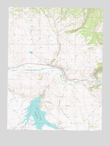
Parshall, CO USGS Topographic Map
Click on map above to begin viewing in our Map Viewer.

This topographic map contains these locations and features:
Feature Name Type Latitude Longitude GNIS ID View Map
Battle CreekStreamN40.0264°W106.2111°173242View Map
Beaver CreekStreamN40.0478°W106.1314°173246View Map
Big Lake DitchCanalN40.0019°W106.2256°202137View Map
Byers CanyonValleyN40.0527°W106.1333°173284View Map
Colorado State Rifle RangeLocaleN40.0519°W106.1472°1947631View Map
Copper CreekStreamN40.0025°W106.2059°175634View Map
Corral CreekStreamN40.0633°W106.1914°173233View Map
Dry GulchValleyN40.0863°W106.2166°173272View Map
First CreekStreamN40.1061°W106.1889°173274View Map
FlatLocaleN40.0680°W106.2172°173250View Map
Gilbert CampgroundLocaleN40.0511°W106.1306°197552View Map
Jensen CreekStreamN40.0633°W106.1872°173235View Map
Johnson GulchValleyN40.0045°W106.2268°173281View Map
Kinney CreekStreamN40.0119°W106.2186°173241View Map
Kitchen CreekStreamN40.0272°W106.1256°173283View Map
Little Muddy CreekStreamN40.0461°W106.1453°173245View Map
McQueary GulchValleyN40.0072°W106.2325°196646View Map
Mount BrossSummitN40.0922°W106.1334°1947632View Map
Musgrave DamDamN40.1183°W106.2006°201562View Map
Musgrave DitchCanalN40.1125°W106.2089°173258View Map
Musgrave ReservoirReservoirN40.1183°W106.2006°201563View Map
ParshallPopulated PlaceN40.0569°W106.1753°173266View Map
Parshall Census Designated PlaceCensusN40.0556°W106.1760°2583276View Map
Parshall Post OfficePost OfficeN40.0567°W106.1768°2734618View Map
Rock CreekStreamN40.0630°W106.2295°173234View Map
Rock Creek DamDamN40.0783°W106.2189°201472View Map
Rock Creek ReservoirReservoirN40.0790°W106.2200°201473View Map
Second CreekStreamN40.1119°W106.1903°173273View Map
Smith CreekStreamN40.0986°W106.1859°173277View Map
Williams ForkStreamN40.0564°W106.1800°173243View Map
Williams Fork DamDamN40.0353°W106.2050°199472View Map
Williams Fork ReservoirReservoirN40.0145°W106.2099°173267View Map

Note: Coordinates in the location and feature list above are referenced to NAD83 datum.


Copyright (C) 2008-2024 Ryan Niemi / Sunset Dynamics ... All Rights Reserved