TopoQuest Logo
Do you find TopoQuest useful?
Help keep TopoQuest running and adding new maps/features by donating!
Bitcoin:  19c7KJd3qBynnjoSw5npx9KScwjBe4ifkT
Litecoin:  LXs6TkuXGGXo1vDsWCkWVdjQX94eUKd6ui
Home View Maps Find Maps Find Places Resources & Links


Panguitch Lake, Utah Topographic Map

USGS Map Title: Panguitch Lake, UT
USGS Map MRC: 37112F6
DRG (GeoTIFF) Download: o37112f6.tif


Neighboring USGS Topographic Map Quads:


  Parowan, UT  
37112G7
 

  Red Creek Reservoir, UT  
37112G6
 

  Fivemile Ridge, UT  
37112G5
 

  Brian Head, UT  
37112F7
 

  Panguitch Lake, UT  
37112F6
 

  Haycock Mountain, UT  
37112F5
 

  Navajo Lake, UT  
37112E7
 

  Henrie Knolls, UT  
37112E6
 

  Asay Bench, UT  
37112E5


Map MRC Location:

N38°
W113°
N38°
W112°
H8 H7 H6 H5 H4 H3 H2 H1
G8 G7 G6 G5 G4 G3 G2 G1
F8 F7 F6 F5 F4 F3 F2 F1
E8 E7 E6 E5 E4 E3 E2 E1
D8 D7 D6 D5 D4 D3 D2 D1
C8 C7 C6 C5 C4 C3 C2 C1
B8 B7 B6 B5 B4 B3 B2 B1
A8 A7 A6 A5 A4 A3 A2 A1
N37°
W113°
N37°
W112°

Panguitch Lake, UT USGS 1:24K Topographic Map Preview:
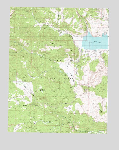
Panguitch Lake, UT USGS Topographic Map
Click on map above to begin viewing in our Map Viewer.

This topographic map contains these locations and features:
Feature Name Type Latitude Longitude GNIS ID View Map
Beaver Dam LodgeLocaleN37.7283°W112.6524°1451185View Map
Big SpringSpringN37.6283°W112.6924°1438732View Map
Birch SpringsSpringN37.6544°W112.6791°1435147View Map
Blue SpringSpringN37.6828°W112.6771°1438953View Map
Blue Spring CreekStreamN37.7066°W112.6588°1438956View Map
Blue Spring CreekStreamN37.7055°W112.6591°1449917View Map
Blue Spring MountainSummitN37.6703°W112.7027°1438959View Map
Blue Spring ValleyBasinN37.6853°W112.6744°1438960View Map
Bunker CreekStreamN37.6936°W112.6752°1439327View Map
Cameron TroughsSpringN37.6690°W112.6287°1448221View Map
Castle CreekStreamN37.6525°W112.7163°1439512View Map
Castle ValleyValleyN37.6544°W112.7174°1439520View Map
Clear CreekStreamN37.7153°W112.6602°1439789View Map
Dead LakeLakeN37.6356°W112.6990°1440302View Map
Deer CreekStreamN37.6930°W112.6827°1440364View Map
Deer Trail LogdeLocaleN37.7264°W112.6869°1451227View Map
Dry ValleyBasinN37.6497°W112.6735°1440685View Map
John L FlatFlatN37.6372°W112.7085°1455881View Map
Left Fork Bunker CreekStreamN37.7078°W112.7294°1448583View Map
Mammoth Creek Volunteer Fire DepartmentBuildingN37.6254°W112.6404°2627414View Map
Mammoth SpringSpringN37.6354°W112.6712°1443118View Map
Mammoth Springs CampgroundLocaleN37.6378°W112.6716°1451290View Map
Miller KnollSummitN37.6689°W112.6533°1443489View Map
Panguitch LakeReservoirN37.7159°W112.6414°1447643View Map
Panguitch Lake DamDamN37.7247°W112.6279°1447644View Map
Panguitch Lake North CampgroundLocaleN37.7022°W112.6560°1451319View Map
Panguitch Lake ResortPopulated PlaceN37.7080°W112.6416°1451320View Map
Panguitch Lake South CampgroundLocaleN37.7005°W112.6558°1451321View Map
Panquitch Lake Forest Service StationLocaleN37.7047°W112.6505°1455692View Map
Prince MountainSummitN37.7128°W112.6913°1444648View Map
Right Fork Bunker CreekStreamN37.7078°W112.7294°1448918View Map
Rustic LodgeLocaleN37.7214°W112.6663°1451346View Map
Skoots CreekStreamN37.7239°W112.6769°1445635View Map
Taylor SpringSpringN37.6700°W112.6696°1446356View Map
Tommy CreekStreamN37.6264°W112.6460°1446640View Map
Twin HollowValleyN37.7472°W112.6374°1446784View Map
Yellowjacket SpringSpringN37.6547°W112.6789°1447562View Map

Note: Coordinates in the location and feature list above are referenced to NAD83 datum.


Copyright (C) 2008-2024 Ryan Niemi / Sunset Dynamics ... All Rights Reserved