TopoQuest Logo
Do you find TopoQuest useful?
Help keep TopoQuest running and adding new maps/features by donating!
Bitcoin:  19c7KJd3qBynnjoSw5npx9KScwjBe4ifkT
Litecoin:  LXs6TkuXGGXo1vDsWCkWVdjQX94eUKd6ui
Home View Maps Find Maps Find Places Resources & Links


Paducah West, Kentucky Topographic Map

USGS Map Title: Paducah West, KY
USGS Map MRC: 37088A6
DRG (GeoTIFF) Download: o37088a6.tif


Neighboring USGS Topographic Map Quads:


  Joppa, IL  
37088B7
 

  Metropolis, IL  
37088B6
 

  Paducah NE, IL  
37088B5
 

  Heath, KY  
37088A7
 

  Paducah West, KY  
37088A6
 

  Paducah East, KY  
37088A5
 

  Lovelaceville, KY  
36088H7
 

  Melber, KY  
36088H6
 

  Symsonia, KY  
36088H5


Map MRC Location:

N38°
W89°
N38°
W88°
H8 H7 H6 H5 H4 H3 H2 H1
G8 G7 G6 G5 G4 G3 G2 G1
F8 F7 F6 F5 F4 F3 F2 F1
E8 E7 E6 E5 E4 E3 E2 E1
D8 D7 D6 D5 D4 D3 D2 D1
C8 C7 C6 C5 C4 C3 C2 C1
B8 B7 B6 B5 B4 B3 B2 B1
A8 A7 A6 A5 A4 A3 A2 A1
N37°
W89°
N37°
W88°

Paducah West, KY USGS 1:24K Topographic Map Preview:
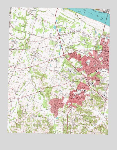
Paducah West, KY USGS Topographic Map
Click on map above to begin viewing in our Map Viewer.

This topographic map contains these locations and features:
Feature Name Type Latitude Longitude GNIS ID View Map
Andrew Jackson SchoolSchoolN37.0826°W88.6262°485946View Map
Avondale HeightsPopulated PlaceN37.0723°W88.6500°486160View Map
Baptist Health Paducah HospitalHospitalN37.0742°W88.6272°2660358View Map
Bellview ChurchChurchN37.0328°W88.6289°486828View Map
Beyer CemeteryCemeteryN37.0255°W88.6670°487068View Map
Black BranchStreamN37.0817°W88.7298°487356View Map
Brazelton SchoolSchoolN37.0662°W88.6381°487849View Map
BrookportPopulated PlaceN37.1237°W88.6303°424673View Map
Brookport Elemenatary SchoolSchoolN37.1245°W88.6300°1821506View Map
Brookport Fire DepartmentBuildingN37.1232°W88.6282°2640162View Map
Brookport Police DepartmentBuildingN37.1235°W88.6281°2759075View Map
Brookport Post OfficePost OfficeN37.1230°W88.6278°2788449View Map
Brookport United Methodist ChurchChurchN37.1242°W88.6325°1821507View Map
Brooks Memorial ParkCemeteryN37.0458°W88.6676°2775635View Map
Bumpous CemeteryCemeteryN37.0384°W88.7404°488383View Map
Carson ParkParkN37.0745°W88.6345°488988View Map
CecilPopulated PlaceN37.1026°W88.6670°489155View Map
ChilesPopulated PlaceN37.1137°W88.7492°507697View Map
Church of ChristChurchN37.1234°W88.6306°1821510View Map
Church of GodChurchN37.1245°W88.6270°1821511View Map
City of Lone Oak (historical)CivilN37.0363°W88.6655°2404951View Map
City of PaducahCivilN37.0711°W88.6435°2404458View Map
Clark SchoolSchoolN37.0689°W88.6420°489546View Map
ConcordPopulated PlaceN37.0723°W88.7001°1867277View Map
Concord Fire Department Station 1BuildingN37.0711°W88.7006°2636800View Map
Concord Fire Department Station 3BuildingN37.0917°W88.7107°2637340View Map
Concord SchoolSchoolN37.0728°W88.6942°489944View Map
Crooked CreekStreamN37.0709°W88.6787°490375View Map
Dam Number 52DamN37.1231°W88.6553°424815View Map
Dam Number 52DamN37.1215°W88.6563°517130View Map
Forest HillPopulated PlaceN37.0534°W88.6384°492321View Map
FutrellPopulated PlaceN37.0917°W88.6895°508055View Map
HendronPopulated PlaceN37.0395°W88.6292°494048View Map
Hendron Census Designated PlaceCensusN37.0346°W88.6437°2402577View Map
Hendron Fire DepartmentBuildingN37.0389°W88.6302°2636385View Map
High PointPopulated PlaceN37.1142°W88.7156°494186View Map
Highland CemeteryCemeteryN37.0287°W88.6926°494200View Map
Highland ChurchChurchN37.0301°W88.6839°494205View Map
Highland Church (historical)Populated PlaceN37.0306°W88.6847°2743775View Map
HinklevillePopulated PlaceN37.0838°W88.6465°2743776View Map
Irvin S Cobb BridgeBridgeN37.1151°W88.6289°495022View Map
Irvin S Cobb BridgeBridgeN37.1153°W88.6289°425036View Map
Jacobs LakeLakeN37.1042°W88.6387°495139View Map
Keiler ParkParkN37.0712°W88.6345°495605View Map
Langs (historical)Populated PlaceN37.0523°W88.6750°2743782View Map
Lebanon ChurchChurchN37.0381°W88.6292°496134View Map
Little Union Community CenterBuildingN37.0598°W88.7456°496888View Map
Lone OakPopulated PlaceN37.0362°W88.6648°496999View Map
Lone Oak Fire Department Station 1BuildingN37.0313°W88.6715°2636468View Map
Lone Oak Fire Department Station 2BuildingN37.0157°W88.7306°2637178View Map
Lone Oak ParkParkN37.0398°W88.6751°497001View Map
Long HoleLakeN37.1012°W88.7301°497115View Map
Lourdes HospitalHospitalN37.0506°W88.6472°2660395View Map
Lourdes Hospital HeliportAirportN37.0603°W88.6484°517464View Map
Maplelawn CemeteryCemeteryN37.0895°W88.6253°497521View Map
MassacPopulated PlaceN37.0167°W88.7306°508556View Map
Massac CemeteryCemeteryN37.0193°W88.7271°497669View Map
Massac Census Designated PlaceCensusN37.0335°W88.6859°2403262View Map
Massac County Fire Protection District Station 2BuildingN37.1236°W88.6286°2640566View Map
MaxonPopulated PlaceN37.0889°W88.7306°508566View Map
Maxon ChurchChurchN37.0795°W88.7459°497696View Map
Maxon StationLocaleN37.0845°W88.7459°497697View Map
McCracken CountyCivilN37.0541°W88.7127°516925View Map
McCracken Regional Juvenile Detention CenterBuildingN37.0898°W88.6717°2767779View Map
McCracken Regional Juvenile Detention Center Alternative SchoolSchoolN37.0898°W88.6717°2767710View Map
Mercy Regional Emergency Medical ServicesBuildingN37.0891°W88.6770°2719090View Map
Middle Fork Massac CreekStreamN37.0545°W88.7214°498130View Map
Mount Carmel CemeteryCemeteryN37.0466°W88.6285°498695View Map
Mount Kenton CemeteryCemeteryN37.0435°W88.6595°498761View Map
Noble ParkParkN37.0864°W88.6381°499496View Map
Ohio River PoolReservoirN37.1223°W88.6553°499779View Map
Olivia ChurchChurchN37.0978°W88.6864°499936View Map
Paducah DivisionCivilN37.0580°W88.6322°1937186View Map
Paducah Fire Department Station 3BuildingN37.0792°W88.6740°2636747View Map
Paducah Fire Department Station 4BuildingN37.0651°W88.6368°2636576View Map
Palestine (historical)Populated PlaceN37.0987°W88.7475°2743789View Map
Palestine ChurchChurchN37.0987°W88.7484°500135View Map
Park Avenue ChurchChurchN37.0831°W88.6489°500177View Map
Paxton ParkParkN37.0614°W88.6309°500287View Map
Perkins CreekStreamN37.1212°W88.6656°500416View Map
Pleasant Grove (historical)Populated PlaceN37.0557°W88.6789°2743791View Map
Pleasant Grove CemeteryCemeteryN37.0570°W88.6784°2775636View Map
Pleasant Grove ChurchChurchN37.0562°W88.6781°500818View Map
Rolling Hills Country ClubLocaleN37.0346°W88.6466°517273View Map
RowlandtownPopulated PlaceN37.0917°W88.6334°502433View Map
Saint Matthews CemeteryCemeteryN37.0091°W88.6656°502697View Map
Spring HillPopulated PlaceN37.0463°W88.7031°2743794View Map
Stanley CemeteryCemeteryN37.0848°W88.6977°504259View Map
Stewart Nelson ParkParkN37.0926°W88.6562°504385View Map
Superior Care HomeBuildingN37.0761°W88.6394°2573612View Map
Temple Israel CemeteryCemeteryN37.0420°W88.6598°2755401View Map
West Fork Massac CreekStreamN37.0934°W88.7312°506438View Map
West Kentucky SchoolSchoolN37.0903°W88.6317°506459View Map
West PaducahPopulated PlaceN37.0831°W88.7442°506464View Map
West Paducah SchoolSchoolN37.0887°W88.7356°506466View Map
Western Baptist Hospital HeliportAirportN37.0751°W88.6256°517462View Map
White Oak CemeteryCemeteryN37.0878°W88.6744°2775637View Map
White Oak ChurchChurchN37.1003°W88.6734°506604View Map
WKPD-TV (Paducah)TowerN37.0939°W88.6720°518067View Map

Note: Coordinates in the location and feature list above are referenced to NAD83 datum.


Copyright (C) 2008-2024 Ryan Niemi / Sunset Dynamics ... All Rights Reserved