TopoQuest Logo
Do you find TopoQuest useful?
Help keep TopoQuest running and adding new maps/features by donating!
Bitcoin:  19c7KJd3qBynnjoSw5npx9KScwjBe4ifkT
Litecoin:  LXs6TkuXGGXo1vDsWCkWVdjQX94eUKd6ui
Home View Maps Find Maps Find Places Resources & Links


Orange, Virginia Topographic Map

USGS Map Title: Orange, VA
USGS Map MRC: 38078B1
DRG (GeoTIFF) Download: o38078b1.tif


Neighboring USGS Topographic Map Quads:


  Madison Mills, VA  
38078C2
 

  Rapidan, VA  
38078C1
 

  Unionville, VA  
38077C8
 

  Gordonsville, VA  
38078B2
 

  Orange, VA  
38078B1
 

  Lahore, VA  
38077B8
 

  Boswells Tavern, VA  
38078A2
 

  Louisa, VA  
38078A1
 

  Mineral, VA  
38077A8


Map MRC Location:

N39°
W79°
N39°
W78°
H8 H7 H6 H5 H4 H3 H2 H1
G8 G7 G6 G5 G4 G3 G2 G1
F8 F7 F6 F5 F4 F3 F2 F1
E8 E7 E6 E5 E4 E3 E2 E1
D8 D7 D6 D5 D4 D3 D2 D1
C8 C7 C6 C5 C4 C3 C2 C1
B8 B7 B6 B5 B4 B3 B2 B1
A8 A7 A6 A5 A4 A3 A2 A1
N38°
W79°
N38°
W78°

Orange, VA USGS 1:24K Topographic Map Preview:
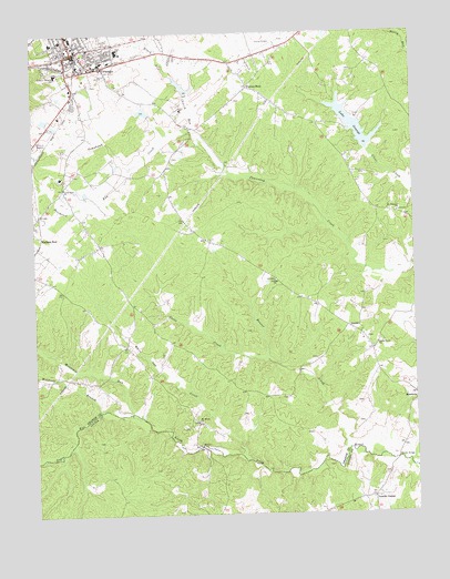
Orange, VA USGS Topographic Map
Click on map above to begin viewing in our Map Viewer.

This topographic map contains these locations and features:
Feature Name Type Latitude Longitude GNIS ID View Map
Beaver CreekStreamN38.1415°W78.0225°1462928View Map
Black RunStreamN38.2393°W78.0778°1463506View Map
Brocks BridgeBridgeN38.1390°W78.0064°1463867View Map
Calvary ChurchChurchN38.1860°W78.0456°1464289View Map
Church RunStreamN38.2246°W78.0703°1464918View Map
Clear Creek DamDamN38.2201°W78.0131°1490521View Map
Cooks CreekStreamN38.1654°W78.0489°1465197View Map
DanielPopulated PlaceN38.1737°W78.0219°1496867View Map
District 2CivilN38.1896°W78.0586°1927209View Map
J E Taylor DamDamN38.2285°W78.0881°1490526View Map
J E Taylor LakeReservoirN38.2298°W78.0881°1490527View Map
Lake OrangeReservoirN38.2262°W78.0189°1471939View Map
Lewis CemeteryCemeteryN38.2401°W78.0192°1494749View Map
Little Zion ChurchChurchN38.2101°W78.1144°1469700View Map
Mallory FordLocaleN38.1426°W78.0711°1470028View Map
Mount Horeb CemeteryCemeteryN38.1493°W78.0717°1494753View Map
Mount Horeb ChurchChurchN38.1490°W78.0717°1470912View Map
Mount Pleasant ChurchChurchN38.2032°W78.0050°1471044View Map
Mountain RunStreamN38.1515°W78.0928°1471177View Map
Negro RunStreamN38.1518°W78.0928°1471372View Map
OrangePopulated PlaceN38.2454°W78.1108°1498525View Map
Orange CountyCivilN38.2462°W78.0137°1494761View Map
Orange County AirportAirportN38.2480°W78.0488°1498768View Map
Orange County CourthouseBuildingN38.2454°W78.1108°1494762View Map
Orange County Emergency ServicesBuildingN38.2447°W78.1116°2331792View Map
Orange County High SchoolSchoolN38.2452°W78.0961°1494763View Map
Orange County Rescue SquadBuildingN38.2409°W78.1072°2331759View Map
Orange County Rescue Squad Station 23BuildingN38.2414°W78.1071°2075259View Map
Orange County Sheriff's OfficeBuildingN38.2468°W78.0360°2331931View Map
Orange Elementary SchoolSchoolN38.2478°W78.1183°1494764View Map
Orange Police DepartmentBuildingN38.2440°W78.1108°2331962View Map
Orange Post OfficePost OfficeN38.2449°W78.1125°1496484View Map
Orange Seventh Day Adventist ChurchChurchN38.2479°W78.1158°1496485View Map
Orange Volunteer Fire CompanyBuildingN38.2409°W78.1127°2075306View Map
Pierces ShopLocaleN38.2360°W78.0533°1472285View Map
Poorhouse RunStreamN38.2154°W78.0928°1472619View Map
Prospect Heights Middle SchoolSchoolN38.2392°W78.1202°1472810View Map
Saint Thomas Episcopal ChurchChurchN38.2437°W78.1133°1494772View Map
Shady Grove CemeteryCemeteryN38.1682°W78.0135°1494774View Map
Shady Grove ChurchChurchN38.1687°W78.0122°1474203View Map
Taylors DamDamN38.2335°W78.0731°1490522View Map
Taylors PondReservoirN38.2362°W78.0749°1490523View Map
Tomahawk CreekStreamN38.2246°W78.0703°1475766View Map
Town of OrangeCivilN38.2485°W78.1125°2391347View Map
Vawter CornerPopulated PlaceN38.1290°W78.0142°1497188View Map
Watkins CemeteryCemeteryN38.1654°W78.0325°1494783View Map
White Oak CreekStreamN38.1390°W78.0547°1476603View Map
Willis CemeteryCemeteryN38.1554°W78.0347°1494787View Map
Wolftrap BranchStreamN38.1521°W78.1028°1476920View Map

Note: Coordinates in the location and feature list above are referenced to NAD83 datum.


Copyright (C) 2008-2024 Ryan Niemi / Sunset Dynamics ... All Rights Reserved