TopoQuest Logo
Do you find TopoQuest useful?
Help keep TopoQuest running and adding new maps/features by donating!
Bitcoin:  19c7KJd3qBynnjoSw5npx9KScwjBe4ifkT
Litecoin:  LXs6TkuXGGXo1vDsWCkWVdjQX94eUKd6ui
Home View Maps Find Maps Find Places Resources & Links


Oneida, Illinois Topographic Map

USGS Map Title: Oneida, IL
USGS Map MRC: 41090A2
DRG (GeoTIFF) Download: o41090a2.tif


Neighboring USGS Topographic Map Quads:


  Woodhull, IL  
41090B3
 

  Nekoma, IL  
41090B2
 

  Galva, IL  
41090B1
 

  Wataga, IL  
41090A3
 

  Oneida, IL  
41090A2
 

  Victoria, IL  
41090A1
 

  Galesburg East, IL  
40090H3
 

  Appleton, IL  
40090H2
 

  Williamsfield, IL  
40090H1


Map MRC Location:

N42°
W91°
N42°
W90°
H8 H7 H6 H5 H4 H3 H2 H1
G8 G7 G6 G5 G4 G3 G2 G1
F8 F7 F6 F5 F4 F3 F2 F1
E8 E7 E6 E5 E4 E3 E2 E1
D8 D7 D6 D5 D4 D3 D2 D1
C8 C7 C6 C5 C4 C3 C2 C1
B8 B7 B6 B5 B4 B3 B2 B1
A8 A7 A6 A5 A4 A3 A2 A1
N41°
W91°
N41°
W90°

Oneida, IL USGS 1:24K Topographic Map Preview:
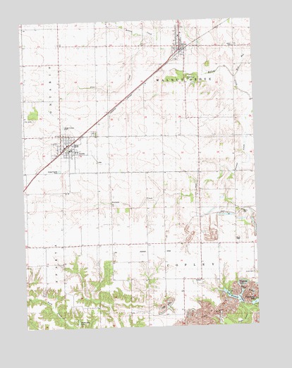
Oneida, IL USGS Topographic Map
Click on map above to begin viewing in our Map Viewer.

This topographic map contains these locations and features:
Feature Name Type Latitude Longitude GNIS ID View Map
AltonaPopulated PlaceN41.1148°W90.1646°403472View Map
Altona - Oneida - Wataga Ambulance ServiceBuildingN41.0733°W90.2292°2640452View Map
Altona - Oneida - Wataga Ambulance ServiceBuildingN41.1137°W90.1625°2673918View Map
Altona CemeteryCemeteryN41.1092°W90.1662°1815927View Map
Altona Elementary SchoolSchoolN41.1186°W90.1635°1815928View Map
Altona Fire Protection DistrictBuildingN41.1138°W90.1621°2640549View Map
Altona Post OfficePost OfficeN41.1139°W90.1643°2788201View Map
Austin School (historical)SchoolN41.1145°W90.1362°403744View Map
City of OneidaCivilN41.0722°W90.2247°2396067View Map
Cummings School (historical)SchoolN41.0775°W90.1557°406889View Map
Ferris School (historical)SchoolN41.0778°W90.1943°408344View Map
Finley School (historical)SchoolN41.1086°W90.2290°408377View Map
Fishhook LakeReservoirN41.0184°W90.1334°1719892View Map
Fosmire School (historical)SchoolN41.0345°W90.2296°408561View Map
Hannam School (historical)SchoolN41.0564°W90.2479°409749View Map
Hobbs School (historical)SchoolN41.0345°W90.2035°410330View Map
Knox County LandfillLocaleN41.0164°W90.2478°2680875View Map
Lake WindsorReservoirN41.0100°W90.1335°1691475View Map
Lake Windsor DamDamN41.0100°W90.1335°1691474View Map
Larson CemeteryCemeteryN41.1144°W90.1359°1719889View Map
Martin CemeteryCemeteryN41.0464°W90.1321°1719888View Map
McKie School (historical)SchoolN41.0486°W90.1701°413295View Map
Mud RunStreamN41.1020°W90.1351°414195View Map
Old Scotch CemeteryCemeteryN41.0214°W90.1276°1719890View Map
OneidaPopulated PlaceN41.0723°W90.2254°415123View Map
Oneida - Wataga Fire Protection DistrictBuildingN41.0720°W90.2254°2640317View Map
Oneida - Wataga Fire Protection DistrictBuildingN41.0733°W90.2287°2640837View Map
Oneida CemeteryCemeteryN41.0795°W90.2117°415124View Map
Oneida Elementary SchoolSchoolN41.0745°W90.2210°1815988View Map
Oneida Post OfficePost OfficeN41.0733°W90.2239°2788251View Map
Pilot CreekStreamN41.1186°W90.1823°1719882View Map
Pilot GroveWoodsN41.0875°W90.2435°1815991View Map
Pilot KnobSummitN41.0850°W90.2471°415684View Map
Rhodes School (historical)SchoolN41.0098°W90.2496°416576View Map
Roundhouse LakeReservoirN41.0101°W90.1254°1691477View Map
Roundhouse Lake DamDamN41.0084°W90.1285°1691476View Map
Shebb Oaks LakeReservoirN41.0023°W90.2220°1691511View Map
Shebb Oaks Lake DamDamN41.0017°W90.2235°1691510View Map
Township of CopleyCivilN41.0192°W90.1544°428842View Map
Township of Walnut GroveCivilN41.1069°W90.1532°429888View Map
Village of AltonaCivilN41.1151°W90.1648°2397949View Map
Walnut Grove CemeteryCemeteryN41.1022°W90.1593°420454View Map
Windmill School (historical)SchoolN41.0192°W90.1687°421316View Map

Note: Coordinates in the location and feature list above are referenced to NAD83 datum.


Copyright (C) 2008-2024 Ryan Niemi / Sunset Dynamics ... All Rights Reserved