TopoQuest Logo
Do you find TopoQuest useful?
Help keep TopoQuest running and adding new maps/features by donating!
Bitcoin:  19c7KJd3qBynnjoSw5npx9KScwjBe4ifkT
Litecoin:  LXs6TkuXGGXo1vDsWCkWVdjQX94eUKd6ui
Home View Maps Find Maps Find Places Resources & Links


Ogletown, Pennsylvania Topographic Map

USGS Map Title: Ogletown, PA
USGS Map MRC: 40078B6
DRG (GeoTIFF) Download: o40078b6.tif


Neighboring USGS Topographic Map Quads:


  Geistown, PA  
40078C7
 

  Beaverdale, PA  
40078C6
 

  Blue Knob, PA  
40078C5
 

  Windber, PA  
40078B7
 

  Ogletown, PA  
40078B6
 

  Alum Bank, PA  
40078B5
 

  Central City, PA  
40078A7
 

  Schellsburg, PA  
40078A6
 

  Bedford, PA  
40078A5


Map MRC Location:

N41°
W79°
N41°
W78°
H8 H7 H6 H5 H4 H3 H2 H1
G8 G7 G6 G5 G4 G3 G2 G1
F8 F7 F6 F5 F4 F3 F2 F1
E8 E7 E6 E5 E4 E3 E2 E1
D8 D7 D6 D5 D4 D3 D2 D1
C8 C7 C6 C5 C4 C3 C2 C1
B8 B7 B6 B5 B4 B3 B2 B1
A8 A7 A6 A5 A4 A3 A2 A1
N40°
W79°
N40°
W78°

Ogletown, PA USGS 1:24K Topographic Map Preview:
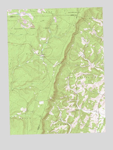
Ogletown, PA USGS Topographic Map
Click on map above to begin viewing in our Map Viewer.

This topographic map contains these locations and features:
Feature Name Type Latitude Longitude GNIS ID View Map
Babcock State ForestForestN40.2306°W78.7150°1168548View Map
Callihan CreekStreamN40.1561°W78.6597°2084376View Map
Calvary ChurchChurchN40.2112°W78.6456°1170929View Map
Calvary HollowValleyN40.1930°W78.6409°1170947View Map
CrumbPopulated PlaceN40.1484°W78.7267°1203376View Map
Cub RunStreamN40.1715°W78.7459°1172808View Map
Dunning Creek ChurchChurchN40.1648°W78.6609°1173625View Map
Felix Post Office (historical)Post OfficeN40.2034°W78.7031°1214324View Map
Galion Bay DamDamN40.1584°W78.7181°1194593View Map
Gallitzin State ForestForestN40.2084°W78.7081°1209219View Map
Gordon CreekStreamN40.1929°W78.6400°1175837View Map
Lake ReneReservoirN40.1701°W78.7114°1194600View Map
Lake Rene DamDamN40.1701°W78.7114°1194601View Map
Lake Sabula DamDamN40.1534°W78.6664°1194590View Map
Mock Church CemeteryCemeteryN40.1665°W78.6401°2776113View Map
OgletownPopulated PlaceN40.2026°W78.7031°1182874View Map
Pine LakeReservoirN40.2162°W78.6982°1183857View Map
Pot RidgeRidgeN40.2367°W78.7100°1184322View Map
Rocklick SchoolSchoolN40.1381°W78.6828°1206839View Map
RyotPopulated PlaceN40.1459°W78.6367°1185671View Map
Ryot RunStreamN40.1398°W78.6259°1202516View Map
Township of OgleCivilN40.1976°W78.7363°1217058View Map
Township of West Saint ClairCivilN40.1756°W78.6370°1215910View Map
Wolf Creek DamDamN40.1784°W78.7397°1194604View Map

Note: Coordinates in the location and feature list above are referenced to NAD83 datum.


Copyright (C) 2008-2024 Ryan Niemi / Sunset Dynamics ... All Rights Reserved