TopoQuest Logo
Do you find TopoQuest useful?
Help keep TopoQuest running and adding new maps/features by donating!
Bitcoin:  19c7KJd3qBynnjoSw5npx9KScwjBe4ifkT
Litecoin:  LXs6TkuXGGXo1vDsWCkWVdjQX94eUKd6ui
Home View Maps Find Maps Find Places Resources & Links


Oakwood, Illinois Topographic Map

USGS Map Title: Oakwood, IL
USGS Map MRC: 40087A7
DRG (GeoTIFF) Download: o40087a7.tif


Neighboring USGS Topographic Map Quads:


  Royal, IL  
40087B8
 

  Collison, IL  
40087B7
 

  Danville NW, IL  
40087B6
 

  Homer, IL  
40087A8
 

  Oakwood, IL  
40087A7
 

  Danville SW, IL  
40087A6
 

  Allerton, IL  
39087H8
 

  Sidell, IL  
39087H7
 

  Georgetown, IL  
39087H6


Map MRC Location:

N41°
W88°
N41°
W87°
H8 H7 H6 H5 H4 H3 H2 H1
G8 G7 G6 G5 G4 G3 G2 G1
F8 F7 F6 F5 F4 F3 F2 F1
E8 E7 E6 E5 E4 E3 E2 E1
D8 D7 D6 D5 D4 D3 D2 D1
C8 C7 C6 C5 C4 C3 C2 C1
B8 B7 B6 B5 B4 B3 B2 B1
A8 A7 A6 A5 A4 A3 A2 A1
N40°
W88°
N40°
W87°

Oakwood, IL USGS 1:24K Topographic Map Preview:
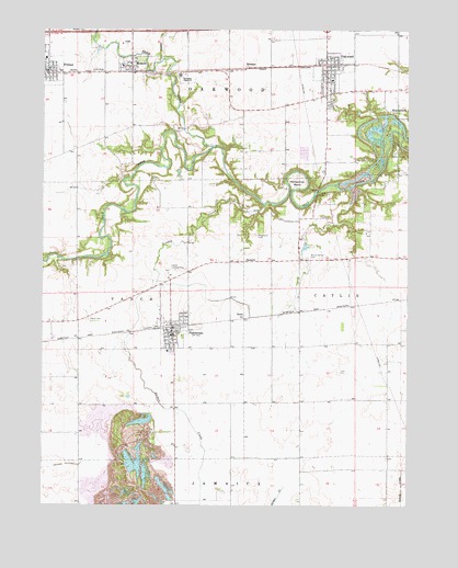
Oakwood, IL USGS Topographic Map
Click on map above to begin viewing in our Map Viewer.

This topographic map contains these locations and features:
Feature Name Type Latitude Longitude GNIS ID View Map
BennettPopulated PlaceN40.0642°W87.8061°422457View Map
BronsonPopulated PlaceN40.1150°W87.8053°404902View Map
Camp DrakeLocaleN40.0928°W87.7536°405465View Map
Cast AirportAirportN40.0384°W87.7823°427275View Map
Catlett Landing Strip (historical)AirportN40.0623°W87.8292°1719950View Map
Daugherty School (historical)SchoolN40.0139°W87.8295°1764455View Map
Davis CemeteryCemeteryN40.0487°W87.8593°406972View Map
Dougherty CemeteryCemeteryN40.0714°W87.8020°406961View Map
FairmountPopulated PlaceN40.0456°W87.8306°408182View Map
Fairmount - Vance Township Fire DepartmentBuildingN40.0447°W87.8302°2682307View Map
Fairmount Post OfficePost OfficeN40.0460°W87.8309°1983502View Map
Fairmount United Methodist ChurchChurchN40.0459°W87.8289°1983508View Map
Feather CreekStreamN40.1173°W87.8339°408308View Map
First Baptist ChurchChurchN40.0453°W87.8309°1983509View Map
FithianPopulated PlaceN40.1139°W87.8731°408411View Map
Fithian - Muncie - Collison Fire Protection DistrictBuildingN40.1146°W87.8743°2682548View Map
Fithian Post OfficePost OfficeN40.1156°W87.8731°1983494View Map
Fithian United Methodist ChurchChurchN40.1120°W87.8731°1983495View Map
Hickman CemeteryCemeteryN40.0749°W87.7923°410136View Map
Horseshoe BendBendN40.0856°W87.7884°410561View Map
Jordan CreekStreamN40.0000°W87.8209°411242View Map
Jordan School (historical)SchoolN40.0689°W87.8250°1764480View Map
Lakeshore School (historical)SchoolN40.1017°W87.8070°1719948View Map
Liberty School (historical)SchoolN40.0120°W87.8620°1764485View Map
Marvin Puzey LakeReservoirN40.0636°W87.8589°1691999View Map
Marvin Puzey Lake DamDamN40.0634°W87.8467°1691998View Map
MissionfieldPopulated PlaceN40.1048°W87.7536°413677View Map
Mount Vernon CemeteryCemeteryN40.0652°W87.7840°414092View Map
Mount Vernon Church (historical)SchoolN40.0650°W87.7836°1764490View Map
MunciePopulated PlaceN40.1156°W87.8448°414231View Map
Muncie Baptist ChurchChurchN40.1161°W87.8453°1983504View Map
Muncie Post OfficePost OfficeN40.1145°W87.8450°2788818View Map
OakwoodPopulated PlaceN40.1161°W87.7784°414923View Map
Oakwood Emergency Rescue ServiceBuildingN40.1040°W87.7777°2673956View Map
Oakwood Fire Protection DistrictBuildingN40.1082°W87.7786°2682547View Map
Oakwood First Evangelical Methodist ChurchChurchN40.1175°W87.7800°1983505View Map
Oakwood Grade SchoolSchoolN40.1120°W87.7761°1823634View Map
Oakwood High SchoolSchoolN40.1131°W87.8286°1719947View Map
Oakwood Post OfficePost OfficeN40.1149°W87.7767°1983503View Map
Oakwood Public LibraryBuildingN40.1145°W87.7770°1983506View Map
Oakwood United Methodist ChurchChurchN40.1175°W87.7781°1983507View Map
Pleasant Ridge (historical)ChurchN40.0281°W87.7570°1764497View Map
Pleasant Valley School (historical)SchoolN40.0403°W87.8628°1764498View Map
Pleasant View School (historical)SchoolN40.0414°W87.7872°1764500View Map
Ross School (historical)SchoolN40.0128°W87.7861°1764505View Map
RyanPopulated PlaceN40.0503°W87.8061°423144View Map
Singing BridgeBridgeN40.0820°W87.7811°425496View Map
Stony CreekStreamN40.0945°W87.8167°424550View Map
Sugar Grove School (historical)SchoolN40.0639°W87.7870°1719949View Map
Taylor School (historical)SchoolN40.0464°W87.7522°1764513View Map
Village of FairmountCivilN40.0456°W87.8293°2398856View Map
Village of FithianCivilN40.1144°W87.8750°2398881View Map
Village of MuncieCivilN40.1161°W87.8430°2399427View Map
Village of OakwoodCivilN40.1101°W87.7769°2399547View Map
Webster School (historical)SchoolN40.1242°W87.7542°1764520View Map

Note: Coordinates in the location and feature list above are referenced to NAD83 datum.


Copyright (C) 2008-2024 Ryan Niemi / Sunset Dynamics ... All Rights Reserved