TopoQuest Logo
Do you find TopoQuest useful?
Help keep TopoQuest running and adding new maps/features by donating!
Bitcoin:  19c7KJd3qBynnjoSw5npx9KScwjBe4ifkT
Litecoin:  LXs6TkuXGGXo1vDsWCkWVdjQX94eUKd6ui
Home View Maps Find Maps Find Places Resources & Links


Oakdale, California Topographic Map

USGS Map Title: Oakdale, CA
USGS Map MRC: 37120G7
DRG (GeoTIFF) Download: o37120g7.tif


Neighboring USGS Topographic Map Quads:


  Farmington, CA  
37120H8
 

  Bachelor Valley, CA  
37120H7
 

  Copperopolis, CA  
37120H6
 

  Escalon, CA  
37120G8
 

  Oakdale, CA  
37120G7
 

  Knights Ferry, CA  
37120G6
 

  Riverbank, CA  
37120F8
 

  Waterford, CA  
37120F7
 

  Paulsell, CA  
37120F6


Map MRC Location:

N38°
W121°
N38°
W120°
H8 H7 H6 H5 H4 H3 H2 H1
G8 G7 G6 G5 G4 G3 G2 G1
F8 F7 F6 F5 F4 F3 F2 F1
E8 E7 E6 E5 E4 E3 E2 E1
D8 D7 D6 D5 D4 D3 D2 D1
C8 C7 C6 C5 C4 C3 C2 C1
B8 B7 B6 B5 B4 B3 B2 B1
A8 A7 A6 A5 A4 A3 A2 A1
N37°
W121°
N37°
W120°

Oakdale, CA USGS 1:24K Topographic Map Preview:
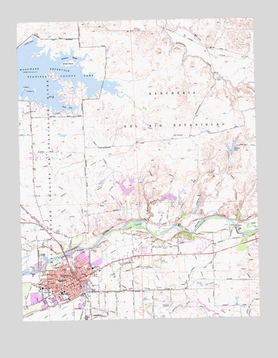
Oakdale, CA USGS Topographic Map
Click on map above to begin viewing in our Map Viewer.

This topographic map contains these locations and features:
Feature Name Type Latitude Longitude GNIS ID View Map
Adams LateralCanalN37.7627°W120.8155°217973View Map
AdelaPopulated PlaceN37.7885°W120.8633°1657888View Map
Birnbaum LateralCanalN37.7583°W120.8749°219321View Map
Biscuit PointCapeN37.8444°W120.8572°219325View Map
Booth School (historical)SchoolN37.7549°W120.7572°1816878View Map
Brennan ParkParkN37.7647°W120.8399°1817205View Map
Burnett LateralCanalN37.7913°W120.8691°220197View Map
Church of ChristChurchN37.7680°W120.8494°1817206View Map
Citizens CemeteryCemeteryN37.7627°W120.8383°221122View Map
City of OakdaleCivilN37.7617°W120.8462°2411291View Map
Clavey LateralCanalN37.7547°W120.7735°221176View Map
Clavey SiphonCanalN37.7722°W120.7830°221177View Map
Cloverland Elementary SchoolSchoolN37.7716°W120.8387°221260View Map
Cocklebur BeachBeachN37.8669°W120.8702°254753View Map
Collins LateralCanalN37.7999°W120.8244°233699View Map
Dixon LateralCanalN37.7810°W120.7947°222439View Map
Dorada ParkParkN37.7716°W120.8516°222517View Map
Dorsey LateralCanalN37.7924°W120.8433°222529View Map
Duck CoveBayN37.8391°W120.8499°222677View Map
East Clavey LateralCanalN37.7633°W120.7760°222870View Map
East OakdalePopulated PlaceN37.7880°W120.8038°1853386View Map
East Oakdale Census Designated PlaceCensusN37.7854°W120.8007°2408714View Map
East Pump LateralCanalN37.7741°W120.7749°222919View Map
Eastside SchoolSchoolN37.7683°W120.8416°222950View Map
Eaton LateralCanalN37.7921°W120.7933°233828View Map
Erickson SloughBayN37.8599°W120.8477°223232View Map
Fair Oaks Elementary SchoolSchoolN37.7637°W120.8652°223319View Map
Fair Oaks ParkParkN37.7652°W120.8635°1817209View Map
First Baptist ChurchChurchN37.7666°W120.8497°1817213View Map
First Church of Christ ScientistChurchN37.7683°W120.8499°1817215View Map
Free Methodist ChurchChurchN37.7644°W120.8499°1817216View Map
Gilbert ParkParkN37.7724°W120.8419°224163View Map
Gray LateralCanalN37.7713°W120.7569°224520View Map
Hi Line LateralCanalN37.8019°W120.8299°225228View Map
Hoekstra DairyLocaleN37.7744°W120.7953°2703319View Map
Kerr ParkParkN37.7888°W120.8166°226535View Map
Lesnini CreekStreamN37.7888°W120.7938°227032View Map
Lesnini LateralCanalN37.8041°W120.7633°227033View Map
Magnolia Elementary SchoolSchoolN37.7669°W120.8568°237567View Map
Martells CreekStreamN37.8735°W120.7960°228160View Map
Oak Valley Care CenterBuildingN37.7591°W120.8603°2656312View Map
Oak Valley HospitalHospitalN37.7577°W120.8610°1817226View Map
Oak Valley ParkParkN37.7566°W120.8608°1817227View Map
OakdalePopulated PlaceN37.7666°W120.8472°277564View Map
Oakdale Adult Education SchoolSchoolN37.7610°W120.8566°1817228View Map
Oakdale AirportAirportN37.7569°W120.7995°1653771View Map
Oakdale Branch Stanislaus County Free LibraryBuildingN37.7647°W120.8488°1817229View Map
Oakdale BridgeBridgeN37.7774°W120.8533°1662146View Map
Oakdale City Fire Department Station 1BuildingN37.7650°W120.8467°2623695View Map
Oakdale City Fire Department Station 2BuildingN37.7549°W120.8700°2624249View Map
Oakdale City HallBuildingN37.7683°W120.8497°1817230View Map
Oakdale DivisionCivilN37.8405°W120.7965°1935226View Map
Oakdale Golf and Country ClubLocaleN37.7813°W120.8135°1817231View Map
Oakdale Joint Union High SchoolSchoolN37.7616°W120.8543°236807View Map
Oakdale Junior High SchoolSchoolN37.7663°W120.8287°1817232View Map
Oakdale LateralCanalN37.7855°W120.7738°229884View Map
Oakdale North Main CanalCanalN37.8102°W120.7994°229885View Map
Oakdale Police DepartmentBuildingN37.7681°W120.8496°2755834View Map
Oakdale Post OfficePost OfficeN37.7652°W120.8533°2760176View Map
Oakdale Recreation AreaParkN37.7755°W120.8705°1817233View Map
Oakdale Rodeo GroundsParkN37.7763°W120.8319°1817234View Map
Oakdale Rural Fire Protection District Station 1BuildingN37.7724°W120.8337°2624240View Map
Oakdale Sewage PlantLocaleN37.7763°W120.8655°1662147View Map
Oakdale South Main CanalCanalN37.7569°W120.7858°229889View Map
Oakdale Sportsman ClubLocaleN37.7866°W120.8224°1817235View Map
Orange Blossom BridgeBridgeN37.7883°W120.7627°1816914View Map
Orange Blossom Recreation AreaParkN37.7894°W120.7630°1817236View Map
Peart LateralCanalN37.7905°W120.7574°230445View Map
Pentecostal Church of GodChurchN37.7691°W120.8472°1817245View Map
Rancheria Del Rio EstanislaoCivilN37.8374°W120.7952°231218View Map
Rodden CreekStreamN37.7896°W120.8094°231796View Map
Rodden LakeReservoirN37.8202°W120.7636°231797View Map
Rodden Lake 62-003 DamDamN37.8183°W120.7652°1663495View Map
Rodden LateralCanalN37.7946°W120.8499°231798View Map
Saint Lukes Lutheran ChurchChurchN37.7638°W120.8524°1817249View Map
Saint Marys Roman Catholic ChurchChurchN37.7702°W120.8499°1817250View Map
Saint Matthias Episcopal ChurchChurchN37.7655°W120.8491°1817251View Map
San Joaquin Main CanalCanalN37.8274°W120.7699°232410View Map
Santa Fe ParkParkN37.7613°W120.8449°1817252View Map
Seventh Day Adventist ChurchChurchN37.7647°W120.8474°1817253View Map
Stanislaus County ParkParkN37.8502°W120.8530°235366View Map
Stevenot LateralCanalN37.8158°W120.8347°235452View Map
T IslandIslandN37.8469°W120.8724°235949View Map
Towne East LateralCanalN37.7660°W120.8652°236485View Map
Townhill LateralCanalN37.7538°W120.8310°236486View Map
Truth for Today ChurchChurchN37.7644°W120.8516°1817256View Map
Tulloch LateralCanalN37.8063°W120.8619°236614View Map
U-3 RanchLocaleN37.8502°W120.7708°236751View Map
Valley Oak Recreation AreaParkN37.7869°W120.8024°1817259View Map
Walnut Woods Shopping CenterLocaleN37.7841°W120.8597°1817261View Map
West Pump LateralCanalN37.7719°W120.8122°237515View Map
Whale IslandIslandN37.8580°W120.8480°237586View Map
William Meyer ParkParkN37.7647°W120.8485°1817262View Map
Wood ParkParkN37.7658°W120.8460°238114View Map
Woodward ReservoirReservoirN37.8513°W120.8642°238176View Map
Wyatt LateralCanalN37.8180°W120.8602°238210View Map
Young LateralCanalN37.8177°W120.8552°238282View Map

Note: Coordinates in the location and feature list above are referenced to NAD83 datum.


Copyright (C) 2008-2024 Ryan Niemi / Sunset Dynamics ... All Rights Reserved