TopoQuest Logo
Do you find TopoQuest useful?
Help keep TopoQuest running and adding new maps/features by donating!
Bitcoin:  19c7KJd3qBynnjoSw5npx9KScwjBe4ifkT
Litecoin:  LXs6TkuXGGXo1vDsWCkWVdjQX94eUKd6ui
Home View Maps Find Maps Find Places Resources & Links


Oak Hill, Florida Topographic Map

USGS Map Title: Oak Hill, FL
USGS Map MRC: 28080G7
DRG (GeoTIFF) Download: o28080g7.tif


Neighboring USGS Topographic Map Quads:


  Edgewater, FL  
28080H8
 

  Ariel, FL  
28080H7


  Maytown, FL  
28080G8
 

  Oak Hill, FL  
28080G7
 

  Pardon Island, FL  
28080G6
 

  Aurantia, FL  
28080F8
 

  Mims, FL  
28080F7
 

  Wilson, FL  
28080F6


Map MRC Location:

N29°
W81°
N29°
W80°
H8 H7 H6 H5 H4 H3 H2 H1
G8 G7 G6 G5 G4 G3 G2 G1
F8 F7 F6 F5 F4 F3 F2 F1
E8 E7 E6 E5 E4 E3 E2 E1
D8 D7 D6 D5 D4 D3 D2 D1
C8 C7 C6 C5 C4 C3 C2 C1
B8 B7 B6 B5 B4 B3 B2 B1
A8 A7 A6 A5 A4 A3 A2 A1
N28°
W81°
N28°
W80°

Oak Hill, FL USGS 1:24K Topographic Map Preview:
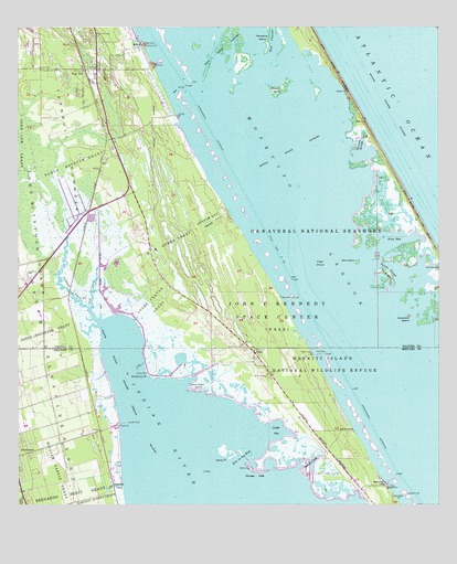
Oak Hill, FL USGS Topographic Map
Click on map above to begin viewing in our Map Viewer.

This topographic map contains these locations and features:
Feature Name Type Latitude Longitude GNIS ID View Map
Antelm Gay GrantCivilN28.8244°W80.8176°277905View Map
Apollo BeachBeachN28.8744°W80.7873°297444View Map
Beacon CampLocaleN28.7564°W80.7656°278267View Map
Bibleway Church of God in ChristChurchN28.8553°W80.8548°2451268View Map
Big Flounder CreekStreamN28.7555°W80.8431°278672View Map
Bird IslandIslandN28.8136°W80.7739°278797View Map
Boathouse PointCapeN28.7839°W80.8362°279109View Map
Bull HillSummitN28.8705°W80.8373°279641View Map
Canaveral National SeashoreParkN28.7863°W80.7542°307730View Map
Cape Canaveral National CemeteryCemeteryN28.7593°W80.8614°2775473View Map
Cat HammockIslandN28.8125°W80.7517°280127View Map
Coot CreekStreamN28.8019°W80.8534°280785View Map
East ChannelChannelN28.8750°W80.7992°281962View Map
First Baptist ChurchChurchN28.8645°W80.8476°2451269View Map
Georges FlatsFlatN28.7594°W80.8034°283031View Map
Georges SloughBayN28.8446°W80.7729°283034View Map
Glory HoleBayN28.8198°W80.7624°283125View Map
Grassy PointCapeN28.7622°W80.8123°283333View Map
Griffis BayBayN28.7696°W80.7978°283451View Map
H M Gomez GrantCivilN28.8180°W80.8289°283576View Map
Hole in the WallChannelN28.7633°W80.8076°294035View Map
Joseph Delespine GrantCivilN28.7864°W80.8676°284937View Map
Kings Trailer ParkPopulated PlaceN28.8438°W80.8473°2451262View Map
Kuhl DockLocaleN28.7894°W80.7842°285185View Map
Lucas Crayon GrantCivilN28.8028°W80.8342°286189View Map
Lyratta DockLocaleN28.7719°W80.8426°286232View Map
Macedonia Missionary Baptist ChurchChurchN28.8397°W80.8484°2451270View Map
Middle IslandIslandN28.8594°W80.7964°286799View Map
Mosquito LagoonBayN28.8050°W80.7685°307751View Map
Mosquito Lagoon Aquatic PreserveParkN28.7919°W80.7706°307759View Map
Oak HillPopulated PlaceN28.8644°W80.8545°287965View Map
Oak Hill Association Mobile Home ParkPopulated PlaceN28.8663°W80.8326°2451263View Map
Oak Hill CemeteryCemeteryN28.8706°W80.8586°2581962View Map
Oak Hill Police DepartmentBuildingN28.8588°W80.8513°2331484View Map
Oak Hill Post OfficePost OfficeN28.8638°W80.8500°2451260View Map
Oak Hill Trailer ParkPopulated PlaceN28.8473°W80.8482°2451264View Map
Onion Farm IslandIslandN28.7817°W80.8212°288159View Map
Orange Blossom Trailer ParkPopulated PlaceN28.8554°W80.8504°2451267View Map
Pablo Rosette GrantCivilN28.8397°W80.8548°288350View Map
Pattillo CreekStreamN28.7603°W80.7906°288580View Map
Plantation IslandIslandN28.8719°W80.8009°289026View Map
Preachers IslandIslandN28.7983°W80.7581°289296View Map
Saints CemeteryCemeteryN28.8536°W80.8441°2581987View Map
Shady Grove Church of GodChurchN28.8596°W80.8477°2451272View Map
ShilohPopulated PlaceN28.7905°W80.8045°295624View Map
Shiloh CampLocaleN28.7692°W80.7751°291024View Map
Sinners CemeteryCemeteryN28.8528°W80.8409°2581990View Map
South Mobile VillagePopulated PlaceN28.8732°W80.8552°2451266View Map
Tiger ShoalBayN28.8122°W80.7851°292288View Map
Tradewinds AerodromeAirportN28.7616°W80.8490°309889View Map
Turnbull CreekStreamN28.7983°W80.8503°292552View Map
Upper Room ChapelChurchN28.8672°W80.8471°2451273View Map
Vanns IslandIslandN28.8108°W80.7648°292736View Map
Vanns SloughBayN28.8117°W80.7627°292737View Map
Volusia County Fire Services Station 22 Oak HillBuildingN28.8703°W80.8509°2331216View Map
Volusia County Public Library System Oak Hill Public LibraryBuildingN28.8638°W80.8500°2451259View Map
W F Burns Oak Hill Elementary SchoolSchoolN28.8617°W80.8489°299360View Map
WGNE-FM (Titusville)TowerN28.8486°W80.8620°310269View Map
William Garvin GrantCivilN28.7592°W80.8681°293309View Map

Note: Coordinates in the location and feature list above are referenced to NAD83 datum.


Copyright (C) 2008-2024 Ryan Niemi / Sunset Dynamics ... All Rights Reserved