TopoQuest Logo
Do you find TopoQuest useful?
Help keep TopoQuest running and adding new maps/features by donating!
Bitcoin:  19c7KJd3qBynnjoSw5npx9KScwjBe4ifkT
Litecoin:  LXs6TkuXGGXo1vDsWCkWVdjQX94eUKd6ui
Home View Maps Find Maps Find Places Resources & Links


Northeast Bluff, Maine Topographic Map

USGS Map Title: Northeast Bluff, ME
USGS Map MRC: 44067G8
DRG (GeoTIFF) Download: o44067g8.tif


Neighboring USGS Topographic Map Quads:


  Quillpig Mountain, ME  
44068H1
 

  Peaked Mountain, ME  
44067H8
 

  Tug Mountain, ME  
44067H7
 

  Lead Mountain, ME  
44068G1
 

  Northeast Bluff, ME  
44067G8
 

  Montegail Pond, ME  
44067G7
 

  Tunk Mountain, ME  
44068F1
 

  Schoodic Lake, ME  
44067F8
 

  Epping, ME  
44067F7


Map MRC Location:

N45°
W68°
N45°
W67°
H8 H7 H6 H5 H4 H3 H2 H1
G8 G7 G6 G5 G4 G3 G2 G1
F8 F7 F6 F5 F4 F3 F2 F1
E8 E7 E6 E5 E4 E3 E2 E1
D8 D7 D6 D5 D4 D3 D2 D1
C8 C7 C6 C5 C4 C3 C2 C1
B8 B7 B6 B5 B4 B3 B2 B1
A8 A7 A6 A5 A4 A3 A2 A1
N44°
W68°
N44°
W67°

Northeast Bluff, ME USGS 1:24K Topographic Map Preview:
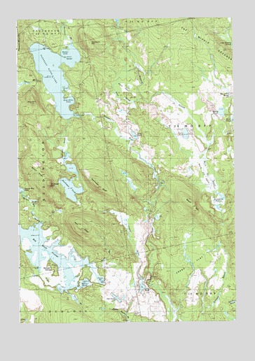
Northeast Bluff, ME USGS Topographic Map
Click on map above to begin viewing in our Map Viewer.

This topographic map contains these locations and features:
Feature Name Type Latitude Longitude GNIS ID View Map
Allen BrookStreamN44.8412°W67.9275°561179View Map
Allen HeathSwampN44.8437°W67.9336°561183View Map
Allison Worcester CampLocaleN44.7981°W67.9231°561211View Map
Beech HillSummitN44.7974°W67.8995°561985View Map
Beech Hill BrookStreamN44.8231°W67.8897°561990View Map
Beech Hill HeathSwampN44.8170°W67.9008°561991View Map
Bog Brook FlowageReservoirN44.7791°W67.9821°581646View Map
Bridgham SwampSwampN44.7998°W67.8856°562958View Map
Canoe BrookStreamN44.8512°W67.9853°563458View Map
Colonel BrookStreamN44.7704°W67.9244°564245View Map
Crebo FlatFlatN44.7720°W67.9047°564506View Map
Davis CampLocaleN44.7798°W67.9239°564803View Map
Dick Allen CoveBayN44.8415°W67.9700°565088View Map
Dorman IslandIslandN44.7723°W67.9792°565215View Map
Elsie PointCapeN44.8604°W67.9756°565880View Map
Flynn BrookStreamN44.7756°W67.9753°566336View Map
Flynn PondLakeN44.7680°W67.9533°566337View Map
Goose PondLakeN44.8362°W67.8818°566930View Map
Hall RidgeRidgeN44.7881°W67.9631°567517View Map
Hartford CampLocaleN44.8423°W67.8781°567708View Map
Irving Worcester CampLocaleN44.8267°W67.9542°568683View Map
Knox HillSummitN44.8409°W67.9913°569267View Map
Long PondLakeN44.7644°W67.9291°570280View Map
Merrit BrookStreamN44.7754°W67.9756°571173View Map
Merrit PondLakeN44.7663°W67.9621°571174View Map
Morse CampLocaleN44.7590°W67.9350°571695View Map
Morse CampLocaleN44.7726°W67.9511°571696View Map
Northeast BluffCliffN44.8062°W67.9558°572433View Map
Northeast BrookStreamN44.8648°W67.9689°572434View Map
Northeast HillSummitN44.8654°W67.9576°572444View Map
Oak PondLakeN44.7599°W67.9437°572631View Map
Otter PondLakeN44.8268°W67.9323°572834View Map
Parker CoveBayN44.8620°W67.9733°572971View Map
Pineo CampLocaleN44.7937°W67.8819°573411View Map
Pleasant River LakeReservoirN44.8524°W67.9771°573519View Map
Pleasant River Lake Water DamDamN44.8351°W67.9631°1773971View Map
Pretty PondLakeN44.8274°W67.9029°573805View Map
Southwest BluffCliffN44.8073°W67.9811°575943View Map
Southwest BrookStreamN44.8345°W67.9714°575947View Map
Southwest PondLakeN44.8052°W67.9695°575959View Map
Sprague CampLocaleN44.7590°W67.9189°576072View Map
Spruce Mountain Lake BrookStreamN44.7854°W67.9925°576151View Map
Spruce RidgeRidgeN44.8137°W67.9908°576163View Map
Stewart CampLocaleN44.7859°W67.9714°576338View Map
T24 MD BPPCivilN44.8371°W67.8869°1987567View Map

Note: Coordinates in the location and feature list above are referenced to NAD83 datum.


Copyright (C) 2008-2024 Ryan Niemi / Sunset Dynamics ... All Rights Reserved