TopoQuest Logo
Do you find TopoQuest useful?
Help keep TopoQuest running and adding new maps/features by donating!
Bitcoin:  19c7KJd3qBynnjoSw5npx9KScwjBe4ifkT
Litecoin:  LXs6TkuXGGXo1vDsWCkWVdjQX94eUKd6ui
Home View Maps Find Maps Find Places Resources & Links


Norma, Tennessee Topographic Map

USGS Map Title: Norma, TN
USGS Map MRC: 36084C4
DRG (GeoTIFF) Download: o36084c4.tif


Neighboring USGS Topographic Map Quads:


  Oneida South, TN  
36084D5
 

  Huntsville, TN  
36084D4
 

  Pioneer, TN  
36084D3
 

  Robbins, TN  
36084C5
 

  Norma, TN  
36084C4
 

  Block, TN  
36084C3
 

  Gobey, TN  
36084B5
 

  Fork Mountain, TN  
36084B4
 

  Duncan Flats, TN  
36084B3


Map MRC Location:

N37°
W85°
N37°
W84°
H8 H7 H6 H5 H4 H3 H2 H1
G8 G7 G6 G5 G4 G3 G2 G1
F8 F7 F6 F5 F4 F3 F2 F1
E8 E7 E6 E5 E4 E3 E2 E1
D8 D7 D6 D5 D4 D3 D2 D1
C8 C7 C6 C5 C4 C3 C2 C1
B8 B7 B6 B5 B4 B3 B2 B1
A8 A7 A6 A5 A4 A3 A2 A1
N36°
W85°
N36°
W84°

Norma, TN USGS 1:24K Topographic Map Preview:
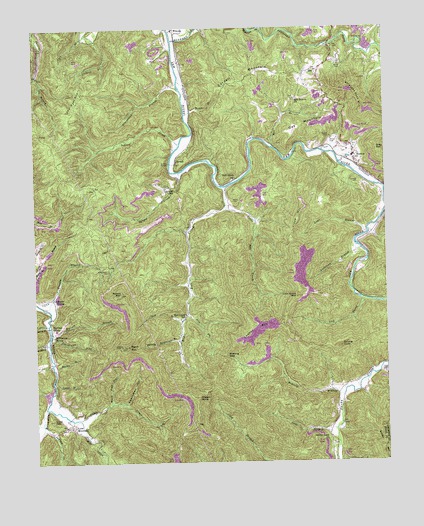
Norma, TN USGS Topographic Map
Click on map above to begin viewing in our Map Viewer.

This topographic map contains these locations and features:
Feature Name Type Latitude Longitude GNIS ID View Map
Allen MineMineN36.3098°W84.4813°1318753View Map
Anderson BranchStreamN36.3112°W84.3838°1275686View Map
Armstrong BranchStreamN36.3570°W84.4480°1275863View Map
Big Bull CreekStreamN36.3292°W84.4335°1305207View Map
Bowling BranchStreamN36.2692°W84.3905°1305359View Map
Bowling GapGapN36.2809°W84.4319°1278063View Map
Brimestone MineMineN36.2851°W84.4935°1318756View Map
Brimstone SidingLocaleN36.2867°W84.4941°1278400View Map
Bryd MineMineN36.3570°W84.3869°1318758View Map
Buffalo CreekStreamN36.3717°W84.4505°1327747View Map
Bull Creek Baptist ChurchChurchN36.3187°W84.4452°1318757View Map
Bull Creek SchoolSchoolN36.2929°W84.4466°1278947View Map
Bull Creek StationLocaleN36.3312°W84.4291°1278948View Map
Byrges Branch Baptist ChurchChurchN36.3292°W84.4516°1318759View Map
Byrges CreekStreamN36.3334°W84.4485°1305584View Map
Byrges SchoolSchoolN36.3292°W84.4516°1279262View Map
Calvin BranchStreamN36.2726°W84.4938°1279349View Map
Chimney HollowValleyN36.2864°W84.4946°1280472View Map
Claiborne-Cotton MineMineN36.3181°W84.4944°1318761View Map
Commissioner District 1CivilN36.3229°W84.4004°2464281View Map
CordellPopulated PlaceN36.3370°W84.4494°1314892View Map
Cordell BridgeBridgeN36.3362°W84.4516°1281287View Map
Cordell MountainSummitN36.3587°W84.4319°1281295View Map
Day MountainSummitN36.3473°W84.4044°1282222View Map
Dry ForkStreamN36.2931°W84.4458°1282960View Map
Frank Coker MineMineN36.2737°W84.4930°1318768View Map
Franks BranchStreamN36.2948°W84.4974°1284836View Map
Gibson KnobSummitN36.2687°W84.4424°1285352View Map
Goodman SidingLocaleN36.2976°W84.4944°1285648View Map
Griffith BranchStreamN36.3734°W84.4810°1286276View Map
Griffith BranchStreamN36.2845°W84.4955°1286277View Map
Hamon CemeteryCemeteryN36.3440°W84.3941°1286690View Map
Hatfield CemeteryCemeteryN36.3301°W84.3844°1287124View Map
Hutson BranchStreamN36.2876°W84.4949°1288875View Map
Indian CreekStreamN36.3420°W84.4480°1288950View Map
Indian CreekStreamN36.2609°W84.4980°1288963View Map
JeffersPopulated PlaceN36.3717°W84.3916°1652606View Map
Joel Dyer MountainSummitN36.3565°W84.4827°1289473View Map
Kline MineMineN36.3217°W84.4985°1318780View Map
Lassie MineMineN36.2867°W84.4935°1318781View Map
Lawson MountainSummitN36.2895°W84.4227°1290816View Map
Lick CreekStreamN36.2967°W84.3841°1291207View Map
Lick Creek MountainSummitN36.2976°W84.4066°1291224View Map
Little Bull CreekStreamN36.3229°W84.4319°1291407View Map
Little CreekStreamN36.2659°W84.4969°1291449View Map
Lloyd MountainSummitN36.3206°W84.4060°1291749View Map
Lone MountainSummitN36.2626°W84.4941°1291844View Map
Lone MountainPopulated PlaceN36.2606°W84.4897°1315429View Map
Lookout Tower Number SixteenTowerN36.2837°W84.4677°1647776View Map
Lowe BranchStreamN36.2595°W84.3935°1292194View Map
Lowe BranchStreamN36.3165°W84.3816°1292195View Map
Lowe CemeteryCemeteryN36.2756°W84.3755°1292201View Map
Martha BranchStreamN36.2773°W84.4938°1292783View Map
Martin MineMineN36.3215°W84.4019°1318785View Map
Mill BranchStreamN36.3406°W84.4149°1293804View Map
Mill Branch ChurchChurchN36.3545°W84.4072°1293814View Map
Mill CreekStreamN36.2629°W84.4858°1293848View Map
Muddy BranchStreamN36.2901°W84.4958°1295037View Map
New River MineMineN36.2787°W84.4930°1318790View Map
NormaPopulated PlaceN36.3370°W84.3855°1295816View Map
Norma Baptist ChurchChurchN36.3395°W84.3880°1318792View Map
Norma Division (historical)CensusN36.3165°W84.3938°1648940View Map
Norma Post OfficePost OfficeN36.3365°W84.3858°1651059View Map
Norma SchoolSchoolN36.3381°W84.3858°1318793View Map
Old House BranchStreamN36.2623°W84.4977°1296326View Map
Pemberton MineMineN36.2787°W84.4958°1318796View Map
Phillip CemeteryCemeteryN36.3251°W84.4297°1297318View Map
Phillip CemeteryCemeteryN36.3428°W84.3938°1297319View Map
Rector CemeteryCemeteryN36.3648°W84.3908°1299032View Map
Red Jacket MineMineN36.3140°W84.4991°1318798View Map
Rob Sexton CemeteryCemeteryN36.3051°W84.4738°1299585View Map
Robbins MineMineN36.2698°W84.4961°1318800View Map
Round MountainSummitN36.2981°W84.4694°1300167View Map
Salting KnobSummitN36.2829°W84.3919°1300598View Map
Schaefer-Goodman MineMineN36.3692°W84.4983°1318803View Map
Signal MountainSummitN36.2834°W84.4677°1303618View Map
Smoky Creek ChurchChurchN36.2554°W84.3947°1303695View Map
Smoky Creek SchoolSchoolN36.2704°W84.3924°1270723View Map
Sparkman HollowValleyN36.2671°W84.4685°1270955View Map
Split Chestnut HollowValleyN36.3613°W84.4986°1271015View Map
Spring Rockhouse BranchStreamN36.2851°W84.4488°1271130View Map
Stanley Walker MineMineN36.2954°W84.4716°1318807View Map
Sterling SidingLocaleN36.2890°W84.4947°1271346View Map
Straight ForkStreamN36.3745°W84.4180°1303874View Map
Straight Fork MineMineN36.3551°W84.3769°1318808View Map
Straight MountainSummitN36.3570°W84.3877°1271573View Map
Todd MineMineN36.2979°W84.4763°1318809View Map
Turkey BranchStreamN36.3504°W84.4463°1272991View Map
Walker MineMineN36.3001°W84.4749°1318811View Map
West Brothers MineMineN36.2751°W84.4927°1318812View Map
Wolf Pen HollowValleyN36.2669°W84.4736°1274972View Map
York BranchStreamN36.2909°W84.4477°1275303View Map

Note: Coordinates in the location and feature list above are referenced to NAD83 datum.


Copyright (C) 2008-2024 Ryan Niemi / Sunset Dynamics ... All Rights Reserved