TopoQuest Logo
Do you find TopoQuest useful?
Help keep TopoQuest running and adding new maps/features by donating!
Bitcoin:  19c7KJd3qBynnjoSw5npx9KScwjBe4ifkT
Litecoin:  LXs6TkuXGGXo1vDsWCkWVdjQX94eUKd6ui
Home View Maps Find Maps Find Places Resources & Links


Norfolk, New York Topographic Map

USGS Map Title: Norfolk, NY
USGS Map MRC: 44074G8
DRG (GeoTIFF) Download: o44074g8.tif


Neighboring USGS Topographic Map Quads:


  Louisville, NY  
44075H1
 

  Massena, NY  
44074H8
 

  Raquette River, NY  
44074H7
 

  Chase Mills, NY  
44075G1
 

  Norfolk, NY  
44074G8
 

  Brasher Falls, NY  
44074G7
 

  West Potsdam, NY  
44075F1
 

  Potsdam, NY  
44074F8
 

  Parishville, NY  
44074F7


Map MRC Location:

N45°
W75°
N45°
W74°
H8 H7 H6 H5 H4 H3 H2 H1
G8 G7 G6 G5 G4 G3 G2 G1
F8 F7 F6 F5 F4 F3 F2 F1
E8 E7 E6 E5 E4 E3 E2 E1
D8 D7 D6 D5 D4 D3 D2 D1
C8 C7 C6 C5 C4 C3 C2 C1
B8 B7 B6 B5 B4 B3 B2 B1
A8 A7 A6 A5 A4 A3 A2 A1
N44°
W75°
N44°
W74°

Norfolk, NY USGS 1:24K Topographic Map Preview:
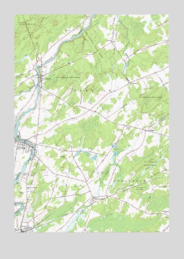
Norfolk, NY USGS Topographic Map
Click on map above to begin viewing in our Map Viewer.

This topographic map contains these locations and features:
Feature Name Type Latitude Longitude GNIS ID View Map
BrookdalePopulated PlaceN44.8084°W74.8916°976031View Map
Brookdale CemeteryCemeteryN44.8109°W74.9096°976032View Map
Church of the VisitationChurchN44.7996°W74.9903°2599061View Map
First Congregational ChurchChurchN44.7514°W74.9939°2495740View Map
GrantvillePopulated PlaceN44.8595°W74.9210°976358View Map
Hall CreekStreamN44.8459°W74.9821°976397View Map
Hepburn Library of NorfolkBuildingN44.8005°W74.9910°2597620View Map
Knapps Station Community ChurchChurchN44.7697°W74.9341°2597594View Map
Marble HillSummitN44.7934°W74.9585°976626View Map
NorfolkPopulated PlaceN44.8009°W74.9910°976729View Map
Norfolk Census Designated PlaceCensusN44.7923°W74.9866°2389558View Map
Norfolk Mobile Home ParkPopulated PlaceN44.8677°W74.9470°2599028View Map
Norfolk Post OfficePost OfficeN44.8010°W74.9829°2599010View Map
Norfolk Town Sewage District 1 Wastewater Treatment FacilityLocaleN44.8032°W74.9982°2597267View Map
Norfolk Volunteer Fire Department Station 1BuildingN44.8019°W74.9908°2735282View Map
Norfolk Volunteer Fire Department Station 2BuildingN44.8382°W74.9781°2735283View Map
Norfolk Volunteer Rescue SquadBuildingN44.7991°W74.9888°2720109View Map
Norfolk Wesleyan ChurchChurchN44.8011°W74.9910°2597614View Map
North StockholmPopulated PlaceN44.7695°W74.9346°976740View Map
NorwoodPopulated PlaceN44.7514°W74.9944°976744View Map
Norwood LibraryBuildingN44.7526°W74.9949°2599067View Map
Norwood Union School (historical)SchoolN44.7517°W74.9986°2495741View Map
Norwood-Norfolk SchoolSchoolN44.7753°W74.9885°976745View Map
Pine Grove Mobile Home ParkPopulated PlaceN44.7906°W74.9845°2599029View Map
PlumbrookPopulated PlaceN44.8356°W74.9069°976841View Map
RaymondvillePopulated PlaceN44.8381°W74.9780°976877View Map
Raymondville Golf and Country ClubLocaleN44.8505°W74.9739°2599053View Map
Raymondville Post OfficePost OfficeN44.8381°W74.9773°2599017View Map
Saint Raymond ChurchChurchN44.8422°W74.9769°2597610View Map
School Number 12 (historical)SchoolN44.7789°W74.9414°2120418View Map
School Number 13 (historical)SchoolN44.7700°W74.9186°2120419View Map
School Number 17 (historical)SchoolN44.8058°W74.8808°2120420View Map
School Number 2 (historical)SchoolN44.8203°W74.9389°2120415View Map
School Number 3 (historical)SchoolN44.8414°W74.8867°2120416View Map
School Number 6 (historical)SchoolN44.8594°W74.9208°2120417View Map
Town of NorfolkCivilN44.8320°W74.9467°979280View Map
Trout BrookStreamN44.8345°W74.9810°977137View Map
Wilbur HillSummitN44.7726°W74.9905°977274View Map
YalevillePopulated PlaceN44.7673°W74.9924°977305View Map

Note: Coordinates in the location and feature list above are referenced to NAD83 datum.


Copyright (C) 2008-2024 Ryan Niemi / Sunset Dynamics ... All Rights Reserved