TopoQuest Logo
Do you find TopoQuest useful?
Help keep TopoQuest running and adding new maps/features by donating!
Bitcoin:  19c7KJd3qBynnjoSw5npx9KScwjBe4ifkT
Litecoin:  LXs6TkuXGGXo1vDsWCkWVdjQX94eUKd6ui
Home View Maps Find Maps Find Places Resources & Links


Nisswa, Minnesota Topographic Map

USGS Map Title: Nisswa, MN
USGS Map MRC: 46094E3
DRG (GeoTIFF) Download: o46094e3.tif


Neighboring USGS Topographic Map Quads:


  Pine River, MN  
46094F4
 

  Jenkins, MN  
46094F3
 

  Lower Whitefish Lake, MN  
46094F2
 

  Pine River SW, MN  
46094E4
 

  Nisswa, MN  
46094E3
 

  Pelican Lake, MN  
46094E2
 

  Wilson Bay, MN  
46094D4
 

  Gull Lake, MN  
46094D3
 

  Merrifield, MN  
46094D2


Map MRC Location:

N47°
W95°
N47°
W94°
H8 H7 H6 H5 H4 H3 H2 H1
G8 G7 G6 G5 G4 G3 G2 G1
F8 F7 F6 F5 F4 F3 F2 F1
E8 E7 E6 E5 E4 E3 E2 E1
D8 D7 D6 D5 D4 D3 D2 D1
C8 C7 C6 C5 C4 C3 C2 C1
B8 B7 B6 B5 B4 B3 B2 B1
A8 A7 A6 A5 A4 A3 A2 A1
N46°
W95°
N46°
W94°

Nisswa, MN USGS 1:24K Topographic Map Preview:
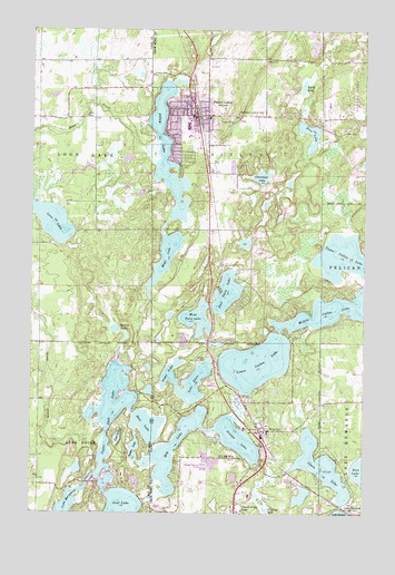
Nisswa, MN USGS Topographic Map
Click on map above to begin viewing in our Map Viewer.

This topographic map contains these locations and features:
Feature Name Type Latitude Longitude GNIS ID View Map
Bass LakeLakeN46.5225°W94.3316°639688View Map
Christ Community ChurchChurchN46.5156°W94.2875°2071562View Map
Church of the CrossChurchN46.5005°W94.2961°641212View Map
City of Lake ShoreCivilN46.5039°W94.3636°2395601View Map
City of NisswaCivilN46.5003°W94.2977°2395238View Map
City of Pequot LakesCivilN46.5875°W94.2984°2396180View Map
Clark LakeLakeN46.5123°W94.2656°641246View Map
Cloverleaf LakeLakeN46.5869°W94.2891°641360View Map
East Twin LakeLakeN46.5572°W94.3019°643113View Map
Fawn LakeLakeN46.5360°W94.3228°643584View Map
Fishtrap LakeLakeN46.5006°W94.2861°643711View Map
Fritz's Resort Golf CourseLocaleN46.5333°W94.3067°2071731View Map
Fritz's Resort Trailer ParkPopulated PlaceN46.5333°W94.3067°2071730View Map
Gloria Dei Lutheran ChurchChurchN46.5972°W94.3125°2071553View Map
Grace United Methodist ChurchChurchN46.5778°W94.3083°2071550View Map
Hubert (historical)LocaleN46.5022°W94.2572°2071693View Map
Kingdom Hall of Jehovah's WitnessesChurchN46.6031°W94.3139°2071548View Map
KLKS-FM (Breezy Point)TowerN46.6036°W94.2514°663287View Map
KLKS-FM (Breezy Point)TowerN46.6039°W94.2969°663288View Map
KTIG-FM (Pequot Lakes)TowerN46.6016°W94.3156°663317View Map
Lake EdnaLakeN46.5337°W94.3134°643186View Map
Lake HubertPopulated PlaceN46.5022°W94.2575°646364View Map
Lake Hubert Post OfficePost OfficeN46.5022°W94.2572°2071694View Map
Loon LakeLakeN46.5752°W94.3674°647174View Map
Loon Lake CamplandLocaleN46.5694°W94.3681°2071542View Map
Loon Lake Township DamDamN46.5900°W94.3336°1777021View Map
Lost LakeLakeN46.5197°W94.3423°647202View Map
Lower Cullen LakeLakeN46.5389°W94.2907°647248View Map
Lund LakeLakeN46.6112°W94.2726°647293View Map
Mayo CreekStreamN46.5950°W94.3281°647639View Map
Mayo LakeLakeN46.5663°W94.3249°647641View Map
Mayo LakeReservoirN46.5550°W94.3303°1775939View Map
Mayo Lake DamDamN46.5550°W94.3303°1775938View Map
Middle Cullen LakeLakeN46.5525°W94.2620°647807View Map
New Hope Community ChurchChurchN46.5222°W94.2875°2071561View Map
NisswaPopulated PlaceN46.5205°W94.2886°648560View Map
Nisswa (historical)LocaleN46.5225°W94.2903°2071555View Map
Nisswa CemeteryCemeteryN46.5216°W94.2805°648561View Map
Nisswa City HallBuildingN46.5217°W94.2886°2071559View Map
Nisswa City ParkParkN46.5231°W94.2886°2071554View Map
Nisswa Elementary SchoolSchoolN46.5207°W94.2862°2071558View Map
Nisswa Fire DepartmentBuildingN46.5243°W94.2906°2666683View Map
Nisswa LakeLakeN46.5193°W94.2976°648562View Map
Nisswa Pioneer VillageLocaleN46.5222°W94.2897°2071556View Map
Nisswa Police DepartmentBuildingN46.5224°W94.2884°2758681View Map
Nisswa Post OfficePost OfficeN46.5216°W94.2900°2071560View Map
Our Savior's Lutheran ChurchChurchN46.6028°W94.3144°2071551View Map
Our Saviour's CemeteryCemeteryN46.6025°W94.3167°2071520View Map
Pequot Family ClinicHospitalN46.6000°W94.3133°2071547View Map
Pequot LakesPopulated PlaceN46.6030°W94.3094°649276View Map
Pequot Lakes (historical)LocaleN46.6028°W94.3128°2071544View Map
Pequot Lakes Baptist ChurchChurchN46.5897°W94.3078°2071549View Map
Pequot Lakes CemeteryCemeteryN46.6022°W94.3181°2071519View Map
Pequot Lakes Fire DepartmentBuildingN46.6037°W94.3075°2071504View Map
Pequot Lakes High SchoolSchoolN46.6000°W94.3167°2071546View Map
Pequot Lakes Police DepartmentBuildingN46.6037°W94.3075°2071503View Map
Pequot Lakes Post OfficePost OfficeN46.6031°W94.3111°2071545View Map
Pequot Lookout TowerTowerN46.6039°W94.2967°659918View Map
Pequot TerracePopulated PlaceN46.5206°W94.2883°2071557View Map
Portview SchoolSchoolN46.5005°W94.3719°649685View Map
Rice LakeLakeN46.5934°W94.2716°650009View Map
Roy LakeLakeN46.5163°W94.3213°650370View Map
Saint Alice Catholic ChurchChurchN46.6022°W94.3097°2071552View Map
Saint Christopher's ChurchChurchN46.5231°W94.2861°2071563View Map
Sibley LakeLakeN46.5934°W94.3244°652009View Map
Sibley LakeReservoirN46.5750°W94.3253°1775953View Map
Sibley Lake DamDamN46.5750°W94.3253°1775952View Map
Spider LakeLakeN46.5165°W94.3364°652385View Map
Spring LakeLakeN46.5476°W94.3437°652468View Map
Stony BrookStreamN46.5225°W94.3517°652674View Map
Tall Timbers CampgroundLocaleN46.6125°W94.3264°2071543View Map
The Pines at Grand View Lodge Golf CourseLocaleN46.5069°W94.3139°2071728View Map
The Preserve at Grand View Lodge Golf CourseLocaleN46.5736°W94.2917°2071729View Map
Thorp-Heald CemeteryCemeteryN46.5022°W94.2533°2071564View Map
Township of Loon LakeCivilN46.5876°W94.3619°664824View Map
Township of SibleyCivilN46.5930°W94.3008°665607View Map
Upper Cullen LakeLakeN46.5664°W94.2571°653543View Map
Upper Gull LakeLakeN46.5268°W94.3448°653548View Map
West Twin LakeLakeN46.5502°W94.3129°654017View Map
Wildlife ImpoundmentReservoirN46.5900°W94.3336°1777022View Map
Wildwedge Family Golf ParkLocaleN46.6244°W94.3167°2071725View Map

Note: Coordinates in the location and feature list above are referenced to NAD83 datum.


Copyright (C) 2008-2024 Ryan Niemi / Sunset Dynamics ... All Rights Reserved