TopoQuest Logo
Do you find TopoQuest useful?
Help keep TopoQuest running and adding new maps/features by donating!
Bitcoin:  19c7KJd3qBynnjoSw5npx9KScwjBe4ifkT
Litecoin:  LXs6TkuXGGXo1vDsWCkWVdjQX94eUKd6ui
Home View Maps Find Maps Find Places Resources & Links


Newton Falls, Ohio Topographic Map

USGS Map Title: Newton Falls, OH
USGS Map MRC: 41080B8
DRG (GeoTIFF) Download: o41080b8.tif


Neighboring USGS Topographic Map Quads:


  Garrettsville, OH  
41081C1
 

  Southington, OH  
41080C8
 

  Champion, OH  
41080C7
 

  Windham, OH  
41081B1
 

  Newton Falls, OH  
41080B8
 

  Warren, OH  
41080B7
 

  Deerfield, OH  
41081A1
 

  Lake Milton, OH  
41080A8
 

  Canfield, OH  
41080A7


Map MRC Location:

N42°
W81°
N42°
W80°
H8 H7 H6 H5 H4 H3 H2 H1
G8 G7 G6 G5 G4 G3 G2 G1
F8 F7 F6 F5 F4 F3 F2 F1
E8 E7 E6 E5 E4 E3 E2 E1
D8 D7 D6 D5 D4 D3 D2 D1
C8 C7 C6 C5 C4 C3 C2 C1
B8 B7 B6 B5 B4 B3 B2 B1
A8 A7 A6 A5 A4 A3 A2 A1
N41°
W81°
N41°
W80°

Newton Falls, OH USGS 1:24K Topographic Map Preview:
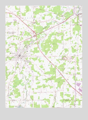
Newton Falls, OH USGS Topographic Map
Click on map above to begin viewing in our Map Viewer.

This topographic map contains these locations and features:
Feature Name Type Latitude Longitude GNIS ID View Map
Arhaven EstatesPopulated PlaceN41.2161°W80.9342°2513490View Map
Arlington HeightsPopulated PlaceN41.1864°W80.9684°1084514View Map
Arlington Public SchoolSchoolN41.1884°W80.9698°1084515View Map
Baileys CornersLocaleN41.1876°W80.8865°1064371View Map
Baldwin CornersLocaleN41.1253°W80.9251°1064375View Map
Blue Water ManorPopulated PlaceN41.1683°W80.9175°2513471View Map
BracevillePopulated PlaceN41.2284°W80.9545°1064473View Map
Braceville AirportAirportN41.2087°W80.9709°1082899View Map
Braceville Center CemeteryCemeteryN41.2245°W80.9573°1961521View Map
Braceville Post Office (historical)Post OfficeN41.2362°W80.9748°2059905View Map
Braceville RidgePopulated PlaceN41.2362°W80.9754°1050747View Map
Braceville Township Fire DepartmentBuildingN41.2289°W80.9548°2549573View Map
Center WorldPopulated PlaceN41.2284°W80.9098°1050752View Map
Craig Beach Police DepartmentBuildingN41.1274°W80.9792°2732670View Map
Duck CreekStreamN41.2389°W80.8818°1039843View Map
Duck CreekPopulated PlaceN41.1656°W80.8865°1064559View Map
Duck Creek CemeteryCemeteryN41.1395°W80.9195°1048326View Map
Duck Creek Post Office (historical)Post OfficeN41.1653°W80.8859°2059976View Map
East Newton Falls CemeteryCemeteryN41.1925°W80.9754°1961530View Map
First Christian ChurchChurchN41.1881°W80.9756°1084516View Map
First Congregational ChurchChurchN41.1898°W80.9748°1084517View Map
First Methodist Episcopal Church (historical)ChurchN41.1884°W80.9762°1084518View Map
German CemeteryCemeteryN41.1662°W80.9393°1961533View Map
Immanuel Missionary Church (historical)ChurchN41.1864°W80.9798°1084519View Map
Imperial Mobile Home ParkPopulated PlaceN41.1414°W80.8817°2513478View Map
Interchange 14CrossingN41.2181°W80.9534°1080248View Map
Kale CreekStreamN41.1606°W80.9726°1066779View Map
Labrae High SchoolSchoolN41.2395°W80.8779°1050753View Map
Labrae Middle SchoolSchoolN41.2323°W80.9540°1050750View Map
Lawson RunStreamN41.2098°W80.9468°1061995View Map
LeavittsburgPopulated PlaceN41.2478°W80.8770°1064978View Map
Leavittsburg Census Designated PlaceCensusN41.2453°W80.8788°2393095View Map
Leavittsburg Post OfficePost OfficeN41.2473°W80.8776°2056260View Map
Little Duck CreekStreamN41.2164°W80.8812°1042659View Map
Maderite HeightsPopulated PlaceN41.1789°W80.9748°1084520View Map
McCorkle CemeteryCemeteryN41.1272°W80.8759°1963273View Map
Middle Elementary SchoolSchoolN41.1834°W80.9695°1050745View Map
Milton DamDamN41.1276°W80.9773°1070846View Map
Newton FallsPopulated PlaceN41.1884°W80.9781°1065149View Map
Newton Falls City HallBuildingN41.1887°W80.9770°1084521View Map
Newton Falls Covered BridgeBridgeN41.1953°W80.9673°1069762View Map
Newton Falls DamDamN41.1967°W80.9665°1078211View Map
Newton Falls High SchoolSchoolN41.1773°W80.9572°1084149View Map
Newton Falls Joint Fire District Station 43BuildingN41.1888°W80.9770°2549847View Map
Newton Falls Junior High SchoolSchoolN41.1773°W80.9614°1050746View Map
Newton Falls Police DepartmentBuildingN41.1888°W80.9772°2732873View Map
Newton Falls Post OfficePost OfficeN41.1876°W80.9790°1084522View Map
Newton Falls ReservoirReservoirN41.1967°W80.9665°1078212View Map
Newton HeightsPopulated PlaceN41.1848°W80.9831°1084523View Map
Phalanx StationLocaleN41.2484°W80.9548°1044411View Map
Price Mill CemeteryCemeteryN41.1345°W80.9654°1961545View Map
PricetownPopulated PlaceN41.1342°W80.9665°1063399View Map
Pricetown United Methodist ChurchChurchN41.1342°W80.9654°1062021View Map
Ridge Branch CampgroundLocaleN41.2306°W80.9868°1050748View Map
Ridge HillSummitN41.2367°W80.9762°1063505View Map
RiverviewPopulated PlaceN41.1806°W80.9709°1084524View Map
Riverview Golf CourseLocaleN41.2270°W80.9395°1050751View Map
Rose ParkPopulated PlaceN41.1912°W80.9637°1084525View Map
Saint Josephs Catholic ChurchChurchN41.1864°W80.9826°1084526View Map
Saint Marys Roman Catholic ChurchChurchN41.1934°W80.9745°1084527View Map
Saint Michaels CemeteryCemeteryN41.1670°W80.9390°1045712View Map
Saint Michaels Greek Catholic ChurchChurchN41.1848°W80.9784°1084528View Map
South CanalPopulated PlaceN41.1773°W80.9868°1867467View Map
South Canal Census Designated PlaceCensusN41.1759°W80.9864°2393239View Map
TigerPopulated PlaceN41.1342°W80.9059°1062597View Map
Tiger Post Office (historical)Post OfficeN41.1348°W80.9054°2035724View Map
Township of BracevilleCivilN41.2377°W80.9542°1087024View Map
Township of NewtonCivilN41.1689°W80.9543°1087041View Map
Township of WarrenCivilN41.2152°W80.8822°1087047View Map
Trumbull Correctional CenterBuildingN41.2320°W80.8879°2722711View Map
Vaughn Elementary SchoolSchoolN41.2334°W80.9529°1050749View Map
Village of Newton FallsCivilN41.1886°W80.9701°2395230View Map
Warren Township Fire Department Station 47BuildingN41.2401°W80.8782°2549834View Map
West Branch Mahoning RiverStreamN41.2078°W80.9556°1067047View Map
West Branch ParkLocaleN41.1870°W80.9987°1047738View Map
West Newton Falls CemeteryCemeteryN41.1937°W80.9773°1961554View Map
West River ParkPopulated PlaceN41.1881°W80.9868°1084529View Map
West ViewPopulated PlaceN41.1962°W80.9762°1084530View Map
Wilderson CemeteryCemeteryN41.1785°W80.9269°1047910View Map

Note: Coordinates in the location and feature list above are referenced to NAD83 datum.


Copyright (C) 2008-2024 Ryan Niemi / Sunset Dynamics ... All Rights Reserved