TopoQuest Logo
Do you find TopoQuest useful?
Help keep TopoQuest running and adding new maps/features by donating!
Bitcoin:  19c7KJd3qBynnjoSw5npx9KScwjBe4ifkT
Litecoin:  LXs6TkuXGGXo1vDsWCkWVdjQX94eUKd6ui
Home View Maps Find Maps Find Places Resources & Links


Newberry NW, South Carolina Topographic Map

USGS Map Title: Newberry NW, SC
USGS Map MRC: 34081D6
DRG (GeoTIFF) Download: o34081d6.tif


Neighboring USGS Topographic Map Quads:


  Philson Crossroads, SC  
34081E7
 

  Sedalia, SC  
34081E6
 

  Whitmire North, SC  
34081E5
 

  Joanna, SC  
34081D7
 

  Newberry NW, SC  
34081D6
 

  Whitmire South, SC  
34081D5
 

  Bush River, SC  
34081C7
 

  Newberry West, SC  
34081C6
 

  Newberry East, SC  
34081C5


Map MRC Location:

N35°
W82°
N35°
W81°
H8 H7 H6 H5 H4 H3 H2 H1
G8 G7 G6 G5 G4 G3 G2 G1
F8 F7 F6 F5 F4 F3 F2 F1
E8 E7 E6 E5 E4 E3 E2 E1
D8 D7 D6 D5 D4 D3 D2 D1
C8 C7 C6 C5 C4 C3 C2 C1
B8 B7 B6 B5 B4 B3 B2 B1
A8 A7 A6 A5 A4 A3 A2 A1
N34°
W82°
N34°
W81°

Newberry NW, SC USGS 1:24K Topographic Map Preview:
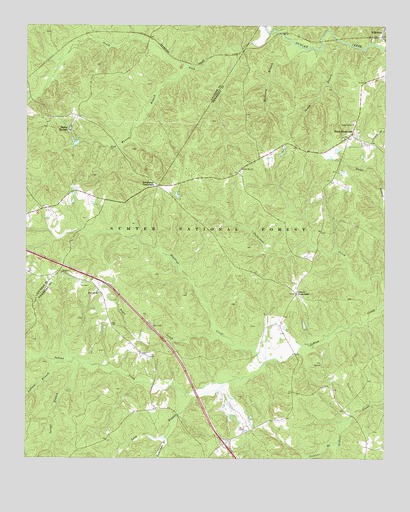
Newberry NW, SC USGS Topographic Map
Click on map above to begin viewing in our Map Viewer.

This topographic map contains these locations and features:
Feature Name Type Latitude Longitude GNIS ID View Map
Brick House CampgroundLocaleN34.4476°W81.7068°1252017View Map
Brickhouse CrossroadsPopulated PlaceN34.4537°W81.7037°1246983View Map
Buncombe BranchStreamN34.3812°W81.7009°1229487View Map
Cedar Grove ChurchChurchN34.4721°W81.6357°1247212View Map
Cedar Grove ChurchChurchN34.4271°W81.6540°1228394View Map
Cedar Grove School (historical)SchoolN34.4726°W81.6354°1228395View Map
Cromer CrossroadsPopulated PlaceN34.4229°W81.6554°1247427View Map
Cromer School (historical)SchoolN34.3960°W81.6459°1228402View Map
Drysacks BranchStreamN34.4268°W81.6934°1252187View Map
Eison CrossroadsPopulated PlaceN34.4687°W81.6362°1247645View Map
Fairview CemeteryCemeteryN34.4227°W81.7244°1228414View Map
Fairview ChurchChurchN34.4229°W81.7243°1247711View Map
Flannigans BranchStreamN34.4929°W81.6751°1252164View Map
Flint Hill ChurchChurchN34.4585°W81.6746°1247781View Map
Flint Hill School (historical)SchoolN34.4587°W81.6748°1228417View Map
Flinthill CemeteryCemeteryN34.4576°W81.6751°1228418View Map
Garlington (historical)Populated PlaceN34.4932°W81.6748°1234824View Map
Garlington School (historical)SchoolN34.4999°W81.7001°1234825View Map
Georges BranchStreamN34.4037°W81.7326°1252189View Map
Gilliam Chapel School (historical)SchoolN34.4090°W81.6854°1228419View Map
Headleys CreekStreamN34.4029°W81.6668°1229783View Map
Interchange 66CrossingN34.3793°W81.6804°1228189View Map
Joshuas BranchStreamN34.3804°W81.6407°1229872View Map
Locust BranchStreamN34.4024°W81.7307°1229943View Map
Loftons BranchStreamN34.4029°W81.7348°1229944View Map
Long BranchStreamN34.3968°W81.6793°1229948View Map
Mount Table School (historical)SchoolN34.4676°W81.6290°1228759View Map
Mount Tabor CemeteryCemeteryN34.4660°W81.6337°1235328View Map
Mount Tabor Church (historical)ChurchN34.4671°W81.6334°1252193View Map
Mulberry BranchStreamN34.4937°W81.6548°1224878View Map
Ned Wesson BranchStreamN34.4882°W81.6934°1230086View Map
Peges CreekStreamN34.4110°W81.6818°1250051View Map
Sandy BranchStreamN34.4943°W81.6373°1230294View Map
South Fork Duncan CreekStreamN34.4979°W81.6654°1230344View Map
Stomp SpringsPopulated PlaceN34.4699°W81.7343°1231833View Map
Tabernacle ChurchChurchN34.4229°W81.7246°1228837View Map
Tabernacle Church (historical)ChurchN34.4162°W81.7209°1252194View Map
Tabernacle School (historical)SchoolN34.4171°W81.7212°1228838View Map
Zion CemeteryCemeteryN34.4026°W81.6468°1228854View Map
Zion ChurchChurchN34.4024°W81.6465°1251554View Map

Note: Coordinates in the location and feature list above are referenced to NAD83 datum.


Copyright (C) 2008-2024 Ryan Niemi / Sunset Dynamics ... All Rights Reserved