TopoQuest Logo
Do you find TopoQuest useful?
Help keep TopoQuest running and adding new maps/features by donating!
Bitcoin:  19c7KJd3qBynnjoSw5npx9KScwjBe4ifkT
Litecoin:  LXs6TkuXGGXo1vDsWCkWVdjQX94eUKd6ui
Home View Maps Find Maps Find Places Resources & Links


New Empire, Nevada Topographic Map

USGS Map Title: New Empire, NV
USGS Map MRC: 39119B6
DRG (GeoTIFF) Download: o39119b6.tif


Neighboring USGS Topographic Map Quads:


  Washoe City, NV  
39119C7
 

  Virginia City, NV  
39119C6
 

  Flowery Peak, NV  
39119C5
 

  Carson City, NV  
39119B7
 

  New Empire, NV  
39119B6
 

  Dayton, NV  
39119B5
 

  Genoa, NV  
39119A7
 

  McTarnahan Hill, NV  
39119A6
 

  Mineral Peak, NV  
39119A5


Map MRC Location:

N40°
W120°
N40°
W119°
H8 H7 H6 H5 H4 H3 H2 H1
G8 G7 G6 G5 G4 G3 G2 G1
F8 F7 F6 F5 F4 F3 F2 F1
E8 E7 E6 E5 E4 E3 E2 E1
D8 D7 D6 D5 D4 D3 D2 D1
C8 C7 C6 C5 C4 C3 C2 C1
B8 B7 B6 B5 B4 B3 B2 B1
A8 A7 A6 A5 A4 A3 A2 A1
N39°
W120°
N39°
W119°

New Empire, NV USGS 1:24K Topographic Map Preview:
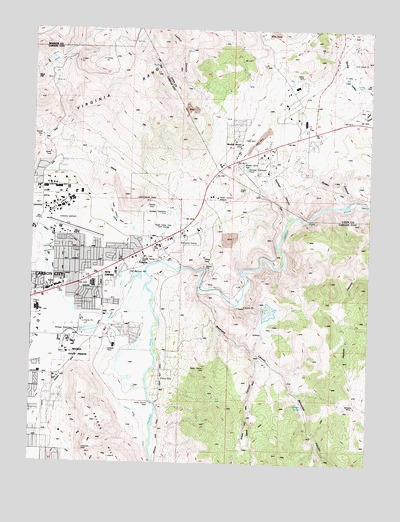
New Empire, NV USGS Topographic Map
Click on map above to begin viewing in our Map Viewer.

This topographic map contains these locations and features:
Feature Name Type Latitude Longitude GNIS ID View Map
Airport Station Branch Post OfficePost OfficeN39.1755°W119.7413°864973View Map
Amazon MineMineN39.2499°W119.6463°838435View Map
Anderson RanchLocaleN39.1610°W119.7163°847768View Map
Anderson RanchLocaleN39.1413°W119.7166°847771View Map
Badger SpringSpringN39.1417°W119.6499°838562View Map
Baldwin and Company Mill (historical)LocaleN39.1819°W119.7105°848289View Map
Bessemer MineMineN39.1366°W119.6482°855204View Map
Bidwell MineMineN39.1421°W119.6310°838705View Map
Blue Canyon Mill (historical)LocaleN39.1805°W119.6732°848287View Map
Browns Ranch (historical)LocaleN39.1799°W119.7155°847772View Map
Brunswick (historical)Populated PlaceN39.1763°W119.6885°857928View Map
Brunswick CanyonValleyN39.1744°W119.6899°856199View Map
Brunswick MillLocaleN39.1752°W119.6866°848507View Map
Brunswick SubstationLocaleN39.1891°W119.6980°839095View Map
Camp Carson ParkParkN39.1427°W119.7068°850821View Map
Carson AirportAirportN39.1918°W119.7366°864036View Map
Carson CityCivilN39.1511°W119.7474°863219View Map
Carson City DivisionCivilN39.1511°W119.7474°1937425View Map
Carson City Fire Department Station 52BuildingN39.1905°W119.7406°2581240View Map
Carson City Golf CourseLocaleN39.1716°W119.7499°847760View Map
Carson City SquareLocaleN39.1755°W119.7413°847917View Map
Carson High SchoolSchoolN39.1693°W119.7488°859155View Map
Carson Montessori SchoolSchoolN39.2058°W119.7439°2091134View Map
Centennial ParkParkN39.1991°W119.7055°850701View Map
Central Lyon County Fire Protection District: Mound House Station 36BuildingN39.2190°W119.6732°2581336View Map
Chartz RanchLocaleN39.1388°W119.7113°847770View Map
Cinderlite MineMineN39.2396°W119.7357°855200View Map
Comstock Extension MineMineN39.1424°W119.6363°855203View Map
Copper Canyon Mill (historical)LocaleN39.1813°W119.6688°848288View Map
Currys Warm SpringsSpringN39.1591°W119.7366°856545View Map
Dana Mill (historical)LocaleN39.2266°W119.6274°847986View Map
Dana MineMineN39.2269°W119.6277°847739View Map
Daney MineMineN39.2282°W119.6280°839922View Map
Devil SpringsSpringN39.1485°W119.7391°855237View Map
Eagle Valley Middle SchoolSchoolN39.1588°W119.7201°848157View Map
EmpirePopulated PlaceN39.1849°W119.7132°856240View Map
Empire CemeteryCemeteryN39.1837°W119.7057°847761View Map
Empire Elementary SchoolSchoolN39.1713°W119.7294°848158View Map
Empire Post Office (historical)Post OfficeN39.1849°W119.7132°864571View Map
Eureka (historical)Populated PlaceN39.2005°W119.6377°857343View Map
Eureka CanyonValleyN39.2013°W119.6338°840385View Map
Eureka Canyon QuarryMineN39.2049°W119.6371°855202View Map
Eureka Cyanide PlaneLocaleN39.2002°W119.6374°848290View Map
Eureka MillLocaleN39.2002°W119.6374°856242View Map
Goni RanchLocaleN39.2155°W119.7396°848352View Map
Hackett CanyonValleyN39.1807°W119.6260°848557View Map
Hereford RanchLocaleN39.1430°W119.7121°847759View Map
KDXA-AM (Virginia City)TowerN39.2280°W119.6496°865153View Map
KDXA-AM (Virginia City)TowerN39.2230°W119.6527°865154View Map
KKNK-AM (Carson City)TowerN39.2138°W119.6421°865140View Map
KPTL-AM (Carson City)TowerN39.1663°W119.7280°865142View Map
Landmark LetterLocaleN39.1296°W119.7310°841566View Map
Lenihan CanyonValleyN39.2274°W119.6874°841607View Map
Meads Quartz Mill (historical)LocaleN39.1794°W119.7107°856544View Map
Merrimac (historical)LocaleN39.1944°W119.6913°847767View Map
Merrimac Mill (historical)LocaleN39.1713°W119.6755°847987View Map
Mexican DitchCanalN39.1549°W119.7210°842065View Map
Morgan Mill (historical)LocaleN39.1835°W119.7002°848591View Map
Mound HousePopulated PlaceN39.2171°W119.6752°856321View Map
Mound House MineMineN39.2282°W119.6941°855201View Map
Mound House Mining DistrictCivilN39.2338°W119.6849°858531View Map
Mound House Post Office (historical)Post OfficeN39.2171°W119.6752°864570View Map
Nevada Emergency Operations CenterBuildingN39.1534°W119.7398°2581245View Map
Nevada State Maximum Security PrisonBuildingN39.1602°W119.7374°847191View Map
New EmpirePopulated PlaceN39.1796°W119.7252°845583View Map
New Eureka Mill (historical)LocaleN39.1960°W119.6527°848291View Map
New York House (historical)LocaleN39.2288°W119.6455°847985View Map
Old Mexican MillLocaleN39.1799°W119.7152°856333View Map
Opportunity High SchoolSchoolN39.1690°W119.7489°2076223View Map
Ormsby Post OfficePost OfficeN39.1840°W119.7167°2758839View Map
Parker Carson AirportAirportN39.2015°W119.6826°864037View Map
Perrin Brothers Ranch (historical)LocaleN39.1605°W119.7113°847769View Map
Pinyon HillsPopulated PlaceN39.1502°W119.7007°863882View Map
Prison HillRidgeN39.1277°W119.7277°842980View Map
Prison Hill MineMineN39.1552°W119.7321°855198View Map
Prison Stone QuarryMineN39.1582°W119.7268°855199View Map
San Francisco Mill (historical)LocaleN39.1999°W119.6355°847762View Map
Sand CanyonValleyN39.1560°W119.6668°843477View Map
Santiago CanyonValleyN39.1960°W119.6557°843509View Map
Santiago Mill (historical)LocaleN39.1849°W119.6588°854861View Map
Silver City Mining DistrictCivilN39.2463°W119.6482°855195View Map
Silver Saddle RanchLocaleN39.1410°W119.7143°847758View Map
Spring ValleyValleyN39.2344°W119.6332°843945View Map
Springmeyer Ranch (historical)LocaleN39.1480°W119.7191°863202View Map
Summit Station (historical)LocaleN39.2094°W119.6824°847994View Map
Ten Mile DesertPlainN39.2071°W119.6557°857352View Map
Terrace ParkParkN39.1732°W119.7277°857518View Map
Vivian Mill (historical)LocaleN39.1824°W119.6630°847988View Map
Warehouse MarketLocaleN39.1746°W119.7443°847916View Map
Warm Springs Correctional CenterBuildingN39.1580°W119.7374°860729View Map
Yerington Smelter (historical)LocaleN39.1757°W119.6757°856663View Map

Note: Coordinates in the location and feature list above are referenced to NAD83 datum.


Copyright (C) 2008-2024 Ryan Niemi / Sunset Dynamics ... All Rights Reserved