TopoQuest Logo
Do you find TopoQuest useful?
Help keep TopoQuest running and adding new maps/features by donating!
Bitcoin:  19c7KJd3qBynnjoSw5npx9KScwjBe4ifkT
Litecoin:  LXs6TkuXGGXo1vDsWCkWVdjQX94eUKd6ui
Home View Maps Find Maps Find Places Resources & Links


Myndus, New Mexico Topographic Map

USGS Map Title: Myndus, NM
USGS Map MRC: 32107C4
DRG (GeoTIFF) Download: o32107c4.tif


Neighboring USGS Topographic Map Quads:


  Florida, NM  
32107D5
 

  Good Sight Peak, NM  
32107D4
 

  Good Sight Peak NE, NM  
32107D3
 

  Carne, NM  
32107C5
 

  Myndus, NM  
32107C4
 

  Lazy E Ranch, NM  
32107C3
 

  Florida Gap, NM  
32107B5
 

  Akela, NM  
32107B4
 

  Cambray, NM  
32107B3


Map MRC Location:

N33°
W108°
N33°
W107°
H8 H7 H6 H5 H4 H3 H2 H1
G8 G7 G6 G5 G4 G3 G2 G1
F8 F7 F6 F5 F4 F3 F2 F1
E8 E7 E6 E5 E4 E3 E2 E1
D8 D7 D6 D5 D4 D3 D2 D1
C8 C7 C6 C5 C4 C3 C2 C1
B8 B7 B6 B5 B4 B3 B2 B1
A8 A7 A6 A5 A4 A3 A2 A1
N32°
W108°
N32°
W107°

Myndus, NM USGS 1:24K Topographic Map Preview:
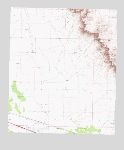
Myndus, NM USGS Topographic Map
Click on map above to begin viewing in our Map Viewer.

This topographic map contains these locations and features:
Feature Name Type Latitude Longitude GNIS ID View Map
01582 Water WellWellN32.3715°W107.4278°922418View Map
01588 Water WellWellN32.3329°W107.3925°930167View Map
01593 Water WellWellN32.3181°W107.4870°925451View Map
01594 Water WellWellN32.3298°W107.4714°922393View Map
01595 Water WellWellN32.3293°W107.4225°930165View Map
01596 Water WellWellN32.3031°W107.4334°922392View Map
01597 Water WellWellN32.3040°W107.4311°930171View Map
01599 Water WellWellN32.2931°W107.4045°930177View Map
01601 Water WellWellN32.2626°W107.4975°922420View Map
01602 Water WellWellN32.2715°W107.4567°925422View Map
01603 Water WellWellN32.2579°W107.4667°922419View Map
06112 Water WellWellN32.3506°W107.4767°925455View Map
06113 Water WellWellN32.3290°W107.4697°925454View Map
06114 Water WellWellN32.3001°W107.4181°925445View Map
06115 Water WellWellN32.2618°W107.4534°922391View Map
Coyote WellWellN32.3187°W107.4886°888038View Map
Fox WellWellN32.3031°W107.4331°889205View Map
Good Sight WellWellN32.3712°W107.4272°889500View Map
Lewis FlatsFlatN32.2754°W107.4934°891056View Map
Macho CreekStreamN32.2845°W107.4609°908331View Map
MyndusPopulated PlaceN32.2601°W107.4572°920653View Map
Myndus Post Office (historical)Post OfficeN32.2601°W107.4572°937291View Map
Number 1210 Water WellWellN32.3531°W107.4786°922417View Map
Pipe Tower WellWellN32.3309°W107.4245°893328View Map
Plain Mountain WellWellN32.3320°W107.3939°893350View Map
Plain WellWellN32.3301°W107.4714°893351View Map
Plank WellWellN32.2784°W107.4534°893353View Map
Salt WellWellN32.2920°W107.4047°894366View Map
Sand WellLocaleN32.2609°W107.3756°894531View Map
Simpson RanchLocaleN32.2704°W107.4550°894861View Map
Solo Ranch AirportAirportN32.2625°W107.4006°936940View Map
Steam Pump WellLocaleN32.3529°W107.4786°895321View Map

Note: Coordinates in the location and feature list above are referenced to NAD83 datum.


Copyright (C) 2008-2024 Ryan Niemi / Sunset Dynamics ... All Rights Reserved