TopoQuest Logo
Do you find TopoQuest useful?
Help keep TopoQuest running and adding new maps/features by donating!
Bitcoin:  19c7KJd3qBynnjoSw5npx9KScwjBe4ifkT
Litecoin:  LXs6TkuXGGXo1vDsWCkWVdjQX94eUKd6ui
Home View Maps Find Maps Find Places Resources & Links


Mount Morris, New York Topographic Map

USGS Map Title: Mount Morris, NY
USGS Map MRC: 42077F8
DRG (GeoTIFF) Download: o42077f8.tif


Neighboring USGS Topographic Map Quads:


  Wyoming, NY  
42078G1
 

  Leicester, NY  
42077G8
 

  Geneseo, NY  
42077G7
 

  Castile, NY  
42078F1
 

  Mount Morris, NY  
42077F8
 

  Sonyea, NY  
42077F7
 

  Portageville, NY  
42078E1
 

  Nunda, NY  
42077E8
 

  Ossian, NY  
42077E7


Map MRC Location:

N43°
W78°
N43°
W77°
H8 H7 H6 H5 H4 H3 H2 H1
G8 G7 G6 G5 G4 G3 G2 G1
F8 F7 F6 F5 F4 F3 F2 F1
E8 E7 E6 E5 E4 E3 E2 E1
D8 D7 D6 D5 D4 D3 D2 D1
C8 C7 C6 C5 C4 C3 C2 C1
B8 B7 B6 B5 B4 B3 B2 B1
A8 A7 A6 A5 A4 A3 A2 A1
N42°
W78°
N42°
W77°

Mount Morris, NY USGS 1:24K Topographic Map Preview:
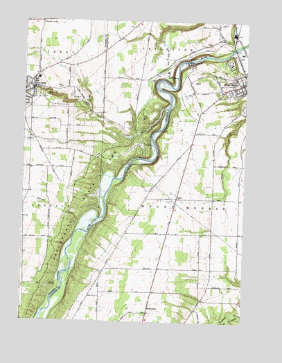
Mount Morris, NY USGS Topographic Map
Click on map above to begin viewing in our Map Viewer.

This topographic map contains these locations and features:
Feature Name Type Latitude Longitude GNIS ID View Map
Beau View FarmsLocaleN42.7094°W77.9989°2707195View Map
Brooks GrovePopulated PlaceN42.6306°W77.9281°944857View Map
Eastover BrookStreamN42.6678°W77.9575°949305View Map
Fitch FarmsLocaleN42.7008°W77.9781°2707188View Map
Five Corners (historical)LocaleN42.6397°W77.9983°2380870View Map
Gardeau Crest FarmLocaleN42.6819°W77.9983°2707180View Map
Gardeau OverlookParkN42.6401°W77.9833°950874View Map
Glenwood CemeteryCemeteryN42.7189°W77.9883°951243View Map
Highbanks CampgroundsLocaleN42.6976°W77.9319°952771View Map
Highbanks Recreation AreaParkN42.7276°W77.9197°952772View Map
Hope CemeteryCemeteryN42.7236°W77.9956°2400849View Map
Lacy CreekStreamN42.7120°W77.9625°954869View Map
Letchworth State ParkParkN42.6851°W77.9592°970286View Map
Mount Morris CemeteryCemeteryN42.7200°W77.8906°2547855View Map
Mount Morris DamDamN42.7334°W77.9067°979965View Map
Mount Morris Elementary - Middle SchoolSchoolN42.7129°W77.8754°2667601View Map
Mount Morris Hospital (historical)HospitalN42.7323°W77.8833°957863View Map
Mount Morris LakeReservoirN42.7334°W77.9067°979963View Map
Old Acres FarmLocaleN42.7339°W77.9650°2559228View Map
Old CemeteryCemeteryN42.7229°W77.8818°2547856View Map
Park View FarmsLocaleN42.7181°W77.9536°2707203View Map
Parkway Mobile Home ParkPopulated PlaceN42.7277°W77.9011°2598840View Map
Perry Elementary SchoolSchoolN42.7263°W77.9970°2668892View Map
Perry Middle SchoolSchoolN42.7269°W77.9969°2669180View Map
Perry Village Wastewater Treatment PlantLocaleN42.7206°W77.9843°2617746View Map
RidgePopulated PlaceN42.6762°W77.9133°962491View Map
River Road ForksLocaleN42.6433°W77.9553°2353114View Map
Riverview CemeteryCemeteryN42.6759°W77.9234°2547854View Map
Saint John's Episcopal ChurchChurchN42.7247°W77.8764°2597816View Map
Saint Patrick's CemeteryCemeteryN42.7198°W77.8824°2547857View Map
Saint Patricks Holy Angel Catholic ChurchChurchN42.7238°W77.8768°2597818View Map
Saint Stanislaus Kostka CemeteryCemeteryN42.7214°W77.9892°2400850View Map
Saint Stanislaus Roman Catholic ChurchChurchN42.7211°W77.9958°2400848View Map
Scott's Sky Ranch AirportAirportN42.6428°W77.9185°2443161View Map
Silver Lake OutletStreamN42.7140°W77.9189°965276View Map
Simmons CornersLocaleN42.7495°W77.9908°970610View Map
The Baptist Church of PerryChurchN42.7211°W77.9994°2400847View Map
Town of Mount MorrisCivilN42.6654°W77.9004°979243View Map
Tuscarora Plateau AirportAirportN42.6380°W77.8842°978338View Map
United Church of Mount MorrisChurchN42.7252°W77.8774°2597823View Map
Village of Mount MorrisCivilN42.7237°W77.8752°2391000View Map

Note: Coordinates in the location and feature list above are referenced to NAD83 datum.


Copyright (C) 2008-2024 Ryan Niemi / Sunset Dynamics ... All Rights Reserved