TopoQuest Logo
Do you find TopoQuest useful?
Help keep TopoQuest running and adding new maps/features by donating!
Bitcoin:  19c7KJd3qBynnjoSw5npx9KScwjBe4ifkT
Litecoin:  LXs6TkuXGGXo1vDsWCkWVdjQX94eUKd6ui
Home View Maps Find Maps Find Places Resources & Links


Aiken NW, South Carolina Topographic Map

USGS Map Title: Aiken NW, SC
USGS Map MRC: 33081F6
DRG (GeoTIFF) Download: o33081f6.tif


Neighboring USGS Topographic Map Quads:


  Johnston, SC  
33081G7
 

  Ridge Spring, SC  
33081G6
 

  Monetta, SC  
33081G5
 

  Trenton, SC  
33081F7
 

  Aiken NW, SC  
33081F6
 

  Foxtown, SC  
33081F5
 

  Graniteville, SC  
33081E7
 

  Aiken, SC  
33081E6
 

  Oakwood, SC  
33081E5


Map MRC Location:

N34°
W82°
N34°
W81°
H8 H7 H6 H5 H4 H3 H2 H1
G8 G7 G6 G5 G4 G3 G2 G1
F8 F7 F6 F5 F4 F3 F2 F1
E8 E7 E6 E5 E4 E3 E2 E1
D8 D7 D6 D5 D4 D3 D2 D1
C8 C7 C6 C5 C4 C3 C2 C1
B8 B7 B6 B5 B4 B3 B2 B1
A8 A7 A6 A5 A4 A3 A2 A1
N33°
W82°
N33°
W81°

Aiken NW, SC USGS 1:24K Topographic Map Preview:
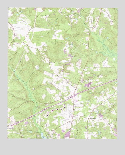
Aiken NW, SC USGS Topographic Map
Click on map above to begin viewing in our Map Viewer.

This topographic map contains these locations and features:
Feature Name Type Latitude Longitude GNIS ID View Map
Aiken Air Force Station (historical)MilitaryN33.6464°W81.6769°2086832View Map
Aiken Army Air Field (historical)MilitaryN33.6500°W81.6847°1985989View Map
Aiken Municipal AirportAirportN33.6498°W81.6789°1251840View Map
Aiken Northeast DivisionCivilN33.6571°W81.6491°1938257View Map
Aiken WaterworksLocaleN33.6543°W81.7157°1242356View Map
Airport ChurchChurchN33.6604°W81.6740°1220145View Map
Beaverdam Baptist ChurchChurchN33.6388°W81.6343°1245015View Map
Boggy BranchStreamN33.6671°W81.7243°1220854View Map
Bridge CreekStreamN33.7051°W81.6271°1220953View Map
Bridge Creek School (historical)SchoolN33.7049°W81.6934°1236251View Map
Brogdon BranchStreamN33.6446°W81.7198°1220985View Map
Camp NeKiaLocaleN33.6815°W81.7396°1221259View Map
Center Fire DepartmentBuildingN33.6590°W81.6749°2578568View Map
Center SchoolSchoolN33.6460°W81.6751°1247233View Map
Central ChurchChurchN33.6640°W81.6337°1221488View Map
Central School (historical)SchoolN33.6649°W81.6332°1236277View Map
Cumbee CemeteryCemeteryN33.7312°W81.6562°1221870View Map
Curry BranchStreamN33.6840°W81.7387°1221879View Map
Dairy BranchStreamN33.6388°W81.7168°1221912View Map
Fountain Academy (historical)SchoolN33.6343°W81.6582°1236333View Map
Givens Pond (historical)ReservoirN33.7040°W81.6590°1236344View Map
Gregory CemeteryCemeteryN33.7460°W81.6754°1222901View Map
Hicks BridgeBridgeN33.7440°W81.6748°1223149View Map
Hildridge Branch School (historical)SchoolN33.7354°W81.7201°1236371View Map
Holmes Long Branch Dam D-2047DamN33.7335°W81.7082°1239139View Map
Holmes Long Branch PondReservoirN33.7335°W81.7082°1239140View Map
Holmes PondReservoirN33.7456°W81.7354°1223252View Map
Holmes Pond Dam D-2026DamN33.7460°W81.7337°1239159View Map
Interchange 18CrossingN33.6390°W81.7407°1228139View Map
Interchange 22CrossingN33.6665°W81.6740°1228140View Map
Jumping Gut CreekStreamN33.7424°W81.6673°1223680View Map
Kalop BranchStreamN33.7254°W81.6523°1223691View Map
Lake JosephineLakeN33.7153°W81.6773°1223667View Map
Long BranchStreamN33.6301°W81.7115°1224117View Map
Long BranchStreamN33.7443°W81.6779°1224120View Map
Macedonia ChurchChurchN33.6296°W81.7026°1224245View Map
Mason BranchStreamN33.6768°W81.7293°1224363View Map
Melton BranchStreamN33.6949°W81.7490°1224450View Map
Mile BranchStreamN33.7274°W81.6562°1224490View Map
Mill BranchStreamN33.7035°W81.6626°1224503View Map
Morris LakeReservoirN33.7046°W81.6788°1238072View Map
Morris PondReservoirN33.6314°W81.7234°1224660View Map
Mount Pisgah CemeteryCemeteryN33.6354°W81.6590°1224762View Map
Mount Sinai Baptist ChurchChurchN33.7176°W81.7437°1249677View Map
Mount Zion School (historical)SchoolN33.7182°W81.7440°1236448View Map
Needham Brown CemeteryCemeteryN33.6351°W81.7482°1224943View Map
Nobles LakeReservoirN33.6316°W81.6454°1225063View Map
Pentecostal Holiness ChurchChurchN33.6504°W81.6746°1236473View Map
Plato School (historical)SchoolN33.7268°W81.7437°1236486View Map
Randall Branch Baptist ChurchChurchN33.6446°W81.6932°1250291View Map
Reedy ForkStreamN33.7032°W81.6746°1225820View Map
Reynolds PondReservoirN33.6285°W81.7132°1237940View Map
Round Branch Church (historical)ChurchN33.6510°W81.6887°1236504View Map
Scott CemeteryCemeteryN33.6285°W81.7137°1226455View Map
Seigler CemeteryCemeteryN33.6418°W81.6570°1226488View Map
Seigler CemeteryCemeteryN33.6471°W81.6632°1226489View Map
Seigler Family CemeteryCemeteryN33.6481°W81.6442°1226490View Map
Seiglers CrossroadsPopulated PlaceN33.6449°W81.6571°1226491View Map
Shiloh Baptist ChurchChurchN33.6576°W81.7057°1250861View Map
Shiloh Church (historical)ChurchN33.6288°W81.6990°1236534View Map
Shiloh School (historical)SchoolN33.6440°W81.6929°1236536View Map
South Carolina Noname 02002 D-0710 DamDamN33.6285°W81.7132°1237939View Map
South Carolina Noname 02039 DamDamN33.6251°W81.6698°1237996View Map
South Carolina Noname 02108 D-2045 DamDamN33.7051°W81.6765°1238071View Map
Timmerman CemeteryCemeteryN33.7307°W81.7398°1227147View Map

Note: Coordinates in the location and feature list above are referenced to NAD83 datum.


Copyright (C) 2008-2024 Ryan Niemi / Sunset Dynamics ... All Rights Reserved