TopoQuest Logo
Do you find TopoQuest useful?
Help keep TopoQuest running and adding new maps/features by donating!
Bitcoin:  19c7KJd3qBynnjoSw5npx9KScwjBe4ifkT
Litecoin:  LXs6TkuXGGXo1vDsWCkWVdjQX94eUKd6ui
Home View Maps Find Maps Find Places Resources & Links


Morgan Hill, California Topographic Map

USGS Map Title: Morgan Hill, CA
USGS Map MRC: 37121B6
DRG (GeoTIFF) Download: o37121b6.tif


Neighboring USGS Topographic Map Quads:


  San Jose East, CA  
37121C7
 

  Lick Observatory, CA  
37121C6
 

  Isabel Valley, CA  
37121C5
 

  Santa Teresa Hills, CA  
37121B7
 

  Morgan Hill, CA  
37121B6
 

  Mount Sizer, CA  
37121B5
 

  Loma Prieta, CA  
37121A7
 

  Mount Madonna, CA  
37121A6
 

  Gilroy, CA  
37121A5


Map MRC Location:

N38°
W122°
N38°
W121°
H8 H7 H6 H5 H4 H3 H2 H1
G8 G7 G6 G5 G4 G3 G2 G1
F8 F7 F6 F5 F4 F3 F2 F1
E8 E7 E6 E5 E4 E3 E2 E1
D8 D7 D6 D5 D4 D3 D2 D1
C8 C7 C6 C5 C4 C3 C2 C1
B8 B7 B6 B5 B4 B3 B2 B1
A8 A7 A6 A5 A4 A3 A2 A1
N37°
W122°
N37°
W121°

Morgan Hill, CA USGS 1:24K Topographic Map Preview:
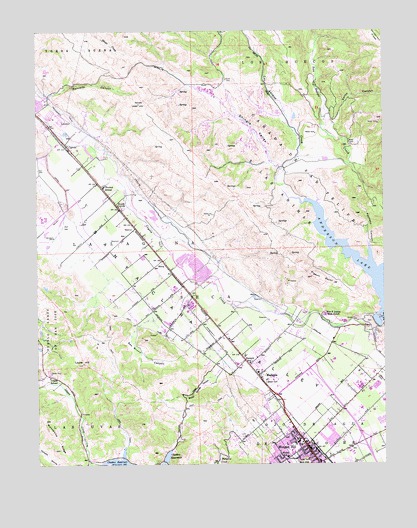
Morgan Hill, CA USGS Topographic Map
Click on map above to begin viewing in our Map Viewer.

This topographic map contains these locations and features:
Feature Name Type Latitude Longitude GNIS ID View Map
Advent Lutheran ChurchChurchN37.1319°W121.6272°1834892View Map
Anderson Lake County ParkParkN37.1774°W121.6272°1834917View Map
Ann Sobrato High SchoolSchoolN37.1594°W121.6701°2518196View Map
Britton FieldParkN37.1297°W121.6588°1834953View Map
Burnett Elementary School (historical)SchoolN37.1542°W121.6791°1834957View Map
Burnett SchoolSchoolN37.1544°W121.6752°220198View Map
Caņada De San Felipe Y Las AnimasCivilN37.2052°W121.6555°233628View Map
Carlin CanyonValleyN37.2233°W121.6441°220599View Map
Central High SchoolSchoolN37.1362°W121.6587°1834979View Map
Charter School of Morgan HillSchoolN37.2051°W121.7268°223209View Map
Church of the Rock Morgan Hill Foursquare ChurchChurchN37.1286°W121.6613°1835004View Map
City of Morgan HillCivilN37.1324°W121.6410°2411162View Map
Cochrane Plaza Shopping CenterLocaleN37.1511°W121.6558°1835008View Map
CoyotePopulated PlaceN37.2166°W121.7405°252656View Map
Coyote Post OfficePost OfficeN37.2164°W121.7387°1835017View Map
Crossroads Christian SchoolSchoolN37.1338°W121.6615°2518291View Map
Del Monte ParkParkN37.1352°W121.6611°1835022View Map
El Toro Elementary SchoolSchoolN37.1352°W121.6490°1835033View Map
Emilio Guglielmo WineryLocaleN37.1463°W121.6313°1835034View Map
Exit 366CrossingN37.1317°W121.6336°2123299View Map
Exit 367CrossingN37.1531°W121.6522°2123300View Map
Field Sports County ParkParkN37.2194°W121.7272°1835044View Map
First Assembly of God ChurchChurchN37.1344°W121.6599°1835046View Map
First Baptist ChurchChurchN37.1272°W121.6608°1835047View Map
Galvan ParkParkN37.1297°W121.6602°1835073View Map
Henderson RidgeRidgeN37.2474°W121.6266°225167View Map
Interdenominational Church of Morgan HillChurchN37.1280°W121.6608°1835126View Map
KAZA-AM (Gilroy)TowerN37.1633°W121.6422°1662625View Map
La Laguna SecaCivilN37.1916°W121.7008°226711View Map
Las Animas CreekStreamN37.2038°W121.6627°226891View Map
Las UvasCivilN37.1372°W121.7236°234140View Map
Laurel HillSummitN37.1538°W121.7347°226946View Map
Leroy Anderson 72-009 DamDamN37.1655°W121.6294°1663527View Map
Lewis H Britton Middle SchoolSchoolN37.1314°W121.6573°1835152View Map
Live Oak High SchoolSchoolN37.1469°W121.6345°1835155View Map
Llagas SchoolSchoolN37.1499°W121.7469°227437View Map
MadronePopulated PlaceN37.1505°W121.6716°1659034View Map
Manzanita RidgeRidgeN37.1374°W121.7488°234240View Map
Metcalfe CanyonValleyN37.2313°W121.7469°228544View Map
Morgan HillPopulated PlaceN37.1305°W121.6544°1659174View Map
Morgan Hill Asembly of God ChurchChurchN37.1333°W121.6611°1835210View Map
Morgan Hill Branch Santa Clara County Free LibraryBuildingN37.1252°W121.6624°1835211View Map
Morgan Hill HouseBuildingN37.1355°W121.6577°1835214View Map
Morgan Hill MuseumBuildingN37.1252°W121.6630°1835215View Map
Motorcycle County ParkParkN37.2349°W121.7102°1835218View Map
Murphy Springs ParkParkN37.1411°W121.6716°1835235View Map
Nob Hill Shopping CenterLocaleN37.1286°W121.6597°1835242View Map
Nordstrom Elementary SchoolSchoolN37.1350°W121.6270°1835244View Map
Ojo De Agua De La CocheCivilN37.1316°W121.6388°234406View Map
P A Walsh Elementary SchoolSchoolN37.1272°W121.6613°237210View Map
Pacheco CanyonValleyN37.1833°W121.6302°230191View Map
PerryPopulated PlaceN37.1836°W121.7063°252763View Map
Pigeon PointCapeN37.1799°W121.6530°230644View Map
Riverside Golf CourseLocaleN37.1897°W121.7483°1835296View Map
Saint Catherine's SchoolSchoolN37.1257°W121.6606°1835308View Map
Saint Louise Health Center (historical)HospitalN37.1527°W121.6483°1835312View Map
San Bruno CanyonValleyN37.1649°W121.7155°232379View Map
San Felipe CreekStreamN37.2133°W121.6566°234625View Map
Santa Clara CountyCivilN37.2325°W121.6963°277307View Map
Santa Clara County Fire Department El Toro Fire StationBuildingN37.1414°W121.6631°2624214View Map
Shingle ValleyValleyN37.2108°W121.6641°233022View Map
South CoyotePopulated PlaceN37.1988°W121.7216°252803View Map
The Church of Jesus Christ of Latter Day SaintsChurchN37.1352°W121.6266°1834999View Map
United Technology Corporation Fire DepartmentBuildingN37.2339°W121.6936°2624248View Map
Valley Baptist ChurchChurchN37.1391°W121.6666°1835429View Map
William F James Boys RanchLocaleN37.1683°W121.6474°238084View Map
Willow Springs CanyonValleyN37.1536°W121.6852°237950View Map

Note: Coordinates in the location and feature list above are referenced to NAD83 datum.


Copyright (C) 2008-2024 Ryan Niemi / Sunset Dynamics ... All Rights Reserved