TopoQuest Logo
Do you find TopoQuest useful?
Help keep TopoQuest running and adding new maps/features by donating!
Bitcoin:  19c7KJd3qBynnjoSw5npx9KScwjBe4ifkT
Litecoin:  LXs6TkuXGGXo1vDsWCkWVdjQX94eUKd6ui
Home View Maps Find Maps Find Places Resources & Links


Montoya Butte, New Mexico Topographic Map

USGS Map Title: Montoya Butte, NM
USGS Map MRC: 33107E5
DRG (GeoTIFF) Download: o33107e5.tif


Neighboring USGS Topographic Map Quads:


  Dusty, NM  
33107F6
 

  Welty Hill, NM  
33107F5
 

  Blue Mountain, NM  
33107F4
 

  Wahoo Ranch, NM  
33107E6
 

  Montoya Butte, NM  
33107E5
 

  Vicks Peak, NM  
33107E4
 

  Iron Mountain, NM  
33107D6
 

  Jaralosa Mountain, NM  
33107D5
 

  Monticello, NM  
33107D4


Map MRC Location:

N34°
W108°
N34°
W107°
H8 H7 H6 H5 H4 H3 H2 H1
G8 G7 G6 G5 G4 G3 G2 G1
F8 F7 F6 F5 F4 F3 F2 F1
E8 E7 E6 E5 E4 E3 E2 E1
D8 D7 D6 D5 D4 D3 D2 D1
C8 C7 C6 C5 C4 C3 C2 C1
B8 B7 B6 B5 B4 B3 B2 B1
A8 A7 A6 A5 A4 A3 A2 A1
N33°
W108°
N33°
W107°

Montoya Butte, NM USGS 1:24K Topographic Map Preview:
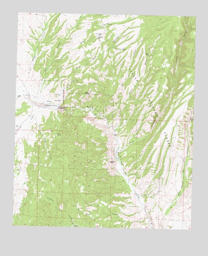
Montoya Butte, NM USGS Topographic Map
Click on map above to begin viewing in our Map Viewer.

This topographic map contains these locations and features:
Feature Name Type Latitude Longitude GNIS ID View Map
Allison WellWellN33.5431°W107.6023°903111View Map
Alum SpringSpringN33.5541°W107.5958°903122View Map
Bar A CanyonValleyN33.5642°W107.5631°903546View Map
Bar A TankReservoirN33.5943°W107.5435°1991049View Map
Bennie Mil Water WellWellN33.5267°W107.6050°925796View Map
Black MountainSummitN33.5784°W107.5770°903882View Map
Bobtail CanyonValleyN33.5576°W107.5556°903980View Map
Bobtail TankReservoirN33.6023°W107.5327°903982View Map
Boulder TankReservoirN33.6046°W107.5520°904025View Map
Cherryville (historical)Populated PlaceN33.5695°W107.6050°920541View Map
Deep Water WellWellN33.6192°W107.5625°925600View Map
Deep WellWellN33.6192°W107.5614°905673View Map
Drift Fence TankReservoirN33.5882°W107.5030°913736View Map
Eds WindmillLocaleN33.5453°W107.5042°913743View Map
Elk TankReservoirN33.5941°W107.5240°913735View Map
Flat TankReservoirN33.5623°W107.5128°913737View Map
Kelly CanyonValleyN33.5445°W107.5531°907524View Map
Knisely CanyonValleyN33.5767°W107.6203°907579View Map
Lower WindmillLocaleN33.5070°W107.5189°913745View Map
Mike Springs CanyonValleyN33.5653°W107.6128°908733View Map
Monticello BoxGapN33.5695°W107.5934°908853View Map
Montoya ButteSummitN33.5387°W107.5581°908860View Map
Ojo CalienteSpringN33.5738°W107.5938°909310View Map
Ojo CalienteSpringN33.5320°W107.5937°902637View Map
Ojo Caliente Military Post Historic SiteLocaleN33.5320°W107.5937°934407View Map
Ojo Caliente SpringMineN33.5709°W107.6034°917421View Map
Park TankReservoirN33.5801°W107.5262°937074View Map
Pine CanyonValleyN33.5859°W107.6064°909658View Map
Post CanyonValleyN33.5851°W107.6059°909804View Map
Prairie Dog TankReservoirN33.6133°W107.5666°909840View Map
Puppy Dog TankReservoirN33.6113°W107.5694°909904View Map
Rattlesnake WellWellN33.5326°W107.6206°925799View Map
Sam Hill CanyonValleyN33.5067°W107.5314°910584View Map
Sim Yaten CanyonValleyN33.5745°W107.6164°911082View Map
Spring CanyonValleyN33.5706°W107.5956°911317View Map
Spring Canyon WellWellN33.5770°W107.5939°911328View Map
Steel WindmillLocaleN33.5309°W107.5073°913744View Map
TaylorMineN33.5412°W107.5834°917911View Map
Upper CorralLocaleN33.5573°W107.5042°913742View Map
Warm Springs Apache Reservation (historical)CivilN33.5737°W107.5934°920359View Map
Whitetail CanyonValleyN33.5645°W107.5034°912337View Map
Wild Bull CanyonValleyN33.5715°W107.6056°912367View Map
Wildhorse CanyonValleyN33.5703°W107.6081°912386View Map

Note: Coordinates in the location and feature list above are referenced to NAD83 datum.


Copyright (C) 2008-2024 Ryan Niemi / Sunset Dynamics ... All Rights Reserved