TopoQuest Logo
Do you find TopoQuest useful?
Help keep TopoQuest running and adding new maps/features by donating!
Bitcoin:  19c7KJd3qBynnjoSw5npx9KScwjBe4ifkT
Litecoin:  LXs6TkuXGGXo1vDsWCkWVdjQX94eUKd6ui
Home View Maps Find Maps Find Places Resources & Links


Montoursville North, Pennsylvania Topographic Map

USGS Map Title: Montoursville North, PA
USGS Map MRC: 41076C8
DRG (GeoTIFF) Download: o41076c8.tif


Neighboring USGS Topographic Map Quads:


  Trout Run, PA  
41077D1
 

  Bodines, PA  
41076D8
 

  Barbours, PA  
41076D7
 

  Cogan Station, PA  
41077C1
 

  Montoursville North, PA  
41076C8
 

  Huntersville, PA  
41076C7
 

  Williamsport, PA  
41077B1
 

  Montoursville South, PA  
41076B8
 

  Muncy, PA  
41076B7


Map MRC Location:

N42°
W77°
N42°
W76°
H8 H7 H6 H5 H4 H3 H2 H1
G8 G7 G6 G5 G4 G3 G2 G1
F8 F7 F6 F5 F4 F3 F2 F1
E8 E7 E6 E5 E4 E3 E2 E1
D8 D7 D6 D5 D4 D3 D2 D1
C8 C7 C6 C5 C4 C3 C2 C1
B8 B7 B6 B5 B4 B3 B2 B1
A8 A7 A6 A5 A4 A3 A2 A1
N41°
W77°
N41°
W76°

Montoursville North, PA USGS 1:24K Topographic Map Preview:
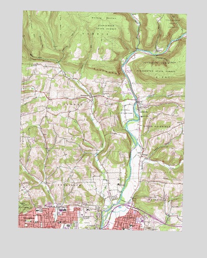
Montoursville North, PA USGS Topographic Map
Click on map above to begin viewing in our Map Viewer.

This topographic map contains these locations and features:
Feature Name Type Latitude Longitude GNIS ID View Map
Butternut GrovePopulated PlaceN41.3540°W76.8975°1205031View Map
Butternut Grove RunStreamN41.3517°W76.8977°1192225View Map
Calebs RunStreamN41.3348°W76.9564°1192227View Map
Christian Hill CemeteryCemeteryN41.3281°W76.9375°1192263View Map
Crooked Riffles HollowValleyN41.3509°W76.8984°1192315View Map
Divine Providence HospitalHospitalN41.2599°W76.9846°1192362View Map
Dry RunStreamN41.3629°W76.8777°1192375View Map
Edgewood CemeteryCemeteryN41.2504°W76.9427°1192418View Map
Edgewood CemeteryCemeteryN41.2503°W76.9422°1174014View Map
Eldred Township Volunteer Fire CompanyBuildingN41.3205°W76.9451°2652684View Map
Emmanuel ChurchChurchN41.2626°W76.9669°1192433View Map
FarragutPopulated PlaceN41.2931°W76.9066°1192449View Map
Faxon Census Designated PlaceCensusN41.2557°W76.9771°2629318View Map
Fourmile SchoolSchoolN41.2612°W76.9469°1192484View Map
Greens HollowValleyN41.2916°W76.9016°1192556View Map
Hecht SchoolSchoolN41.2537°W76.9669°1192598View Map
Jacoby HollowValleyN41.3746°W76.9134°1192684View Map
Kaiser HollowValleyN41.3205°W76.9079°1192703View Map
KenmarPopulated PlaceN41.2534°W76.9594°1192706View Map
Kenmar Census Designated PlaceCensusN41.2547°W76.9550°2629319View Map
Lick RunStreamN41.2940°W76.9391°1192776View Map
Loyalsock State Game FarmParkN41.3181°W76.9200°1192859View Map
Loyalsock Valley SchoolSchoolN41.3156°W76.9077°1192860View Map
Loyalsock Volunteer Fire CompanyBuildingN41.2519°W76.9722°2652839View Map
LoyalsockvillePopulated PlaceN41.3209°W76.9094°1192858View Map
Lysock-View County HomeBuildingN41.2759°W76.9236°1192867View Map
Lyter SchoolSchoolN41.2526°W76.9136°1192868View Map
Martins RunStreamN41.3476°W76.9858°1192900View Map
Mill CreekStreamN41.2551°W76.9344°1192936View Map
Mill CreekStreamN41.2612°W76.9336°1199907View Map
Mill Creek ChurchChurchN41.2784°W76.9316°1192939View Map
Mill Creek MountainSummitN41.3665°W76.9939°1192940View Map
MontoursvillePopulated PlaceN41.2542°W76.9205°1213650View Map
Montoursville Borough Police DepartmentBuildingN41.2579°W76.9220°2780517View Map
Mount Zion ChurchChurchN41.3120°W76.8761°1192973View Map
North EldredPopulated PlaceN41.3426°W76.9705°1197441View Map
Northway ChurchChurchN41.2579°W76.9683°1193051View Map
Ohey Sholem CemeteryCemeteryN41.2521°W76.9424°1193061View Map
Penn ValePopulated PlaceN41.2584°W76.9630°1196539View Map
Pilgrim ChurchChurchN41.2504°W76.9841°1193122View Map
Quaker HillSummitN41.3184°W76.9808°1197443View Map
Quaker Hill CemeteryCemeteryN41.3192°W76.9794°1193165View Map
Red Bank TrailTrailN41.3384°W76.8897°1206307View Map
Riffle TrailTrailN41.3473°W76.8864°1206306View Map
Saint Anns ChurchChurchN41.2542°W76.9711°1193244View Map
Saint Boniface CemeteryCemeteryN41.2517°W76.9936°1193246View Map
School for Mentally RetardedSchoolN41.2573°W76.9822°1193298View Map
Scofield MountainSummitN41.3465°W76.9861°1193303View Map
Shafer Memorial GroundsLocaleN41.3434°W76.9919°1193321View Map
Sheridan SchoolSchoolN41.2537°W76.9861°1193342View Map
State Game Lands Number 298ParkN41.3667°W76.9664°1208377View Map
Sugarcamp RunStreamN41.3456°W76.9716°1193497View Map
The Wells MountainSummitN41.3726°W76.9725°1193528View Map
Township of EldredCivilN41.3208°W76.9566°1216747View Map
Township of LoyalsockCivilN41.2742°W76.9840°1216755View Map
Wallis RunStreamN41.3540°W76.9116°1199736View Map
WarrensvillePopulated PlaceN41.3265°W76.9455°1193611View Map

Note: Coordinates in the location and feature list above are referenced to NAD83 datum.


Copyright (C) 2008-2024 Ryan Niemi / Sunset Dynamics ... All Rights Reserved