TopoQuest Logo
Do you find TopoQuest useful?
Help keep TopoQuest running and adding new maps/features by donating!
Bitcoin:  19c7KJd3qBynnjoSw5npx9KScwjBe4ifkT
Litecoin:  LXs6TkuXGGXo1vDsWCkWVdjQX94eUKd6ui
Home View Maps Find Maps Find Places Resources & Links


Monero, New Mexico Topographic Map

USGS Map Title: Monero, NM
USGS Map MRC: 36106H7
DRG (GeoTIFF) Download: o36106h7.tif


Neighboring USGS Topographic Map Quads:


  Edith, CO  
37106A8
 

  Chromo, CO  
37106A7
 

  Chama Peak, CO  
37106A6
 

  Dulce, NM  
36106H8
 

  Monero, NM  
36106H7
 

  Chromo Mountain, NM  
36106H6
 

  Cordova Canyon, NM  
36106G8
 

  Horse Lake, NM  
36106G7
 

  Sawmill Mesa, NM  
36106G6


Map MRC Location:

N37°
W107°
N37°
W106°
H8 H7 H6 H5 H4 H3 H2 H1
G8 G7 G6 G5 G4 G3 G2 G1
F8 F7 F6 F5 F4 F3 F2 F1
E8 E7 E6 E5 E4 E3 E2 E1
D8 D7 D6 D5 D4 D3 D2 D1
C8 C7 C6 C5 C4 C3 C2 C1
B8 B7 B6 B5 B4 B3 B2 B1
A8 A7 A6 A5 A4 A3 A2 A1
N36°
W107°
N36°
W106°

Monero, NM USGS 1:24K Topographic Map Preview:
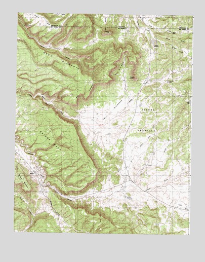
Monero, NM USGS Topographic Map
Click on map above to begin viewing in our Map Viewer.

This topographic map contains these locations and features:
Feature Name Type Latitude Longitude GNIS ID View Map
Abeyta RanchLocaleN36.9803°W106.8448°885536View Map
Barney Quaranto MineMineN36.9108°W106.8617°917086View Map
Biggs (historical)Populated PlaceN36.9056°W106.7923°901701View Map
Boyer GulchValleyN36.9047°W106.7898°886690View Map
Boyer LakeReservoirN36.9510°W106.7512°900110View Map
Briggs MesaSummitN36.9178°W106.8209°899551View Map
Caranta LeaseMineN36.8914°W106.8353°916906View Map
Caranta MineMineN36.9036°W106.8636°917058View Map
Caranta MineMineN36.8895°W106.8467°917059View Map
Caranta MinesMineN36.9092°W106.8528°917060View Map
Caranti Brothers MineMineN36.9028°W106.8648°887193View Map
Crowley Irrigation System DamDamN36.9850°W106.7789°924110View Map
Crowley PeakSummitN36.9900°W106.8095°900106View Map
Crowley ReservoirReservoirN36.9846°W106.7784°900107View Map
Diamante (historical)Populated PlaceN36.9325°W106.8170°901611View Map
Eagle PointSummitN36.9642°W106.7911°888616View Map
Early MineMineN36.8770°W106.8703°888632View Map
Gonzales RanchLocaleN36.9242°W106.7770°889485View Map
Martinez ProspectMineN36.9233°W106.8720°917003View Map
Mc Elroy Brothers MineMineN36.8981°W106.8692°917084View Map
McBroom MineMineN36.8947°W106.8495°917006View Map
Mesa DiamanteSummitN36.9608°W106.8192°898023View Map
Miller CanyonValleyN36.8839°W106.8606°900111View Map
MoneroPopulated PlaceN36.9020°W106.8553°892151View Map
Monero CanyonValleyN36.8970°W106.8545°900136View Map
Monero MountainSummitN36.8997°W106.8634°897559View Map
Monero Post Office (historical)Post OfficeN36.9020°W106.8553°938198View Map
North Boyer GulchValleyN36.9097°W106.7864°892558View Map
Prince RanchLocaleN36.9317°W106.8223°893490View Map
Rancho DiamanteLocaleN36.9325°W106.8170°893655View Map
Reed EscarpmentCliffN36.9536°W106.8223°893844View Map
Rincon de la AguilaValleyN36.9650°W106.8103°1945986View Map
Rock Creek MesaSummitN36.9967°W106.7531°910367View Map
San Luis MineMineN36.9028°W106.8581°917065View Map
Sczerbiak ProspectMineN36.9325°W106.8700°917067View Map
Stove TankReservoirN36.9901°W106.7650°900108View Map
Tecolote LakeReservoirN36.9620°W106.7673°900109View Map
Tomacino MineMineN36.9100°W106.8584°917075View Map
TorresLocaleN36.9583°W106.8381°924840View Map
Torrez RanchLocaleN36.9400°W106.8292°895770View Map
Valle DiamanteBasinN36.9425°W106.8028°898195View Map
Western Fuel Company MineMineN36.9000°W106.8673°917005View Map

Note: Coordinates in the location and feature list above are referenced to NAD83 datum.


Copyright (C) 2008-2024 Ryan Niemi / Sunset Dynamics ... All Rights Reserved