TopoQuest Logo
Do you find TopoQuest useful?
Help keep TopoQuest running and adding new maps/features by donating!
Bitcoin:  19c7KJd3qBynnjoSw5npx9KScwjBe4ifkT
Litecoin:  LXs6TkuXGGXo1vDsWCkWVdjQX94eUKd6ui
Home View Maps Find Maps Find Places Resources & Links


Milton, West Virginia Topographic Map

USGS Map Title: Milton, WV
USGS Map MRC: 38082D2
DRG (GeoTIFF) Download: o38082d2.tif


Neighboring USGS Topographic Map Quads:


  Athalia, OH  
38082E3
 

  Glenwood, WV  
38082E2
 

  Mount Olive, WV  
38082E1
 

  Barboursville, WV  
38082D3
 

  Milton, WV  
38082D2
 

  Hurricane, WV  
38082D1
 

  Winslow, WV  
38082C3
 

  West Hamlin, WV  
38082C2
 

  Hamlin, WV  
38082C1


Map MRC Location:

N39°
W83°
N39°
W82°
H8 H7 H6 H5 H4 H3 H2 H1
G8 G7 G6 G5 G4 G3 G2 G1
F8 F7 F6 F5 F4 F3 F2 F1
E8 E7 E6 E5 E4 E3 E2 E1
D8 D7 D6 D5 D4 D3 D2 D1
C8 C7 C6 C5 C4 C3 C2 C1
B8 B7 B6 B5 B4 B3 B2 B1
A8 A7 A6 A5 A4 A3 A2 A1
N38°
W83°
N38°
W82°

Milton, WV USGS 1:24K Topographic Map Preview:
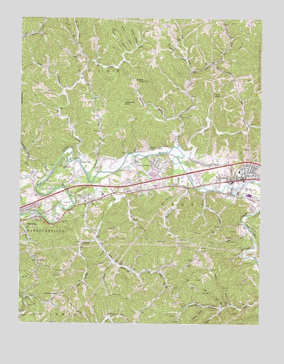
Milton, WV USGS Topographic Map
Click on map above to begin viewing in our Map Viewer.

This topographic map contains these locations and features:
Feature Name Type Latitude Longitude GNIS ID View Map
Alum ForkStreamN38.3806°W82.1446°1534907View Map
Antioch ChurchChurchN38.4081°W82.2174°1534975View Map
Arthur CemeteryCemeteryN38.4842°W82.2201°1535028View Map
Bayles HollowValleyN38.4890°W82.1893°1535320View Map
Bethel ChurchChurchN38.3790°W82.2029°1535695View Map
Bethesda United Methodist ChurchChurchN38.4298°W82.1943°1535725View Map
Beulah Ann ChurchChurchN38.4537°W82.2085°1535737View Map
Beulah ChapelChurchN38.4176°W82.1910°1535738View Map
Big Cabell CreekStreamN38.4418°W82.2182°1535813View Map
Big Hill HollowValleyN38.4829°W82.2157°1535849View Map
Blenko BridgeBridgeN38.4322°W82.1334°2635358View Map
Blue SulphurPopulated PlaceN38.4154°W82.2482°1553938View Map
Blue Sulphur Burial ParkCemeteryN38.4173°W82.2421°1536135View Map
Brush CreekStreamN38.4134°W82.1304°1536462View Map
Bryan ChapelChurchN38.4918°W82.1693°1536526View Map
Cabell CountyCivilN38.4203°W82.2417°1550012View Map
Cabell County Emergency Medical Services Station 1BuildingN38.4271°W82.2051°2581075View Map
Cabell County Sheriff's OfficeBuildingN38.4275°W82.2145°2727893View Map
Cabell Midland High SchoolSchoolN38.4285°W82.2078°2088149View Map
Camp ArrowheadLocaleN38.4398°W82.2363°1536887View Map
Camp GuyandotteLocaleN38.4401°W82.2265°1536930View Map
Chapman Family CemeteryCemeteryN38.4018°W82.1577°2586322View Map
Cow HollowValleyN38.4690°W82.2285°1537741View Map
Cyrus Creek ChurchChurchN38.4006°W82.2407°1537958View Map
District 5CivilN38.4594°W82.1844°1928241View Map
Dry CreekStreamN38.4301°W82.1565°1538348View Map
Edmonds BranchStreamN38.4365°W82.2146°1538560View Map
Fallen ForkStreamN38.3826°W82.1401°1538854View Map
First United Methodist ChurchChurchN38.4356°W82.1332°1740547View Map
Forest Memorial ParkCemeteryN38.4284°W82.1843°1539127View Map
Fudges CreekPopulated PlaceN38.4068°W82.2065°1549538View Map
Fudges CreekStreamN38.4354°W82.2101°1539294View Map
George Adam Floding BridgeBridgeN38.4189°W82.2378°2635352View Map
Gobbler KnobSummitN38.4745°W82.1857°1539482View Map
Grindstone HollowValleyN38.4837°W82.1643°1539757View Map
Hannah HollowValleyN38.4876°W82.1918°1539917View Map
Hatfield Lake DamDamN38.3834°W82.2232°1557416View Map
Hebron ChurchChurchN38.3781°W82.2493°1540113View Map
Horsebone GapGapN38.3873°W82.2285°1540499View Map
Howells MillPopulated PlaceN38.4418°W82.2196°1554750View Map
Huddleston KnobSummitN38.4656°W82.1960°1554753View Map
Indian MeadowsPopulated PlaceN38.4223°W82.2451°1740570View Map
Johns BranchStreamN38.4329°W82.1254°1540962View Map
Kiwanivista ParkParkN38.4168°W82.2290°1541258View Map
Lakeview Fishing Lake DamDamN38.3901°W82.2499°1557415View Map
Left Fork Lower CreekStreamN38.4784°W82.1607°1541685View Map
Little Cabell CreekStreamN38.4337°W82.2360°1542050View Map
Little Fudges CreekStreamN38.4090°W82.2101°1542105View Map
Long BranchStreamN38.4562°W82.1315°1542354View Map
Love CemeteryCemeteryN38.4259°W82.2126°1740579View Map
Lower CreekStreamN38.4473°W82.1679°1542532View Map
Lower Creek ChurchChurchN38.4598°W82.1676°1542534View Map
Malcolm Springs HeightsPopulated PlaceN38.4379°W82.1790°1740582View Map
Maupin CemeteryCemeteryN38.4342°W82.1926°1542884View Map
McComas BranchStreamN38.4595°W82.1679°1542950View Map
Mill CreekStreamN38.4445°W82.1646°1543323View Map
MiltonPopulated PlaceN38.4345°W82.1324°1543433View Map
Milton Baptist ChurchChurchN38.4356°W82.1349°1740588View Map
Milton Branch Cabell County Public LibraryBuildingN38.4362°W82.1332°1740589View Map
Milton CemeteryCemeteryN38.4367°W82.1267°2586202View Map
Milton Elementary SchoolSchoolN38.4374°W82.1358°1740590View Map
Milton High School (historical)SchoolN38.4329°W82.1396°1740591View Map
Milton Middle SchoolSchoolN38.4377°W82.1511°2088271View Map
Milton Police DepartmentBuildingN38.4365°W82.1325°2727894View Map
Milton Post OfficePost OfficeN38.4345°W82.1360°1740592View Map
Milton Volunteer Fire Department Station 1BuildingN38.4351°W82.1297°2578037View Map
Mount Zion ChurchChurchN38.4268°W82.2157°1543822View Map
Mud River Baptist ChurchChurchN38.4179°W82.2399°1740595View Map
Mud River CemeteryCemeteryN38.4176°W82.2399°1740596View Map
Mud River Covered BridgeBridgeN38.4309°W82.1396°1740597View Map
Mud River CSX OverpassBridgeN38.4365°W82.1632°2635366View Map
OnaPopulated PlaceN38.4248°W82.2132°1544405View Map
Ona AirparkAirportN38.4409°W82.2008°1558817View Map
Ona Elementary SchoolSchoolN38.4250°W82.2157°1740601View Map
Ona Industrial ParkLocaleN38.4254°W82.1940°1740602View Map
Ona Middle School (historical)SchoolN38.4279°W82.2068°1740603View Map
Ona Post OfficePost OfficeN38.4247°W82.2122°1740604View Map
Ona Volunteer Fire DepartmentBuildingN38.4267°W82.2157°2577862View Map
Perry Morris SquareLocaleN38.4356°W82.1309°2647118View Map
Pleasant Valley ChurchChurchN38.3968°W82.1907°1545024View Map
Poore HillSummitN38.4273°W82.2143°1740613View Map
Pressley Ridge School at Grant GardensSchoolN38.4340°W82.2034°2088321View Map
Rich KnobSummitN38.4684°W82.1463°1555472View Map
Right Fork Lower CreekStreamN38.4784°W82.1607°1545673View Map
Rolling HillsPopulated PlaceN38.4329°W82.1929°1740617View Map
Rush HollowValleyN38.4709°W82.2282°1546165View Map
Sang ForkStreamN38.3815°W82.1435°1546421View Map
Saunders CreekStreamN38.4409°W82.1674°1546454View Map
Sunrise TempleChurchN38.4470°W82.1826°1547761View Map
Tarkiln HollowValleyN38.3806°W82.1540°1547907View Map
Tin BridgeBridgeN38.4311°W82.1590°2635360View Map
Tony BranchStreamN38.4815°W82.1501°1548169View Map
Town of MiltonCivilN38.4354°W82.1376°2391307View Map
Warner ChurchChurchN38.4929°W82.2485°1548804View Map
Waugh BranchStreamN38.3995°W82.2018°1548842View Map
Waugh CemeteryCemeteryN38.3870°W82.2018°1548843View Map
Webb HollowValleyN38.4870°W82.1954°1548869View Map
WEMM-FM (Huntington)TowerN38.4759°W82.2499°1559795View Map
William Bradley Fulks Memorial BridgeBridgeN38.4436°W82.1900°2635354View Map
Wire BranchStreamN38.4262°W82.2001°1549253View Map
WPBY-TV (Huntington)TowerN38.4951°W82.2007°1559867View Map
WVWV-FM (Huntington)TowerN38.4951°W82.2007°1559794View Map
Yates CrossingPopulated PlaceN38.4415°W82.1899°1549445View Map

Note: Coordinates in the location and feature list above are referenced to NAD83 datum.


Copyright (C) 2008-2024 Ryan Niemi / Sunset Dynamics ... All Rights Reserved