TopoQuest Logo
Do you find TopoQuest useful?
Help keep TopoQuest running and adding new maps/features by donating!
Bitcoin:  19c7KJd3qBynnjoSw5npx9KScwjBe4ifkT
Litecoin:  LXs6TkuXGGXo1vDsWCkWVdjQX94eUKd6ui
Home View Maps Find Maps Find Places Resources & Links


Miami Station, Missouri Topographic Map

USGS Map Title: Miami Station, MO
USGS Map MRC: 39093C3
DRG (GeoTIFF) Download: o39093c3.tif


Neighboring USGS Topographic Map Quads:


  Standish, MO  
39093D4
 

  Bosworth, MO  
39093D3
 

  Brunswick West, MO  
39093D2
 

  Carrollton East, MO  
39093C4
 

  Miami Station, MO  
39093C3
 

  Miami, MO  
39093C2
 

  Grand Pass, MO  
39093B4
 

  Malta Bend, MO  
39093B3
 

  Marshall North, MO  
39093B2


Map MRC Location:

N40°
W94°
N40°
W93°
H8 H7 H6 H5 H4 H3 H2 H1
G8 G7 G6 G5 G4 G3 G2 G1
F8 F7 F6 F5 F4 F3 F2 F1
E8 E7 E6 E5 E4 E3 E2 E1
D8 D7 D6 D5 D4 D3 D2 D1
C8 C7 C6 C5 C4 C3 C2 C1
B8 B7 B6 B5 B4 B3 B2 B1
A8 A7 A6 A5 A4 A3 A2 A1
N39°
W94°
N39°
W93°

Miami Station, MO USGS 1:24K Topographic Map Preview:
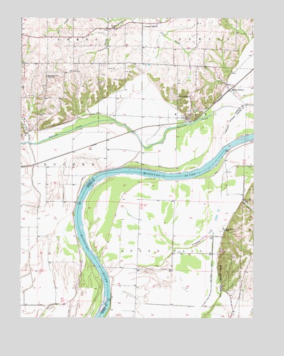
Miami Station, MO USGS Topographic Map
Click on map above to begin viewing in our Map Viewer.

This topographic map contains these locations and features:
Feature Name Type Latitude Longitude GNIS ID View Map
Adkins CemeteryCemeteryN39.3503°W93.3613°713155View Map
Bethlehem ChurchChurchN39.3509°W93.3616°714103View Map
Camp CreekStreamN39.3234°W93.3716°715260View Map
Cannon CemeteryCemeteryN39.3539°W93.3291°715367View Map
Coon HollowValleyN39.2992°W93.2558°716268View Map
Elder CemeteryCemeteryN39.3528°W93.3199°717433View Map
Elderbloom School (historical)SchoolN39.2989°W93.3552°746991View Map
Grand Pass Conservation AreaParkN39.2950°W93.3197°2093243View Map
Gray School (historical)SchoolN39.3420°W93.3608°746990View Map
Green Bud School (historical)SchoolN39.3422°W93.3280°746989View Map
Lake WooldridgeReservoirN39.2815°W93.2610°761274View Map
LetaPopulated PlaceN39.3706°W93.3285°741010View Map
Little School (historical)SchoolN39.2625°W93.3141°743579View Map
Lone Oak School (historical)SchoolN39.3684°W93.2805°746992View Map
Miami StationLocaleN39.3447°W93.2638°722264View Map
Miami Station School (historical)SchoolN39.3445°W93.2680°746993View Map
Missouri Valley Planning RegionAreaN39.2503°W93.2505°739963View Map
Peavine SchoolSchoolN39.3714°W93.3269°724158View Map
Pleasant Park ChurchChurchN39.3714°W93.3097°724571View Map
Prunty BendBendN39.2917°W93.3450°2109538View Map
Salem CemeteryCemeteryN39.3531°W93.3455°725928View Map
Teteseau BendBendN39.3097°W93.2903°2109539View Map
Teteseau LakeLakeN39.2820°W93.2794°727544View Map
Thomas BendBendN39.3233°W93.2594°2109540View Map
Township of EugeneCivilN39.3079°W93.3503°766410View Map
Township of Miami (historical)CivilN39.3403°W93.2830°766415View Map
Van Meter DamDamN39.2817°W93.2619°761273View Map
Van Meter DitchCanalN39.2695°W93.2730°728119View Map
Van Meter School (historical)SchoolN39.2870°W93.2655°728121View Map
Van Meter State ParkParkN39.2647°W93.2680°728122View Map
White RockPopulated PlaceN39.3345°W93.2847°728763View Map
White Rock SchoolSchoolN39.3422°W93.2910°728766View Map
Willow Grove School (historical)SchoolN39.3700°W93.3605°746988View Map

Note: Coordinates in the location and feature list above are referenced to NAD83 datum.


Copyright (C) 2008-2024 Ryan Niemi / Sunset Dynamics ... All Rights Reserved