TopoQuest Logo
Do you find TopoQuest useful?
Help keep TopoQuest running and adding new maps/features by donating!
Bitcoin:  19c7KJd3qBynnjoSw5npx9KScwjBe4ifkT
Litecoin:  LXs6TkuXGGXo1vDsWCkWVdjQX94eUKd6ui
Home View Maps Find Maps Find Places Resources & Links


Merchants Millpond, North Carolina Topographic Map

USGS Map Title: Merchants Millpond, NC
USGS Map MRC: 36076D6
DRG (GeoTIFF) Download: o36076d6.tif


Neighboring USGS Topographic Map Quads:


  Gates, NC  
36076E7
 

  Whaleyville, VA  
36076E6


  Gatesville, NC  
36076D7
 

  Merchants Millpond, NC  
36076D6
 

  Sunbury, NC  
36076D5
 

  Harrellsville, NC  
36076C7
 

  Mintonsville, NC  
36076C6
 

  Hobbsville, NC  
36076C5


Map MRC Location:

N37°
W77°
N37°
W76°
H8 H7 H6 H5 H4 H3 H2 H1
G8 G7 G6 G5 G4 G3 G2 G1
F8 F7 F6 F5 F4 F3 F2 F1
E8 E7 E6 E5 E4 E3 E2 E1
D8 D7 D6 D5 D4 D3 D2 D1
C8 C7 C6 C5 C4 C3 C2 C1
B8 B7 B6 B5 B4 B3 B2 B1
A8 A7 A6 A5 A4 A3 A2 A1
N36°
W77°
N36°
W76°

Merchants Millpond, NC USGS 1:24K Topographic Map Preview:
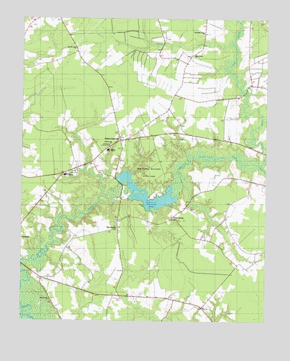
Merchants Millpond, NC USGS Topographic Map
Click on map above to begin viewing in our Map Viewer.

This topographic map contains these locations and features:
Feature Name Type Latitude Longitude GNIS ID View Map
Central Junior High SchoolSchoolN36.4354°W76.7277°1026294View Map
Chesapeake Lookout TowerTowerN36.4477°W76.7044°1026290View Map
Duke SwampStreamN36.4396°W76.6277°1025294View Map
Eason CrossroadsPopulated PlaceN36.4488°W76.7000°1020073View Map
Flat BranchPopulated PlaceN36.4132°W76.7000°1026292View Map
Gates CountyCivilN36.4449°W76.7005°1026126View Map
Gates County High SchoolSchoolN36.4457°W76.7058°1026285View Map
Gates County Rescue SquadBuildingN36.4502°W76.6984°2720368View Map
Hayes Landing (historical)LocaleN36.4274°W76.7094°1003350View Map
Hermit IslandIslandN36.3871°W76.7450°1003349View Map
Lassiter SwampSwampN36.4418°W76.6486°1025465View Map
Lebanon Grove ChurchChurchN36.4340°W76.7350°1026295View Map
Merchants Mill (historical)LocaleN36.4321°W76.6991°1003359View Map
Merchants MillpondReservoirN36.4278°W76.6857°989733View Map
Merchants Millpond State ParkParkN36.4371°W76.6844°1026289View Map
Middle SwampSwampN36.4874°W76.6777°989803View Map
Middle SwampStreamN36.4896°W76.6416°1026315View Map
Middle Swamp ChurchChurchN36.4852°W76.6622°1026287View Map
New Middle Swamp ChurchChurchN36.4943°W76.6572°1026286View Map
New Pine Grove ChurchChurchN36.4879°W76.7227°1026288View Map
Raynor SwampStreamN36.4396°W76.6277°1025637View Map
Sandy Field LandingLocaleN36.4113°W76.7336°1003360View Map
Silver SpringsPopulated PlaceN36.4177°W76.6719°1022637View Map
Sycamore Hill ChurchChurchN36.4479°W76.7038°1026291View Map
Township of GatesvilleCivilN36.4280°W76.7200°1026702View Map
VivianLocaleN36.3854°W76.6997°1003361View Map
Zion ChurchChurchN36.3807°W76.6558°1026293View Map

Note: Coordinates in the location and feature list above are referenced to NAD83 datum.


Copyright (C) 2008-2024 Ryan Niemi / Sunset Dynamics ... All Rights Reserved