TopoQuest Logo
Do you find TopoQuest useful?
Help keep TopoQuest running and adding new maps/features by donating!
Bitcoin:  19c7KJd3qBynnjoSw5npx9KScwjBe4ifkT
Litecoin:  LXs6TkuXGGXo1vDsWCkWVdjQX94eUKd6ui
Home View Maps Find Maps Find Places Resources & Links


Mallory, New York Topographic Map

USGS Map Title: Mallory, NY
USGS Map MRC: 43076C1
DRG (GeoTIFF) Download: o43076c1.tif


Neighboring USGS Topographic Map Quads:


  Mexico, NY  
43076D2
 

  Dugway, NY  
43076D1
 

  Williamstown, NY  
43075D8
 

  Central Square, NY  
43076C2
 

  Mallory, NY  
43076C1
 

  Panther Lake, NY  
43075C8
 

  Brewerton, NY  
43076B2
 

  Cicero, NY  
43076B1
 

  Cleveland, NY  
43075B8


Map MRC Location:

N44°
W77°
N44°
W76°
H8 H7 H6 H5 H4 H3 H2 H1
G8 G7 G6 G5 G4 G3 G2 G1
F8 F7 F6 F5 F4 F3 F2 F1
E8 E7 E6 E5 E4 E3 E2 E1
D8 D7 D6 D5 D4 D3 D2 D1
C8 C7 C6 C5 C4 C3 C2 C1
B8 B7 B6 B5 B4 B3 B2 B1
A8 A7 A6 A5 A4 A3 A2 A1
N43°
W77°
N43°
W76°

Mallory, NY USGS 1:24K Topographic Map Preview:
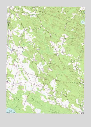
Mallory, NY USGS Topographic Map
Click on map above to begin viewing in our Map Viewer.

This topographic map contains these locations and features:
Feature Name Type Latitude Longitude GNIS ID View Map
Big Bay CreekStreamN43.2540°W76.1127°943838View Map
Big Bay SwampSwampN43.2617°W76.1077°943839View Map
Bisbo Mobile Home ParkPopulated PlaceN43.2581°W76.0034°2715149View Map
Carley Mills CemeteryCemeteryN43.3732°W76.1175°973722View Map
Constantia Census Designated PlaceCensusN43.2548°W76.0109°2389355View Map
Constantia Post OfficePost OfficeN43.2504°W76.0040°2713521View Map
Constantia Rural CemeteryCemeteryN43.2648°W76.0007°953716View Map
Deer Run Trailer ParkPopulated PlaceN43.3273°W76.1026°2715158View Map
Dutch HillSummitN43.3653°W76.0180°948856View Map
Dutch SettlementPopulated PlaceN43.3245°W76.0774°948867View Map
Dykeman CreekStreamN43.3220°W76.1116°948895View Map
Engineers AirportAirportN43.3154°W76.0142°977969View Map
Evergreen Manor Mobile Home ParkPopulated PlaceN43.3021°W76.0581°2715160View Map
GayvillePopulated PlaceN43.3059°W76.0135°950963View Map
Glenwood Golf Course and Driving RangeLocaleN43.2842°W76.0740°2715209View Map
Green Acres Christmas Tree FarmLocaleN43.3461°W76.0861°2542322View Map
Greenview Country ClubLocaleN43.2895°W76.0817°2715210View Map
Gulf BridgePopulated PlaceN43.2903°W76.0646°951911View Map
Little Bay CreekStreamN43.2556°W76.1171°955454View Map
Little FrancePopulated PlaceN43.3478°W76.0966°955533View Map
MalloryPopulated PlaceN43.3237°W76.1166°956304View Map
Mud SettlementPopulated PlaceN43.2837°W76.1138°958116View Map
New Life ChurchChurchN43.2808°W76.0696°2714752View Map
Partridge Acres Mobile Home ParkPopulated PlaceN43.3096°W76.0552°2715179View Map
Pine Grove CemeteryCemeteryN43.3205°W76.1169°2542517View Map
Potter CornersLocaleN43.3376°W76.0333°961034View Map
Potter CreekStreamN43.3206°W76.0396°961035View Map
Saint Bernadette ChurchChurchN43.2569°W76.0176°2714774View Map
Saint Francis CemeteryCemeteryN43.3400°W76.1017°955534View Map
School Number 1 (historical)SchoolN43.2775°W76.0586°2368492View Map
School Number 11 (historical)SchoolN43.3250°W76.1161°2368513View Map
School Number 12 (historical)SchoolN43.3478°W76.0967°2368514View Map
School Number 12 (historical)SchoolN43.3606°W76.0219°2368515View Map
School Number 2 (historical)SchoolN43.2847°W76.1133°2368493View Map
School Number 3 (historical)SchoolN43.2972°W76.0936°2368494View Map
School Number 4 (historical)SchoolN43.2975°W76.0597°2368495View Map
School Number 6 (historical)SchoolN43.3069°W76.0133°2368509View Map
School Number 6 (historical)SchoolN43.3733°W76.1167°2368510View Map
School Number 7 (historical)SchoolN43.3636°W76.0772°2368511View Map
School Number 8 (historical)SchoolN43.3167°W76.0811°2368512View Map
Shanty CreekStreamN43.3309°W76.1241°970599View Map
Shepard AirportAirportN43.2519°W76.0049°977968View Map
Slocum CreekStreamN43.2745°W76.0741°965434View Map
South PondLakeN43.3570°W76.0028°970635View Map
Spring BrookStreamN43.2845°W76.0005°966061View Map
The PinnacleSummitN43.2887°W76.0460°967313View Map
Threemile CreekStreamN43.2562°W76.0449°967468View Map
Toad Harbor SwampSwampN43.2567°W76.0566°967574View Map
Town of West MonroeCivilN43.2963°W76.0762°979623View Map
Union SettlementPopulated PlaceN43.3203°W76.0433°968216View Map
Union Settlement CemeteryCemeteryN43.3196°W76.0421°2542518View Map
Vorhees CornersLocaleN43.3728°W76.0833°968606View Map
West Marine Station (historical)LocaleN43.2761°W76.0683°2368491View Map
West MonroePopulated PlaceN43.2809°W76.0666°970804View Map
West Monroe CemeteryCemeteryN43.2854°W76.1038°970805View Map
West Monroe United Methodist ChurchChurchN43.2802°W76.0653°2714410View Map
West Monroe Volunteer Fire DepartmentBuildingN43.2845°W76.0645°2701334View Map
Whig HillPopulated PlaceN43.2937°W76.0758°971034View Map
Woodland Manor Mobile Home ParkPopulated PlaceN43.3012°W76.0541°2715191View Map

Note: Coordinates in the location and feature list above are referenced to NAD83 datum.


Copyright (C) 2008-2024 Ryan Niemi / Sunset Dynamics ... All Rights Reserved